

Meetings and Announcements
Upcoming Meetings
No meetings scheduled currently
Northern Recreation Public Meeting
The purpose of this meeting is to collect input from public stakeholders regarding recreational use of District conservation lands in the northern recreation area. The northern recreation area includes 18 District properties located in Alachua, Baker, Clay, Duval, Flagler, Marion, Nassau, Putnam, and St. Johns counties. All members of the public are encouraged to participate in this meeting.
Event details:
- Date: Tuesday, Nov. 3
- Time: 6:00 p.m. to 8:00 p.m.
- Where: District Headquarters Executive Building – Governing Board Room – 4049 Reid St., Palatka, FL 32177
District staff will receive comments from the public during the meeting. If you are unable to attend in person and would like to provide a comment or question, please email NorthernRecreationComments@sjrwmd.com. The answers will be returned via email after the meeting.
Topics, as they relate to public recreational utilization of District lands, will include:
- Overview of recreation on District lands
- Land management updates North and West regions
- Opportunity for public comment
If you have any questions or comments, please email Patrick McCord at pjmccord@sjrwmd.com or call (386) 643-1154.
Southern Recreation Public Meeting
The purpose of this meeting is to collect input from stakeholders regarding recreational use of District conservation land in the Upper St. Johns River Basin, South Region
Event details:
- Date: Tuesday, Oct. 27
- Time: 6:00 p.m. to 8:00 p.m.
- Where: Palm Bay Service Center – Blue Cypress Room – 525 Community College Parkway SE, Palm Bay, FL 32909
District staff will receive comments from the public during the meeting. If you are unable to attend in person and would like to provide a comment or question, please email SouthernRecreationComments@sjrwmd.com. The answers will be returned via email after the meeting.
Topics, as they relate to public recreational utilization of District lands, will include:
- Overview of recreation on District land in the South Region
- South Region land management and operation updates
- Opportunity for public comment
If you have any questions or comments, please email Patrick McCord at pjmccord@sjrwmd.com or call (386) 643-1154.
Central Recreation Public Meeting
The purpose of this meeting is to collect input from public stakeholders regarding the recreational use of District conservation lands in the central recreation area. The central recreation area includes 18 District properties located in Brevard, Flagler, Lake, Marion, Orange, Putnam, Seminole and Volusia counties. All interested members of the public are encouraged to participate in this meeting.
Event details:
- Date: Tuesday, Oct. 20
- Time: 6:00 p.m. to 8:00 p.m.
- Where: Apopka Service Center – Econ Conference Room – 2501 S Binion Rd, Apopka, FL 32703
District staff will receive comments from the public during the meeting. If you are unable to attend in person and would like to provide a comment or question, please email CentralRecreationComments@sjrwmd.com. The answers will be returned via email after the meeting.
Topics, as they relate to public recreational utilization of District lands, will include:
- Overview of recreation on District lands
- Land management updates North Central, Southwest and South Central regions
- Opportunity for public comment
Recreation Announcements
McDonald Canal Road/North Shore Trailhead
The North Shore Trailhead and McDonald Canal Road will be closed September 28 through October 9th for construction. This includes the north-south section of the Lake Apopka Loop Trail Spur. A Detour is available on Marsh Rabbit Road and Lake Level Canal Road. Please use caution, there will be dump truck in the area.
The road immediately east of the Flow-Way Bump Basin will be closed for construction. The road west of the pump basin will remain open. The portion of the Lake Apopka Loop Trail, immediately north of the Pump Basin will remain open, but users should exercise caution. This closure will be from September 28th through October 9th.
Buffer Preserve Drive Weekday Closure for Repairs
Buffer Preserve Drive will be closed to public access on weekdays from October 5 through November 5 to allow for roadway repairs.
During this period, visitors will not be able to access St. Sebastian River Preserve State Park from the Babcock entrance on weekdays. The area will remain accessible on weekends unless otherwise noted.
We appreciate your patience and understanding as these improvements are completed to help maintain safe access to the preserve.
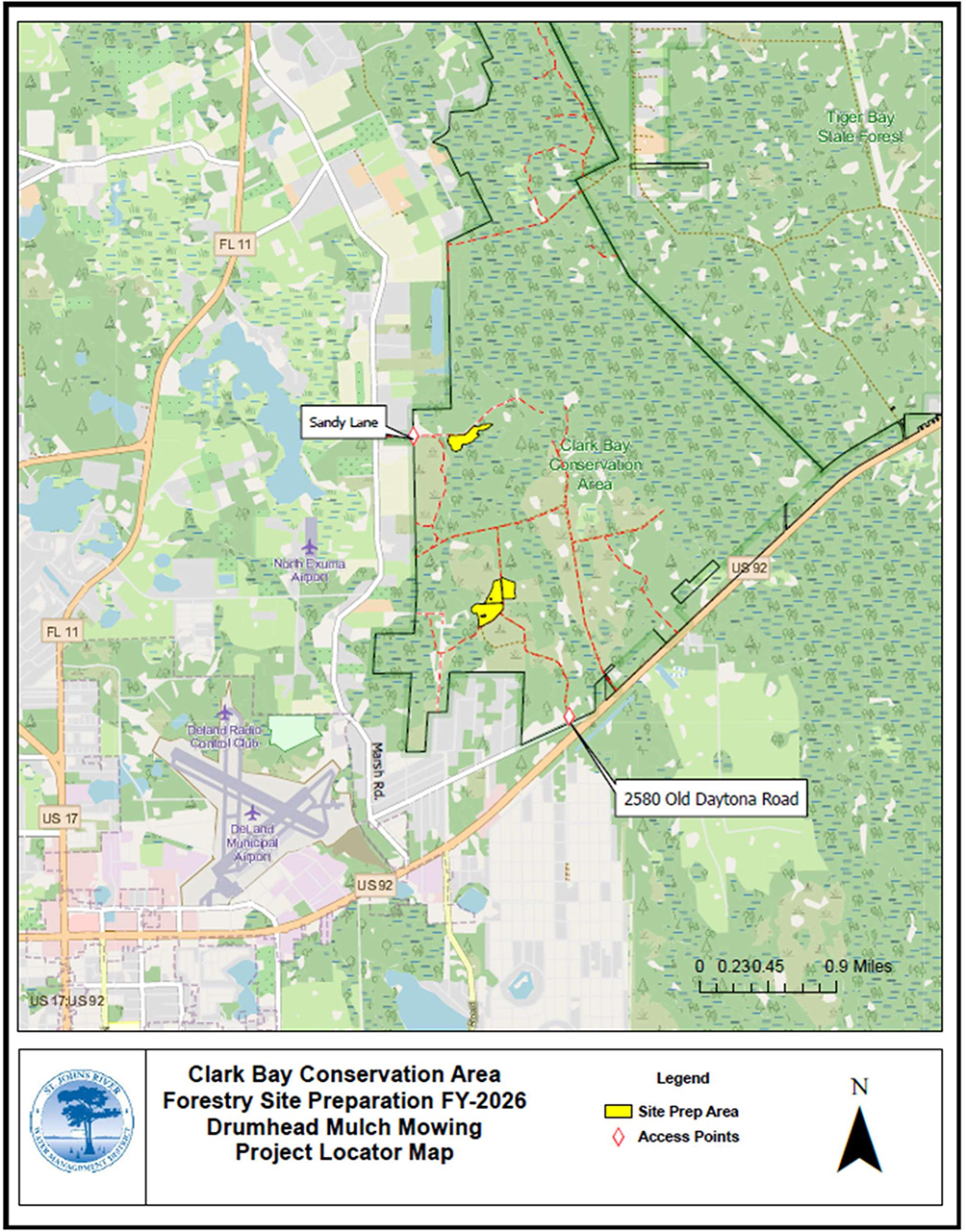
Forestry site preparation will take place Sept. 21–30, 2026, on 38.7 acres at the Clark Bay Conservation Area (see map). The project consists of mulch mowing to prepare the site for tree planting. Please use caution when accessing the property for recreation.
View PDF
Lake Apopka Loop Trail Closure
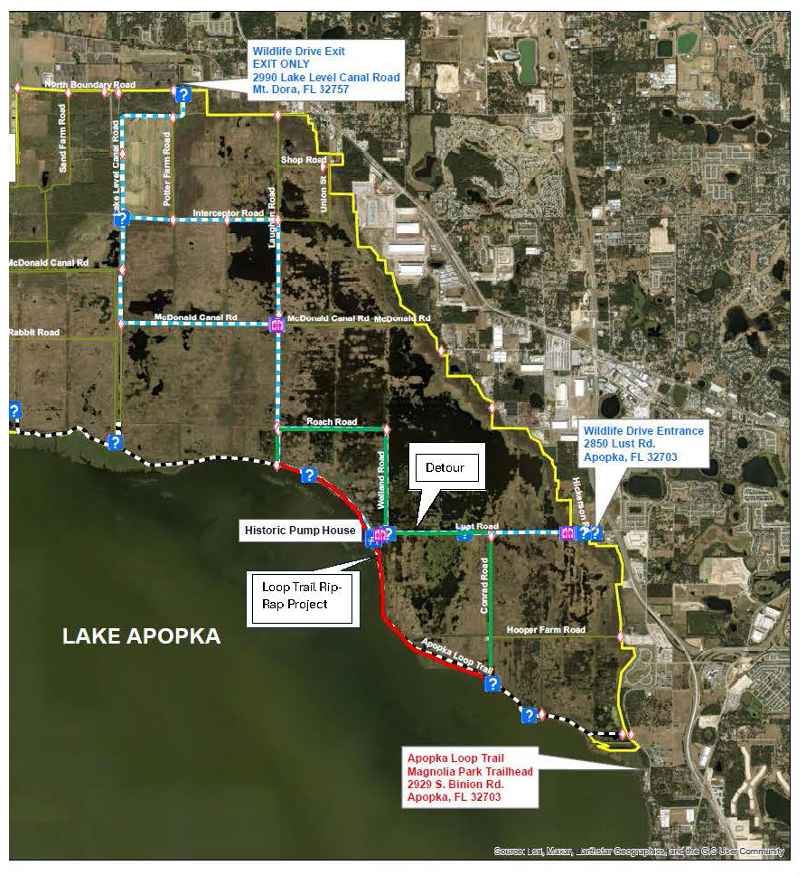
Operations and Maintenance and their contractor will be restoring riprap along the lakeshore levee. A portion of the Lake Apopka Loop Trail will be closed between Conrad Road and Laughlin Road. Please use the detour but be careful because dump truck will be delivering material to the work locations. The project will take up to two months to complete. Work will be from Monday through Thursday and will not affect the Lake Apopka Wildlife Drive.
Pellicer Creek Conservation Area
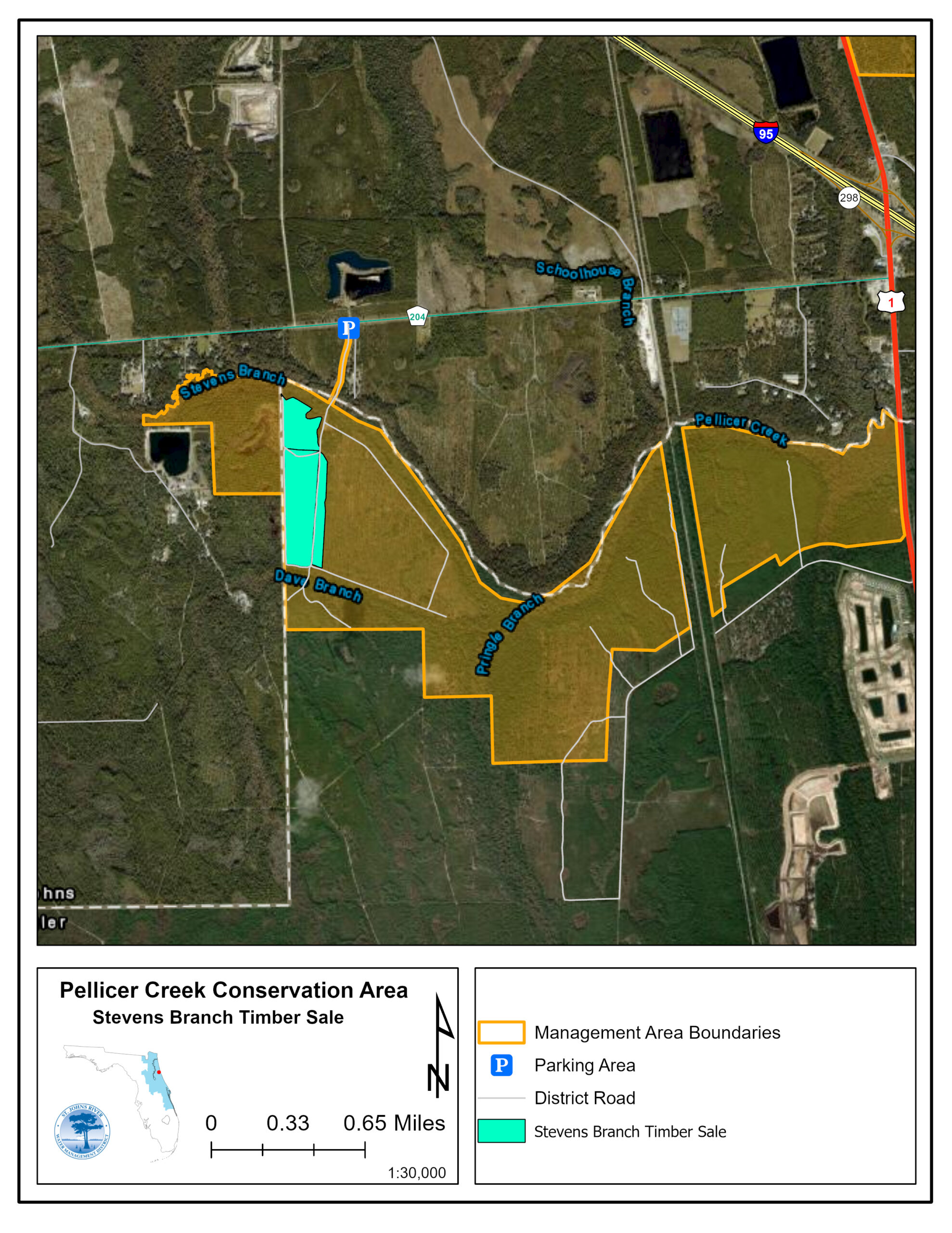
An area within the Pellicer Creek Conservation Area (see map) is undergoing a pine thinning. Tree stand densities are high, and the purpose of the thinning is to remove diseased, defective and suppressed trees to create openings in the canopy, freeing up growing space for the healthiest trees. Please use caution when accessing the property for recreation. The contract allows the work to be conducted through April 13, 2027.
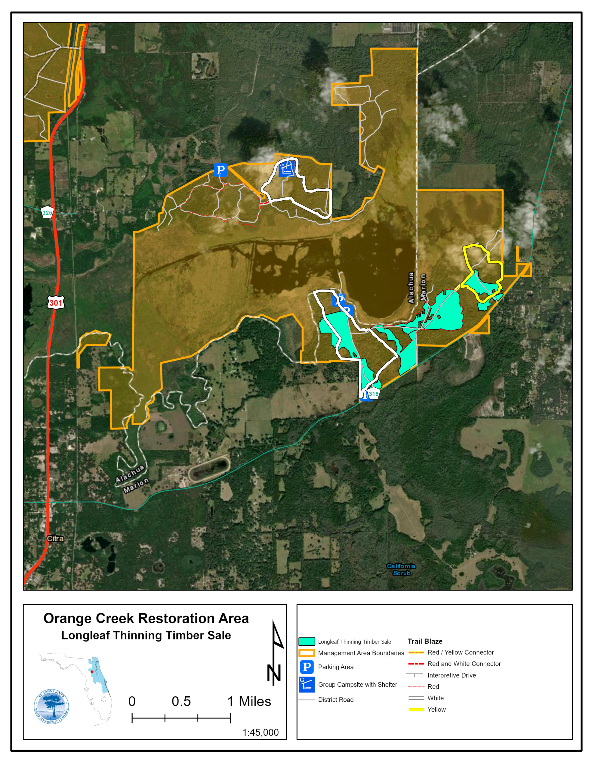
An area within the Orange Creek Restoration Area (see map) is undergoing a pine thinning. Tree stand densities are high, and the purpose of the thinning is to remove diseased, defective and suppressed trees to create openings in the canopy, freeing up growing space for the healthiest trees. Please use caution when accessing the property for recreation, including hunting. The contract allows the work to be conducted through April 1, 2027.
Lochloosa Wildlife Conservation Area
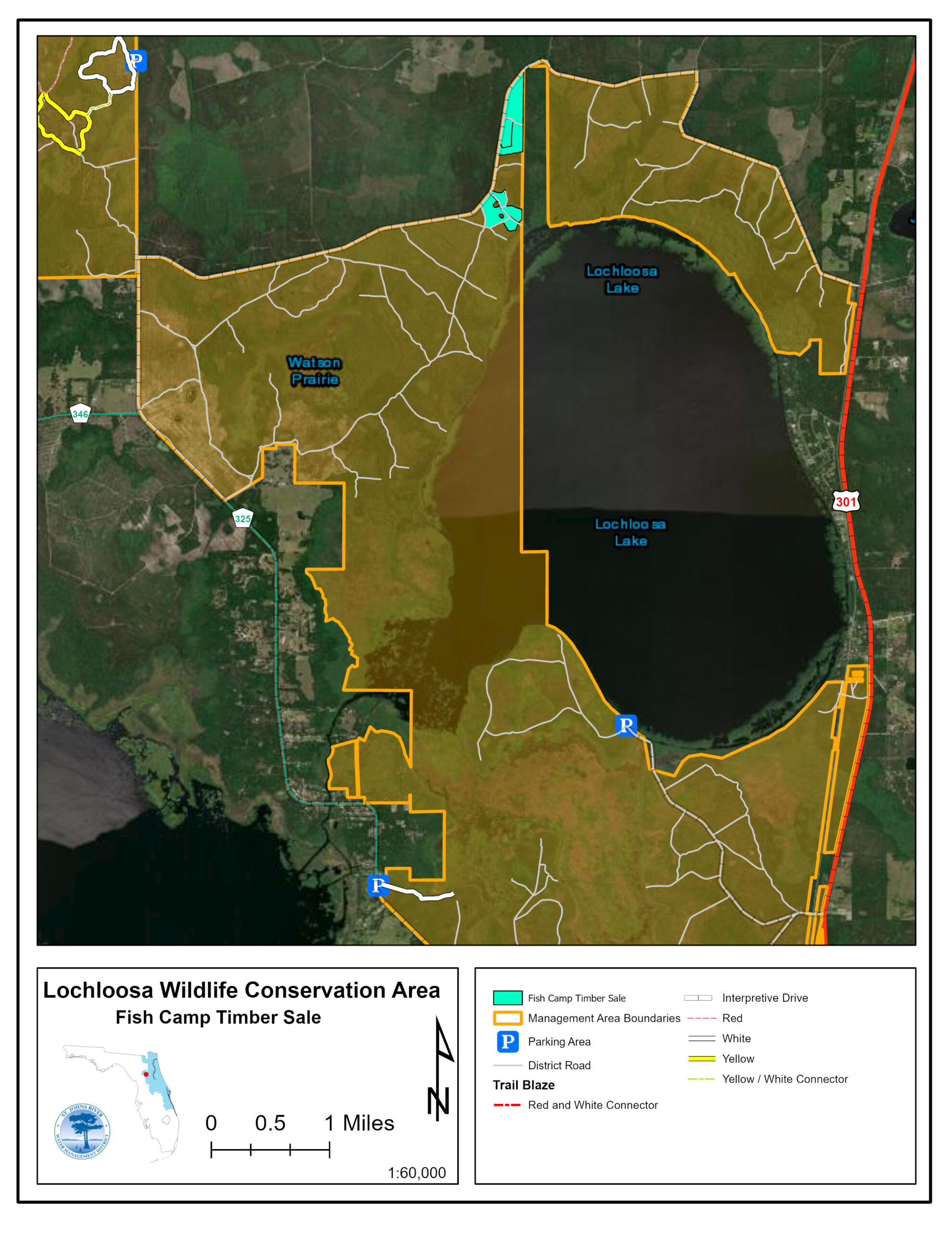
An area within the Lochloosa Wildlife Conservation Area (see map) is undergoing a pine thinning. Tree stand densities are high, and the purpose of the thinning is to remove diseased, defective and suppressed trees to create openings in the canopy, freeing up growing space for the healthiest trees. Please use caution when accessing the property for recreation, including hunting (quota permit required). Work is anticipated to continue through May 15, 2027.
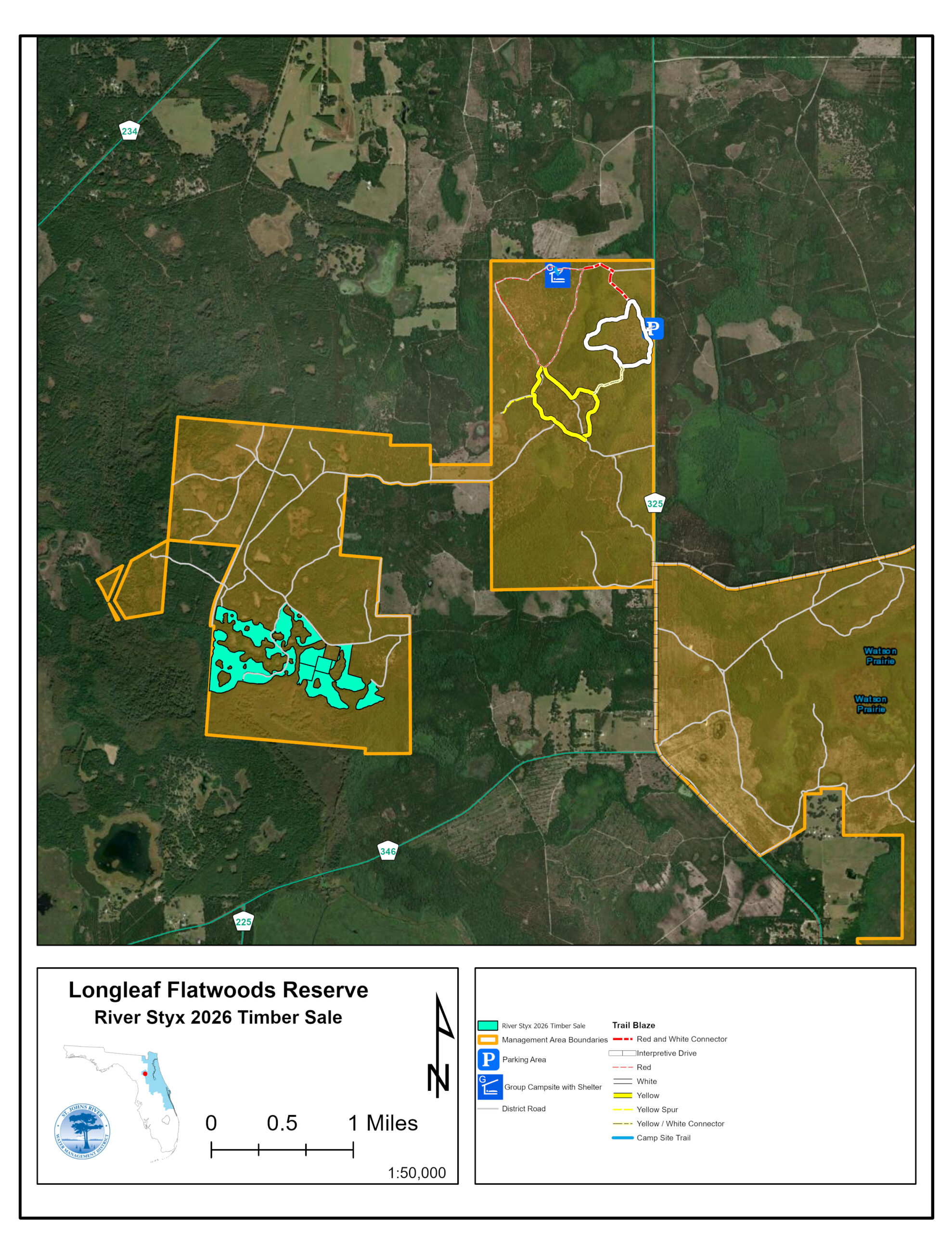
An area within the River Styx Tract of the Longleaf Flatwoods Reserve (see map) is undergoing a pine thinning. Tree stand densities are high, and the purpose of the thinning is to remove diseased, defective and suppressed trees to create openings in the canopy, freeing up growing space for the healthiest trees. Please use caution when accessing the property for recreation. The contract allows the work to be conducted through April 2, 2027.
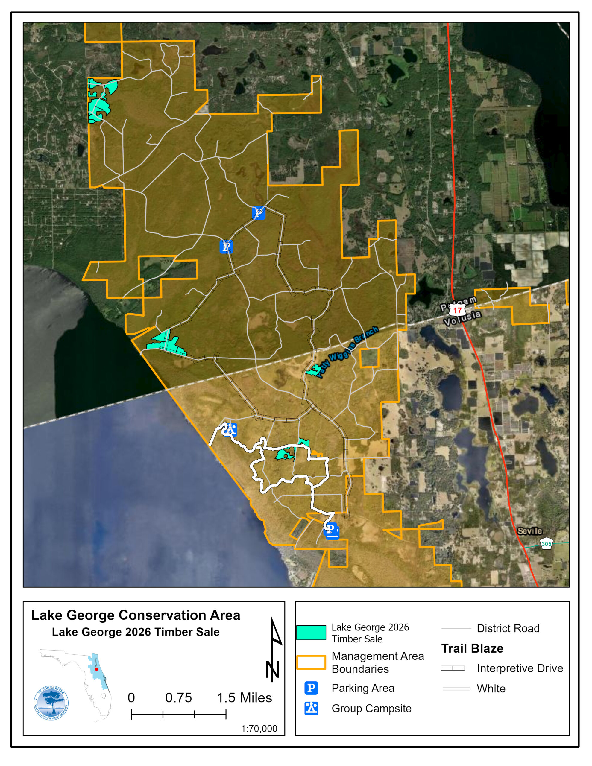
An area within the Lake George Conservation Area (see map) is undergoing a pine thinning. Tree stand densities are high, and the purpose of the thinning is to remove diseased, defective and suppressed trees to create openings in the canopy, freeing up growing space for the healthiest trees. Please use caution when accessing the property for recreation, including primitive tent camping (reservation required) and hunting. Work is anticipated to continue through June 15, 2027.
For more information about property closures, please visit recreation and lands.
Temporary Website Outages
We want your visit to sjrwmd.com to be a positive and productive experience. At times, we will need to perform routine hardware and software maintenance that may cause some areas of the site to be intermittently off-line. We do apologize for this temporary, but necessary, inconvenience. We are working diligently to quickly restore complete functionality to the site.
Next scheduled outage:
- None scheduled at this time
Governing Board
For schedules, agendas, and livestream links visit Governing Board.
Office Closures
District offices will be closed on Sept. 7, 2026 in observance of Labor Day.