

A dry January leaves abnormally dry conditions Districtwide
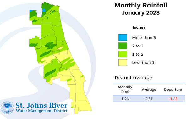
A map illustrates rainfall conditions in January across the St. Johns River Water Management District.
***Updated on March 10, 2023.
PALATKA, Fla., Feb. 14, 2023 — After two months of low rainfall, the St. Johns River Water Management District’s 18-county region is experiencing abnormally dry conditions, especially in Nassau, Baker and portions of Duval and Clay counties where moderate drought conditions are developing according to the U.S. Drought Monitor.

A map illustrates rainfall conditions in January across the St. Johns River Water Management District.
A full report outlining January’s hydrologic conditions was presented at the District’s Governing Board meeting Tuesday. Highlights include:
Rainfall
- Districtwide, December rainfall averaged 1.26 inches, which is 1.35 inches below the average for the month.
- Districtwide, the cumulative rainfall total for the past 12 months is 54.41 inches, which is 3.40 inches above the long-term average.
- County-based rainfall totals ranged from a high of 2.2 inches in Nassau County to 0.5 inches in Brevard County.
- While every county in the District received below average rainfall, the southern counties were particularly dry with Brevard and Indian River counties receiving only 0.5 inches of rain.
Groundwater
- At the end of January, Upper Floridan aquifer conditions (groundwater levels) were in the high or normal range Districtwide.
- Groundwater levels expressed as a single Districtwide index are at the 72nd percentile Districtwide. This means that since 1980, aquifer levels have been higher than they currently are about 28 percent of the time.
Spring flows
- The mean monthly flow at Silver Springs decreased to 634 cubic feet per second (cfs), or 410 million gallons per day (mgd), which is a 16 cfs decrease from December’s mean and remains in the normal range for this time of year.
- At the Blue Spring station in Volusia County, the mean monthly flow was 169 cfs, or 109 mgd.
- At Rock Springs, the monthly mean flow decreased 2 cfs to 65 cfs (42 mgd), which is in the high range for January.
- Mean monthly flow at Wekiwa Springs decreased to 73 cfs (47 mgd), which is in the high range for the time of year.
To learn more about rainfall totals and other hydrologic data collected, visit www.sjrwmd.com.
Visit WaterLessFlorida.com for tips to help landscapes thrive while saving water and money. Follow the water conservation conversation at #sjrwmd #waterconservation #savewater.