

From drizzles to downpours: Unpacking September’s rainfall patterns
A map illustrates rainfall conditions in September across the St. Johns River Water Management District.
PALATKA, Fla., Oct. 12, 2023 — In September, the St. Johns River Water Management District noted disparity in rainfall patterns. Some areas received a mere 3 inches, while others saw over 9 inches. The bulk of September’s rainfall occurred in the final week, marked by a significant rain event impacting Flagler, Volusia and south Putnam counties. This event led to localized flooding, particularly in Haw Creek, a tributary of Crescent Lake that feeds into the St. Johns River, eventually reaching a moderate flood status as reported by NOAA’s River Observation data.

A map illustrates rainfall conditions in September across the St. Johns River Water Management District.
Simultaneously, vulnerable areas along the lower St. Johns River, like Astor, experienced minor flooding thanks to a combination of king tides and a persistent north-northeast wind. Residents in these regions should continue to monitor river levels, as additional instances of king tide-induced flooding are anticipated at the end of October and again at the end of November.
A full report outlining September’s hydrologic conditions was presented at the District’s Governing Board meeting Oct. 10. Highlights include:
Rainfall
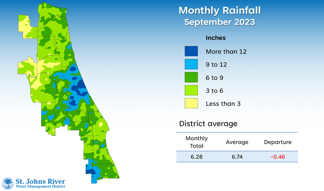
- Districtwide, September rainfall averaged 6.28 inches, which is slightly below the monthly average by 0.46.
- Over the past 12 months, rainfall was below average in most of the District, except for the southern end and coastal areas of St. Johns, Flagler, Volusia and Brevard counties.
- Districtwide, the cumulative rainfall total for the past 12 months is 47.21 inches, which is 3.80 inches below the long-term average.
- County-wide totals ranged from 53.9 inches in Indian River County to 43.2 inches in Nassau, the District’s northernmost county.
Groundwater
- Upper Floridan aquifer conditions were generally normal at the end of September, except for some areas in Duval County, where conditions were in the low range.
- Small zones of high conditions were recorded in south Volusia, east Seminole, northern Brevard and Alachua counties.
- Districtwide groundwater levels, expressed as a single index, fall within the 49th percentile, considered normal for this time of year.
Spring flows
- Silver Springs recorded a mean monthly flow of 627 cubic feet per second (cfs), or 405 million gallons per day (mgd), within the normal range for this period.
- Blue Spring station in Volusia County reported a mean monthly flow of 157 cfs, or 101 mgd, which is in the high range.
- Rock Springs experienced a slight increase in mean monthly flow, falling within the normal range at 61 cfs (39 mgd).
- Wekiwa Springs maintained a mean monthly flow of 64 cfs (41 mgd), consistent with the normal range for this time of year.
To learn more about rainfall totals and other hydrologic data collected, visit www.sjrwmd.com.
Visit WaterLessFlorida.com for tips to help landscapes thrive while saving water and money. Follow the water conservation conversation at #sjrwmd #waterconservation #savewater.