

Frequently asked questions
| Number | Topic/Keywords | Question | Answer | ||||||||||||||||||
|---|---|---|---|---|---|---|---|---|---|---|---|---|---|---|---|---|---|---|---|---|---|
| 147 | Construction | If an operator is seen working outside of a turbidity barrier, is this a violation of the construction permit? | Yes, it is considered non-compliance with the protocols associated with the project. On May 9, the contractor did briefly move the bucket into an area that was not surrounded by barriers, which breached protocol. The issue was reported to the St. Johns River Water Management District on May 14, 2019, which was five days later, and the district immediately reported the incident to the FDEP and the USACE while isolating the area behind a turbidity barrier. There were no turbidity plumes noted at any time, and multiple turbidity measurements failed to document a water quality violation. In addition, the district met with the contractor and drafted an addendum to the protocol designed to prevent future incidents. The FDEP characterized this incident as not actionable and stated, “We believe they acted responsibly once they found there was an issue and with the absence of a water quality violation have no basis to prevent their continuing work.” | ||||||||||||||||||
| 146 | Construction, navigation | If the excavator arm goes under the waterline to remove sediment from open water in the project area, is this a violation of the permits? | Under limited circumstances, the operator can go below the waterline and remove sediment from open water. This action is not a violation of the permit. At times, the excavator’s movement can produce “ruts” in the bottom of the ditch or material collects near the excavator during leveling. Standard construction practice is to “clean-up” the worksite, which includes smoothing or removing raised or rutted areas in ditches. The contractor has placed some of this material on restored surfaces to yield a beneficial use by creating valuable salt marsh. This “clean-up” also ensures navigation in the area is not impeded. In response to this question, the Florida Department of Environmental Protection (FDEP) has stated, “We have concluded the activities as outlined are appropriate for the restoration project authorized and do not find it to be in violation of the Noticed General Permit.” UPDATE: The District has approved the contractor’s request to use a second excavator. The new excavator will be brought into the project area on or after June 13, 2019. The second excavator will help to expedite completion of the project and finishing more segments during the growing season should also help the restored wetlands revegetate sooner. The second excavator is an amphibious Caterpillar 312D, which is slightly smaller than the Caterpillar 320D already in use. 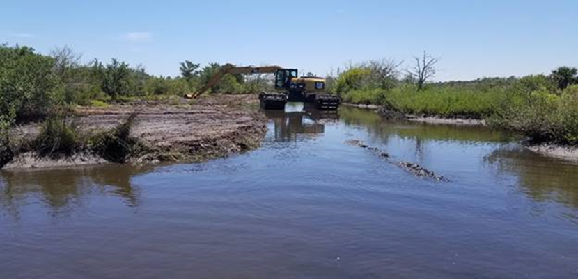 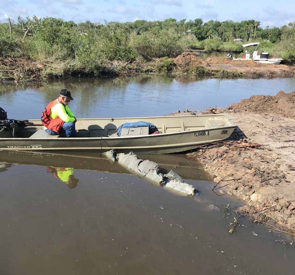 |
||||||||||||||||||
| 145 | Construction | Were turbidity barriers placed within 40 to 50 feet of a homeowner’s property? | The locations for several barriers were changed when buffers were added to address the concerns of local stakeholders. The buffers do not change the area covered by the permits, but they will reduce the area to be restored. Maps showing planned locations for barriers can be found at: stg-sjrwmd-test.kinsta.cloud/facts/flagler-wetland-restoration-project/monitoringdata/#turbidity. The presence of a turbidity barrier does not indicate that restoration will take place immediately adjacent to it. Turbidity barriers are placed around work areas as part of best management practices to comply with permit conditions. If a citizen has a concern about the location of a turbidity barrier, they are asked to contact the district via email at FRestoration@sjrwmd.com, by phone at 386-329-4334, or at 386-983-9869 for after-hours needs. | ||||||||||||||||||
| 144 | Construction, navigation | Have turbidity barriers closed homeowners’ navigation lanes, which some residents claim is a violation of the permit, impeding navigation and allowing this debris and muck to flow in the buffer zone? | All natural waterways remain open to navigation. In fact, after listening to stakeholder concerns, additional navigational routes were identified for preservation. One of those identified routes in Section F has been closed during restoration. It will reopen after the barriers are removed, which can be up to two months after restoration is complete. FDEP Northeast District compliance staff visited the site on April 10 and found the project in compliance with permit requirements. | ||||||||||||||||||
| 143 | Mosquito control | Some residents claim the district’s contractor never properly tested for DDT, digging only about a foot for its samples, rather than four feet. Was that enough? | A diligent review of relevant records found no evidence that DDT was applied in this area. As a result, sampling for organochlorine pesticides was not planned. However, after listening to concerns from the public, the partners agreed to conduct sampling and analysis to allay fears of widespread contamination at levels of concern. Five samples were collected for analysis to detect organochlorine pesticides (including DDT) in the spoil that will be affected during restoration. Samples were collected in accordance with the guidelines established in FDEP Standard Operating Procedures by a certified contractor hired by the district. Soil samples were from spoil piles shown in a map found at: aws.sjrwmd.com/SJRWMD/facts/Flagler-wetlands/faq/Flagler_dragline_sediment_full.jpg. A certified laboratory analyzed the samples, and no samples showed levels of pesticides or their breakdown products near the state’s most stringent standards. Fortunately, the samples provided evidence that concerns about widespread contamination with DDT were not valid. | ||||||||||||||||||
| 142 | Construction | Are barriers being moved to stop stakeholders from observing the project? | Barriers are put in place at active construction sites for safety. Citizens can view what is happening in the project area, as evidenced by the videos and pictures already taken and posted by stakeholders. In addition, pictures and aerial imagery of completed areas are posted to the project website when they are available. Video clips of Section A were recently posted. | ||||||||||||||||||
| 141 | Other | Are there stakeholders or stakeholder groups who support the project? | Yes, including the Friends of Gamble Rogers Memorial State Recreation Area, East Flagler Mosquito Control District, the Environmental Council of Volusia and Flagler Counties, Florida Audubon, the Nature Conservancy and the Atlantic Coastal Fish Habitat Partnership. | ||||||||||||||||||
| 140 | Habitat | Is the project creating more open water, rather than wetlands? | Open water and intertidal wetlands are different, as intertidal wetlands are covered and exposed by tides, whereas open water is not. The project restores intertidal wetlands, which combats the creation of open water due to erosion and adds resilience to the system. | ||||||||||||||||||
| 139 | Aesthetics, Construction | A resident has commented that they smelled a foul odor coming from the project area. | The project ecologist and other staff working at the site March 18-20 have not noticed unusual odors. | ||||||||||||||||||
| 138 | Construction, Water Quality | We are concerned with grass and sediment that is accumulating on the oysters. | Prior to the project starting, algae and sediment were observed and documented on oysters. In fact, sediment covered up to 35 percent of the area surveyed on one reef and an average of 10 percent of the area surveyed on 21 reefs. Recent photos (see Image 5) provided by residents were reviewed by staff and compared to observations made before work began. The comparison did not indicate that restoration caused an accumulation of sediment or algae. Project staff have provided Image 6 below to show stakeholders the oysters in the area were experiencing algae cover prior to the project commencing.  Image 5 (March 14, 2019, provided by residents) 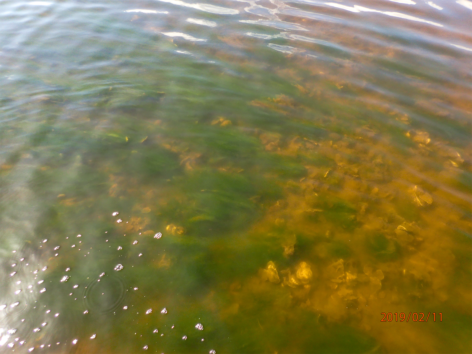 Image 6 (Feb. 11, 2019) Oysters in the project area experienced algae cover prior to construction. |
||||||||||||||||||
| 137 | Construction, Water Quality | Concerned neighbors are seeing green algae in the project area. Why? | Staff observed and documented what appeared to be filamentous algae in and around the project area before the construction started. See Images 3 and 4 below. Our FWC partner believes it may be a type of Ulva (it will need to be examined closely to determine which species). This naturally occurring algae occupies hard substrates, such as oysters, seawalls, rip rap and pilings throughout Florida. The fact that algae were present across a wide area before work began clearly indicates its growth is not related to the project or construction. Note, FDEP has determined that this waterbody is impaired, with persistently high concentrations of chlorophyll-a indicating the presence of excess nutrients (See FAQ No. 75). Excess nutrients can fuel blooms of filamentous algae. Staff will continue to monitor water quality in the project area and post the data on the web page. Also, as far as Images 3 and 4 below, the appearance of the algae will vary with tidal stage, and it may lay on the oysters during a low tide. When staff visited the area on March 19 and again on March 20, filamentous algae was seen, but no formations of algae as pictured in Image 3 below were observed.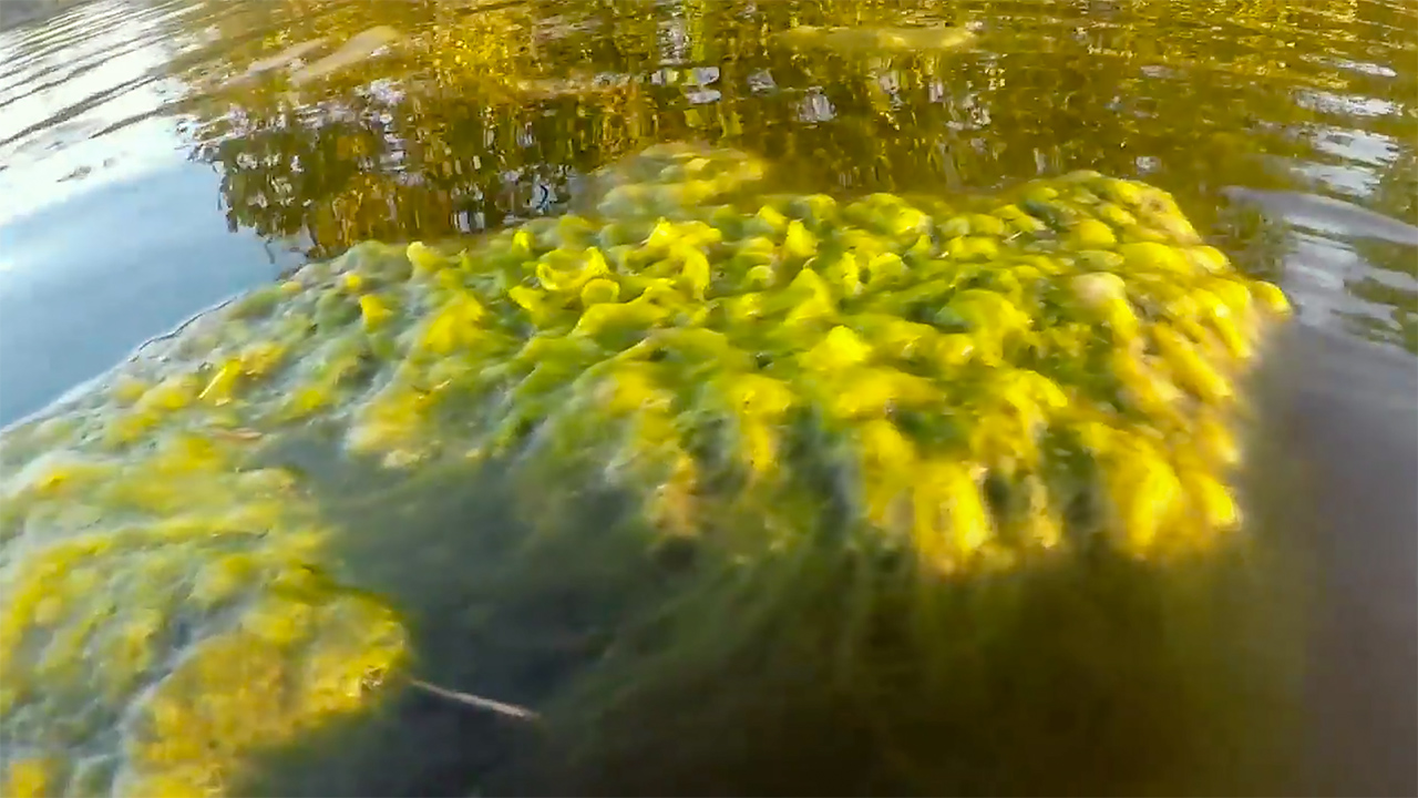 Image 3  Image 4 |
||||||||||||||||||
| 136 | Aesthetics, Construction | We have observed debris created by the restoration effort. The district needs to show the stakeholders/community pictures of the devastation behind the turbidity barriers. | The debris, as pictured below in Image 1, clearly demonstrates the effectiveness of the project area’s turbidity barriers. This “debris” contains small pieces of plants and bushes removed during the restoration process. This debris is a natural occurring byproduct of the restoration process. Most of the material will be pushed up on shore by tides, and some will fall to the floor of the marsh. The district’s team reviewed pictures and video sent to us from a neighbor on March 15, 2019, and no one found the images indicated a problem. District staff have said on many occasions that it will not look “nice” during the beginning phase of restoration. The photo below represents just such a moment in time, and as the tides change, so does the appearance. Several days later, about half of the debris had dissipated. By March 20, most of the debris was gone (see Image 2 below). It also is important to note that turbidity measurements, which are available on the project web page, show no issues of concern.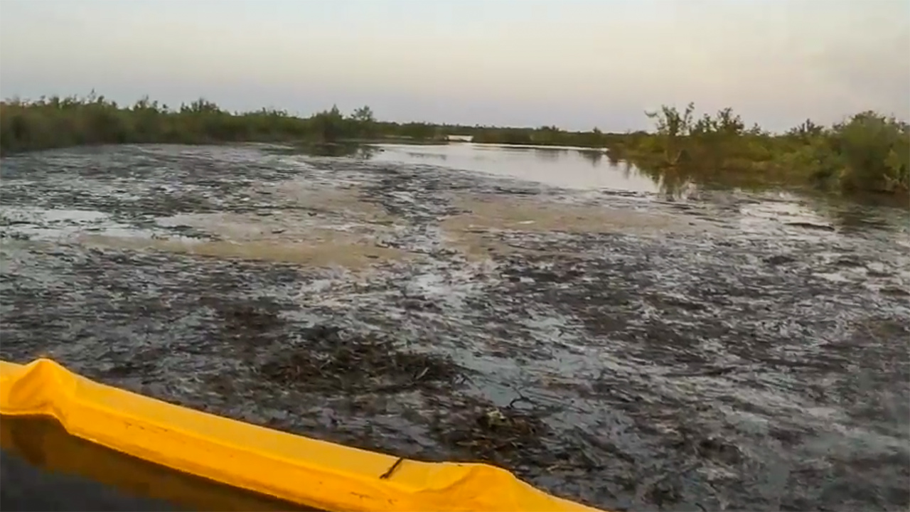 Image 1 (March 14, 2019): Debris being contained by a turbidity barrier within a section undergoing restoration 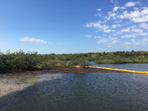 Image 2 (March 20, 2019) |
||||||||||||||||||
| 135 | Monitoring, Partners, Construction | How can citizens help as the project is under way? |
|
||||||||||||||||||
| 134 | Navigation | When it comes to Navigation, Section A is used to get into that area off the ICW. I have spoken to many anglers that fish that area and it is one of the deepest ditches that allow access at low tide. | We will preserve access to the ICW, but not access to all paths to the ICW or all fishing holes. |
||||||||||||||||||
| 133 | Construction | This project site calls for burying the vegetation with the excavator, previous sites like Cedar Creek that have been deemed successful show the “buried” vegetation is currently not buried. Is this the type of “monitoring we are going to see at the Flagler ditch restoration site? These are recent pics from Cedar Creek showing “buried” vegetation.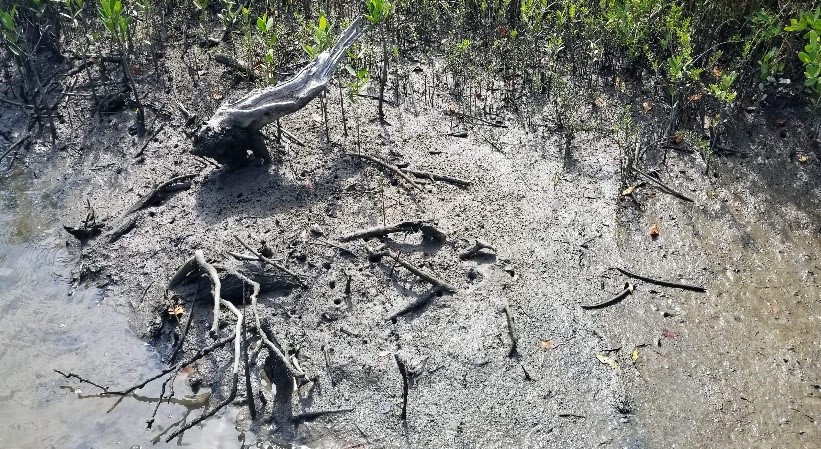 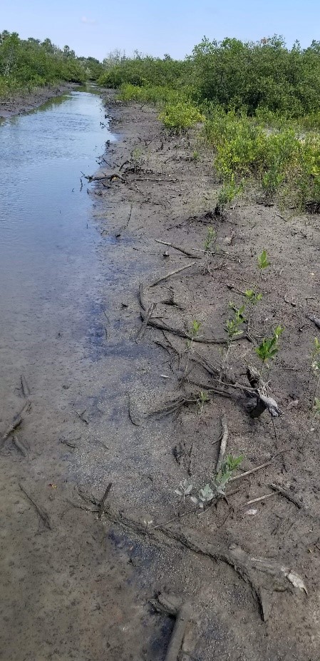 | We will continue to monitor this site much like every other restored site. This is a natural wetland, and one would expect to find parts of trees and sticks. Note carefully, the banks of the remaining ditch exhibit no evidence of erosion, and multiple types of established or establishing vegetation dominate the vista. |
||||||||||||||||||
| 132 | Monitoring | Are “nearby” sites still being monitored? Does the monitoring include aerial photography analysis of potential wet land loss? | We will continue with our ambient water quality monitoring, something not directly affiliated with this project. We will also continue to track via aerial photography, as well as through a partnership with a local university to take drone footage of the proposed project area. For the areas other than the proposed project area, we continue to use aerial photography. This is part of the process we utilized to document the loss in wetlands. We examine aerial photography on a regular basis, and along with recent reconnaissance, we have not documented loss of restored wetlands. | ||||||||||||||||||
| 131 | Science | Partners say the project site is losing up to 1 acre of land per year. The partners are analyzing the loss with aerial photography. Where can I see the aerial photography analysis? | Look at our webpage and to question #73 and Appendix: Continued Degradation. https://stg-sjrwmd-test.kinsta.cloud/facts/flagler-wetland-restoration-project. As written by the partners: "The current site was selected because it was damaged and degrading on state land and near previous successful restoration.” | ||||||||||||||||||
| 130 | Mosquito control | The community is very concerned regarding the possibility of DDT in the Spoil Mounds and it being released into the waterway. Due to the extensive efforts the USACE went through to control mosquitoes, it would not be surprising to find DDT in our area. The district has committed to testing for DDT by collecting and analyzing soil samples from mounds that will be disturbed. Will testing be done prior to disturbing the area to protect citizens and what percentage of the spoil piles will be tested for DDT? When will those results be public? | Soil samples were collected from five spoil piles on Nov. 7, 2018, (see map below) and subsequently analyzed for organochlorine pesticides (including DDT). DDT was not detected in the samples, and no samples contained levels of pesticides or their breakdown products anywhere near the state’s most stringent standards.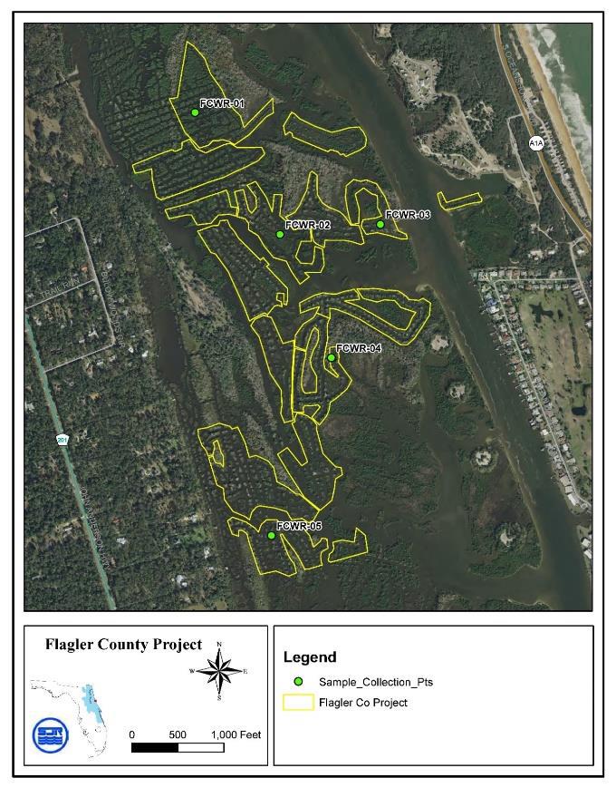 Map showing sites sampled for organochlorine pesticides |
||||||||||||||||||
| 129 | Fish, Habitat, Water quality | We have heard from a multitude of people that the fishing and environment has been extremely compromised in some of the previous project areas and the water quality has not improved. The stories of the residents that have had negative experiences with dragline ditch restoration projects, is one of the main reasons the Flagler Community is so concerned. Instead of spending taxpayer money on further projects, why can’t those funds be reallocated to assist the areas that are still struggling in Volusia County? | We have received no tangible evidence of damage to the environment or fishing due to past restoration. In addition, we have provided considerable evidence that restoration does not pose a risk as shown by a suite of analyses. They demonstrate that the process does not adversely affect flooding, water quality, oysters, fiddler crabs, fish or birds (see Appendices Effects on Water Levels and Waves, Effects on Water Quality, Effects on Oysters, Effects on Fish, and Effects on Vegetation, Fiddler Crabs and Birds). |
||||||||||||||||||
| 128 | Other, Navigation | If clear waterway access to homeowners can be mapped, determined and agreed upon, will you restructure the intended demolition areas? Will you shrink the size of the project to areas that have fewer trees, oysters and further from residential areas? | We have sought and will consider all input on access and boundaries. Paths allowing access to the Intracoastal Waterway have been preserved. Not every path will be preserved but access will. In addition, some adjustment to the project boundary is being considered. We are operating in good faith to both establish good relations with the homeowners and maintain the integrity of the project. |
||||||||||||||||||
| 127 | Habitat, Permitting | Per Permit requirements: File No: 18-036427-001-EG Page 10 (c) All in-water activities, including vessel operation, must be shut down if a listed species comes within 50 feet of the work area. Activities shall not resume until the animal(s) has moved beyond a 50-foot radius of the in-water work, or until 30 minutes elapses since the last sighting within 50 feet. Animals must not be herded away or harassed into leaving. All onsite project personnel are responsible for observing water-related activities for the presence of listed species. File No: 18-036427-001-EG Page 12 (e) Construction, use, or operation of the structure or activity shall not adversely affect any species which is endangered, threatened or of special concern, as listed in Rules 68A-27.003, 68A27.004 and 68A-27.005, F.A.C. Many residents in this area have seen a Florida Panther that lives along and in this marsh area. One resident has videotaped it along the water’s edge. How do you intend to follow through with this construction based on this knowledge and the requirement above? | The restored wetland will keep the area from converting to open water, which should benefit panthers. In addition, our contractor states: "Perry Construction Co., Inc has retained Woods & Lake Management, as an environmental company with over 35 years' experience, to provide site specific training classes to our employees on the identification of existing non-endangered, threatened and endangered species specific to the work site." |
||||||||||||||||||
| 126 | Water quality, Monitoring | Do you intend to test water quality coming from upstream pollutants? i.e. City of Flagler beach? | The district's sampling of water quality will continue for the foreseeable future. Sites are located to the north and south of the proposed project area (see map below).  Sampling sites for water quality surveys. The Florida Department of Environmental Protection (FDEP) takes the lead on addressing water quality through an evaluation that is applied throughout the state. Impairments are based on data collected in the relevant waterbody, and confirmed impairments are addressed by local stakeholders during development and adoption of a total maximum daily load (TMDL), which represents the load of contaminants that the system can assimilate without showing signs of impairment. A plan to achieve the relevant reductions, termed a Basin Management Action Plan (BMAP), also is developed and adopted. An alternative is for stakeholders to develop a Reasonable Assurance Plan (RAP) before impairment is confirmed. At this time, FDEP is implementing the TMDL process in the waterbody just to the north (WBID 2363D, https://floridadep.gov/dear/water-quality-evaluation-tmdl/content/final-tmdl-reports). |
||||||||||||||||||
| 125 | Mosquito control | According to the Daytona Beach News Journal Article dated August 22, 2018- 'The nearly daily rainfall is creating ideal habitat, especially for salt marsh mosquito populations exploding in Oak Hill, Edgewater and New Smyrna Beach in recent weeks. "The mosquitoes are worse than I have experienced in my 24 years here," said New Smyrna Beach resident Brent Brown.' Wouldn’t this be contradictory to what you have reported to us about the lack of increases? | As indicated in the initial sentence in the quote, heavy rainfall can trigger hatching of saltmarsh mosquitos. Further evidence of this effect is provided by the excerpt provided below (Ritchie, S.A. 1992. Mosquito control handbook: salt marshes and mangrove forests. Florida Cooperative Extension Service, Institute of Food and Agricultural Sciences, University of Florida, Gainesville, FL, http://ufdcimages.uflib.ufl.edu/IR/00/00/27/86/00001/IN05600.pdf): "The initial rains of the rainy season result in widespread flooding, hatching tremendous broods. If rains are scattered or intermittent, further "cycling" can result in even larger broods. Eventually, Type II mangrove swamps become submerged, fish such as Gambusia gain access, and mosquito production ceases. Gravid females, searching far and wide for the few remaining oviposition sites (Type III), are subject to increased mortality. Saltmarsh Aedes populations dwindle to a small fraction of their earlier level." Again, the assertion that restoration does not increase breeding of saltmarsh mosquitos is based on records kept by Volusia County Mosquito Control (VCMC). VCMC conducts surveillance to identify areas that are breeding mosquitos and then treats those areas. Regulations require that they rigorously document use of control measures, and they have no record of an increase in efforts following restoration activities. |
||||||||||||||||||
| 124 | Mosquito control | According to the Daytona Beach News Journal article dated August 3, 2018 and confirmed by the Epidemiologist @ FL Dept. of Health in Volusia County: 'There has been an increase in mosquito-borne disease activity in the area, as well as a "heightened concern" that more residents could be affected, according to the Florida Department of Health in Volusia County. One human case of eastern equine encephalitis, known commonly as EEE, has been confirmed, officials said. There had not been a human case of EEE in Volusia in more than 15 years, according to reports. In July, health officials issued a mosquito-borne illness advisory due to two cases of EEE that were confirmed. One case was in a horse and the other was in a donkey, officials said. Several sentinel chicken flocks and an emu also tested positive for an EEE infection earlier this summer, reports stated.' When initially asked if the saltmarsh mosquito was a prime vector of EEE, Venezuelan equine encephalitis and dog heartworm, your response was "EEE is not carried by saltwater mosquitos. Saltmarsh mosquitoes are not the primary vector for any of the these." An email response was sent Nov 3, 2018 stating "Brockmeyer et. al 2011 "Aedes taeniorhynchus is capable of transmitting eastern equine, and St. Louis encephalitis (Nayar et al.)....Aedes taeniorhynchus is a major vector of dog heartworm (Dirofilaria immitis) and can be an important vector of Venezuelan equine encephalitis (Sudia et al. 1971; Weaver et al. 1996). Furthermore, some authors consider this species as a potentially important bridge vector for wildlife diseases (Bataille et al. 2009). Likewise, A. sollicitans is a competent vector of several diseases, including eastern equine encephalitis (Merrill et al. 1934; Crans 1977; Crans et al. 1986) and Cache Valley Fever (Main and Crans 1986)" Your response on your webpage quickly changed to "To clarify our earlier response, the virus that causes Eastern Equine Encephalitis (EEE) can live in saltmarsh mosquitoes (Aedes taeniorhynchus and Ae. sollicitans), but these species have not been shown to be a primary vector for EEE in nature. (see full answer on site). With such a large discrepancy in this once simple answer, how can we trust any of your answers moving forward? | We have attempted to provide concise answers to questions, and we felt compelled to respond to an edited quote that appeared to misrepresent important information. The best answer to the question about mosquitos can be derived from the full quote provided below (Rey, J.R., et al. 2012 Coastal wetland management in Florida: environmental concerns and human health. Wetland Ecology and Management 20: 197–211). In short, the virus that causes Eastern Equine Encephalitis (EEE) can live in saltmarsh mosquitoes (Aedes taeniorhynchus and A. sollicitans), but these species have not been shown to be a primary vector for EEE in nature. EEE is most often associated with freshwater mosquitoes in freshwater swamps. A. taeniorhynchus and Psorophora columbiae were implicated in an outbreak of Venezuelan Equine Encephalitis in South America (Columbia) in 1995. In addition, saltmarsh mosquitoes, along with many other common species in Florida, are potential vectors of dog heartworm. In addition, experience with previous restoration projects has shown that restoration does not increase populations of saltmarsh mosquitoes. "Aedes taeniorhynchus is capable of transmitting eastern equine, and St. Louis encephalitis (Nayar et al. 1986; Turell et al. 2001), but this species has not been shown to be a major vector of these diseases in nature. It can also transmit West Nile virus, but it is quite resistant to natural infection (Turell et al. 2001) and has not been implicated as a major factor in any West Nile outbreak to date. Aedes taeniorhynchus, however, is a major vector of dog heartworm (Dirofilaria immitis) and can be an important vector of Venezuelan equine encephalitis (Sudia et al. 1971; Weaver et al. 1996). Furthermore, some authors consider this species as a potentially important bridge vector for wildlife diseases (Bataille et al. 2009). Likewise, A. sollicitans is a competent vector of several diseases, including eastern equine encephalitis (Merrill et al. 1934; Crans 1977; Crans et al. 1986) and Cache Valley Fever (Main and Crans 1986), but as with the former congener, it has not been incriminated in any significant transmission event in nature." |
||||||||||||||||||
| 123 | Mosquito control | A slide shown in the presentation shared in September touted mosquito larvae as an important part of the saltmarsh food supply and graphically displayed mature mosquito flying away from the nursery. The mosquito results claimed are difficult to understand. Can you provide the documentation, including type of testing done, to determine that newly created wetlands did not increase mosquito production in previous projects? Were 'before and after' populations calculated? Can we get a copy of documentation? | Mosquitos are part of the trophic web; therefore, eliminating them is unwise. Controlling mosquitos is a complex process, and more information is available in Lloyd, A.M., et al. (Eds.). 2018. Florida Coordinating Council on Mosquito Control. Florida Mosquito Control: The state of the mission as defined by mosquito controllers, regulators, and environmental managers. Vero Beach, FL: University of Florida, Institute of Food and Agricultural Sciences, Florida Medical Entomology Laboratory. (https://fmel.ifas.ufl.edu/media/fmelifasufledu/7-15-2018-white-paper.pdf). The claim that restoration does not increase breeding of saltmarsh mosquitos is based on records kept by Volusia County Mosquito Control. VCMC conducts surveillance to identify areas that are breeding mosquitos and then treats those areas. Regulations require that they rigorously document use of control measures, and they have no record of an increase in efforts following restoration activities. |
||||||||||||||||||
| 121 | Science | The district has committed to testing for DDT by collecting and analyzing soil samples from mounds that will be disturbed. Should this testing be done prior to disturbing the area to protect citizens? | Soil samples were collected from five spoil piles on Nov. 7, 2018, (see map below) and subsequently analyzed for organochlorine pesticides (including DDT). DDT was not detected in the samples, and no samples contained pesticides or their breakdown products at levels that were one-tenth of the state's most stringent standards.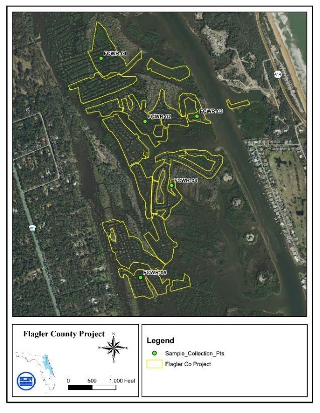 Map showing sites sampled for organochlorine pesticides |
||||||||||||||||||
| 120 | Other | Dragline ditch restoration was last attempted in 2015, yet equipment failure halted the project. How do you declare an incomplete job a success? And what would define failure? The 2015 project also resulted in the net loss of almost 300 acres of public lands. How did this happen? I thought funding was restricted to public lands exclusively. | Success depends on the goal. If the goal is to restore the health, functionality and resilience of coastal wetlands, then each step in that direction is a success. The Indian River Lagoon has enjoyed over 600 acres of those successes. It is true that equipment failure prevented a contract for restoration work from being fully performed, but the restoration work up to that point was not affected. It is not clear what lost acres are referenced by the question. However, between March 2010 and April 2015, salt marsh restoration work was performed on a little less than 48 acres of what were mistakenly identified as public lands. |
||||||||||||||||||
| 119 | Revegation | In 2015 the NSF "national science foundation" published their findings that grass planting change boosts coastal wetland success by as much as 300% by seasons end by clumping newly planted marsh grasses next to each other. Why do you still adhere to the old forestry-based practice of doing nothing knowing there is a better way? | The partners have never considered planting as a critical component of the approach. Initial revegetation through natural recruitment happens very quickly, typically within a few months. As an example, similar sites at the Merritt Island National Wildlife Refuge had 10 to 30 percent cover by six months and 50 to 80 percent cover by 18 months (Donnelly, M., Effects of biotic interactions on coastal wetland communities with applications for restoration. Ph.D. dissertation, 2014, University of Central Florida). Responses may vary due to weather, availability of plants to recruit to the area and other factors not related to the restoration process. Overall, the approach seeks to follow the advice of A. Clewell encapsulated in the excerpt below (Clewell, A. F. and J. Aronson. 2013. Ecological restoration: principles, values, and structure of an emerging profession 2nd edition, Island Press, Washington D.C.): "Reconstruction of this sort becomes necessary when natural resilience is depleted and biophysical elements of the ecosystem need replacement before recovery can be expected within acceptable time limits. Prach et al. (2007) explained that technical solutions sometimes can be implemented by the sequential removal of barriers to species establishment. Initially, removal of these barriers filter out impediments to the recovery posed by the physical environment or to the dispersal of species. As recovery proceeds, barriers in terms of competition and other biotic interactions are removed. Technical solutions attempt to remove all of these barriers. It is to be noted, however, that a recent survey of over 1,500 wetland restoration projects showed that restorationists sometimes apply more technical effort at a site than needed (Moreno-Mateos and Aronson, in review). This practice increases costs and threatens ecological effectiveness. A lesson imbedded here is that sometimes less is more, and it needs to be considered on a site-specific basis." The study mentioned above was a small-scale experiment to test the hypothesis that marsh grasses may benefit from being planted in clumps (Silliman, B.R., et al. 2015. Proceedings of the National Academy of Sciences of the United States of America 112: 14,295-14,300). Note that the 300% increase refers to overall changes, with the differences between the clumped and dispersed experimental plots being less than that value. Nevertheless, the results point to an interesting possibility that should be tested in places where planting is done. Note the guidance taken from the article and included below: "The differences in the effects of clumping and the mechanisms of facilitation between Florida and The Netherlands also suggest that the extent to which clumping may enhance marsh restoration success varies across regions. In natural communities, positive interactions have been shown to be more prevalent in arid and tropical regions where drought and heat stresses are often high (32). Moreover, natural, self-organized patchiness is most prevalent in ecosystems in dry (51, 52), cold (52), or intertidal regions (52, 53), where there are significant environmental constraints on organism growth and establishment (54). We therefore suggest that restoration experiments from a broader range of ecosystems are required to further determine the regions where the effects of clumped configuration are likely to be beneficial to restoration practices (e.g., in salt marshes in arid environments, such as southern California, alleviation of salt stress may emerge as the primary mechanism underlying the positive effects of clumping)." For this project, nearby homeowners have expressed an interest in planting, and the partnership is attempting to accommodate this request. Portions of the restored wetlands may be revegetated, thanks to a commitment from partners to provide appropriate plant material. Volunteers will be solicited to participate in the replanting, with a focus on areas adjacent to residences along the west side of the project. In addition, we will consider testing the technique of clumping grasses as recommended in the article. |
||||||||||||||||||
| 118 | Mangroves | In 2011 Ron Brockmeyer co-wrote: Coastal wetland management in Florida. He writes that in mangrove dominated areas the necessary modifications cannot be constructed through the thick tangle of mangrove roots without causing extensive environmental damage. This project looks like a Mangrove forest so how can you proceed after receiving an award for this very article? | The full quotation (see below) makes it clear that implementing some standard techniques to reduce sources of mosquitos are hampered in areas dominated by mangroves. The quote does not refer to restoring coastal wetlands. In fact, the same publication outlines the procedures and benefits of remediating the effects of dragline-impacted coastal wetlands (see below and Rey, J.R., et al. 2012 Coastal wetland management in Florida: environmental concerns and human health. Wetland Ecology and Management 20: 197–211): "In Florida, the presence of large expanses of mangroves is also an important difference from herbaceous salt marshes further north. In many cases, the thick mangrove canopy prevents or retards the delivery of aerially applied mosquitocides to the larval habitats. Additionally, some source reduction techniques, such as Open Marsh Water Management (OMWM) utilized successfully for mosquito control elsewhere, are difficult or impossible to implement in mangrove-dominated areas because the necessary modifications (ponds, pond radials, tidal ditches, etc.) can not be constructed through the thick tangle of mangrove roots and trunks without causing extensive environmental damage." "Rehabilitation of dragline ditch-impacted coastal wetlands was initiated in 1999 as a pilot project with the cooperation of VCMC, SJRWMD, and Canaveral National Seashore. The project was designed to evaluate several equipment and technique options on 22.5 ha of ditched wetland. Successful techniques developed in the pilot project have been applied to ongoing work in Mosquito Lagoon. These techniques were also implemented in Tomoka State Park. Dragline ditch restoration requires the use of an amphibious excavator. An excavator is mounted on tracked pontoons, enabling it to cross submerged areas. Two of these low bearing weight machines (less than 2 lbs/sq. in.) are owned and operated by VCMC. Vegetation is cleared from the spoil area and placed in the adjacent ditch. This process avoids burning the plants and permanently sequesters the carbon they contain. Spoil material is first moved to the small side ditches (as seen in the top image of Fig. 2, between the spoil piles). If additional material remains, the main ditch is narrowed. The area of the spoil pile and the newly filled ditch are carefully graded to the adjacent remaining wetland elevation. The result is that substantially more area is at coastal wetland elevation without the return of substantial mosquito production (Fig. 2). 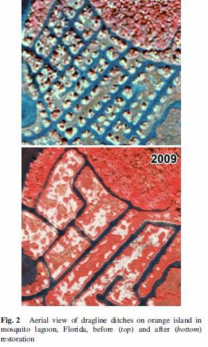 Fiddler crabs (Uca spp.) are the first animals to recruit to the newly restored surface within days. This semi-terrestrial wetland native can reach very high numbers and is food for numerous other animals, such as wading and shorebirds, fish and mammals (Montague 1980). Mangroves and other wetland plants quickly colonize the area, though it will take several years to reach near full coverage (M. Donnelly, personal communication, 2011). Restoration work has been restricted to public lands with management objectives that include restoration of impacted wetlands. Experience has shown that focusing on public lands greatly simplifies permitting issues. Restoration priorities outlined in a State approved plan (e.g., Surface Water Improvement and Management (SWIM) Plans) are eligible for Noticed General Permits from the State. These projects are also eligible for Nationwide Permits from the Army Corps of Engineers. To date, more than 132 ha of dragline ditch-impacted wetlands in the IRL system have been addressed, returning approximately 49 ha to wetland elevation." |
||||||||||||||||||
| 117 | Water quality | Are these restoration efforts being performed in an attempt to delay having to address the real issues with water quality? | The Florida Department of Environmental Protection (FDEP) takes the lead on addressing water quality through an evaluation that is applied throughout the state. Impairments are based on data collected in the relevant waterbody, and confirmed impairments are addressed by local stakeholders during development and adoption of a total maximum daily load (TMDL), which represents the load of contaminants that the system can assimilate without showing signs of impairment. A plan to achieve the relevant reductions, termed a Basin Management Action Plan (BMAP), also is developed and adopted. An alternative is for stakeholders to develop a Reasonable Assurance Plan (RAP) before impairment is confirmed. Restored wetlands add to these efforts to improve water quality by taking up nutrients that cause impairment. The waterbody at the proposed site for restoration was declared impaired due to repeated, high annual mean concentrations of chlorophyll in June 2018. At this time, FDEP has decided to reevaluate the area in the next five-year cycle, while they implement the process in the waterbody just to the north. Ultimately, the best choice is not to restore wetlands or address sources of nutrients but rather to restore wetlands and address the sources of nutrients. |
||||||||||||||||||
| 116 | Water quality | If the St. Johns Water Management District's role to the stakeholders is to manage water quality, they why aren't they addressing the root cause of water quality issues caused by nutrient loading via septic systems, city off-loading of waste water, fertilizers, pesticides, etc? Why would taxpayer money be going towards restoration efforts that will never be truly successful until the real issues with water quality are first addressed at the source? | The mission of the St. Johns River Water Management District is "to protect our natural resources and support Florida's growth by ensuring the sustainable use of Florida's water for the benefit of the people of the District and the state." To achieve this goal, the district's daily work is focused on four main core missions: water quality, water supply, flood protection and natural systems. These core missions guide the work of the district's staff for the benefit of all residents in the district's 18-county service area. Restoring degraded and degrading wetlands contributes to three of the four core areas: water quality, flood protection and natural systems. Water quality is addressed in close cooperation with the Florida Department of Environmental Protection through an evaluation that is applied throughout the state. Impairments are based on data collected in the relevant waterbody, and confirmed impairments are addressed by local stakeholders during development and adoption of a total maximum daily load (TMDL), which represents the load of contaminants that the system can assimilate without showing signs of impairment. A plan to achieve the relevant reductions, termed a Basin Management Action Plan (BMAP), also is developed and adopted. An alternative is for stakeholders to develop a Reasonable Assurance Plan (RAP) before impairment is confirmed. Restored wetlands add to these efforts to improve water quality by taking up nutrients that cause impairment. Ultimately, the best choice is not to restore wetlands or address sources of nutrients but rather to restore wetlands and address the sources of nutrients. |
||||||||||||||||||
| 115 | Monitoring | In the last workshop it was stated that there is 10% in the budget for monitoring and the question was asked if that budget would be used to engage an outside/third party source (third party not currently associated with the project team)? The answer was "No. We obtained the grant to fund restoration. Nevertheless, we are working with our partners to develop a viable plan for monitoring key components of the system." Wouldn't that be a conflict of interest to monitor yourself? Is the 10% budge adequate to cover an outside source, other than the current team associated with the project? | The 10% of total funding that can be requested through the National Coastal Wetland Conservation Grants Program was not included in our grant. We are working to develop a rigorous and viable plan to sample after restoration. The work will likely involve multiple players, including volunteers and paid participants. The results of any sampling will be made available. |
||||||||||||||||||
| 114 | Science | We have become aware that Option #11- Dragline Ditch Restoration was removed from the recent Reasonable Assurance Plan (RAP) in Mosquito Lagoon. It appears the reason it was removed was due to the lack of site specific & local research. There has been no site specific, local research done at the current prospective project site. Why are you continuing to promote this type of restoration and putting our area at risk without site specific research? | The option was removed because quantitative estimates of nutrient removal were not available for Mosquito Lagoon. There was and remains strong support for the concept that wetlands moderate water quality, as the following extract from the relevant report demonstrates (Jones Edmunds & Associates, Inc. and Janicki Environmental, Inc. 2018. Mosquito Lagoon Reasonable Assurance Plan (RAP) pollutant load-reduction projects report): "2.11 OPTION 11: DRAGLINE DITCH RESTORATION Draglines were used several decades ago to cut deep, wide ditches in the estuarine wetlands. The spoil was piled in mounds between the ditches. Dragline ditching altered the topography and bathymetry in a way the left areas that typically had been inundated by high-tide and dry during low-tide either always dry or always wet. The mounded spoils areas that are now almost always dry are prone to invasive plants. The deeper areas that are now always wet have typically not recruited saltwater marsh vegetation, leaving a bare sand bottom. SJRWMD and Volusia County have been restoring dragline ditches in the Mosquito Lagoon. An abundance of research suggests estuarine wetlands remove nutrients. With approximately 1,300 acres of dragline ditch recently restored or planned for restoration, the nutrient reduction benefit to Mosquito Lagoon from the restoration efforts may be significant. Currently, the Basin Management Action Plan process does not provide a reduction credit for dragline ditch restoration. The purpose of this option is to propose a defensible method for estimating nutrient reduction benefits from dragline ditch restoration and to quantify the nutrient load reduction from the approximately 1,300 acres of recently restored or planned restoration. We reviewed more than 50 sources and found nine with potentially useful information. We are defining useful information in part as denitrification rates for salt marshes or unvegetated estuarine areas expressed in units of mass per area per time. Despite variability in the findings across the sources, the general consensus is that the presence of saltmarsh vegetation significantly increases the rate of denitrification (Caffrey and Kemp, 1990) and likely results in long-term sequestration or sedimentation of nutrients. Other pathways of increased nutrient uptake in saltwater marshes were not considered for this effort because whether they offer a significant long-term net reduction in available nutrients is not clear or the literature sources contained greater variability (e.g., anammox). Additionally, long-term double-counting of sedimentation and denitrification is possible if a major source of denitrification is in the sediment. Conservatively, we are proposing the credit to be the increased denitrification taken from literature values between an unvegetated bottom and saltmarsh vegetation. Future research may support a higher credit, but a conservative approach is currently more defensible. Unfortunately, literature sources with useful information were generally from study areas outside Florida. The difference in conditions makes how transferable the results of these studies are to the Mosquito Lagoon questionable. In discussions with Florida Department of Environmental Protection (FDEP) on this subject, they believe that using Florida-based values or values from systems that are demonstrably similar to the Mosquito Lagoon is important to have reasonable assurance that the values are appropriate. In part to explore how valuable research to achieve this may be, we used literature values to estimate increases in denitrification rates in restored dragline ditches. The most comprehensive review of denitrification rates we found was documented in Measurements of Denitrification in Aquatic Ecosystems: Literature Review and Data Report (S.E. Green, 2005). One of the tables in this document provides statistics (min, max, mean, median, range, and n) of denitrification rates grouped by type. The mean and median denitrification rates for estuaries listed in this report are 197 and 40 μmol N m-2 h-1, respectively, with a sample size of 1,188. The respective values for mudflats, which is the closest category to dragline ditch areas but likely different in terms of denitrification rates, are 71 and 31 μmol N m-2 h-1, respectively, with a sample size of 61. The report does not provide enough information to ascertain the distribution of the data; therefore, we do not know if mean or median is the better statistic for central tendency. To explore the potential importance of dragline ditch restoration for pollutant load reduction in Mosquito Lagoon, we used the difference between the medians of the rates listed above (40 μmol N m-2 h-1 minus 31 μmol N m-2 h-1, since that difference was the smaller of the two) and multiplied it by 1,300 acres. That resulted in a TN reduction of 12,800 lb./yr. The magnitude of that number suggests that research into denitrification rates specific to restored and unrestored dragline ditches in Mosquito Lagoon may be very valuable for restoration efforts." We have no evidence that your area is being put at risk, as shown by a series of analyses (See Appendices Effects on Water Levels and Waves, Effects on Water Quality, Effects on Oysters, Effects on Fish, and Effects on Vegetation, Fiddler Crabs and Birds), which demonstrate that the process does not adversely affect flooding, water quality, oysters, fiddler crabs, fish or birds. |
||||||||||||||||||
| 113 | Water quality | According to your answer regarding water impairment, the Florida Department of Environmental Protection has determined the area to be impaired. However, the areas that they took water samples from were at the 100 Bridge and High Bridge, not within the specific project area. Also, those are both areas that are next to sewage outflows from Flagler Beach and high traffic boating areas. Even so, per the results shown by the DEP, the Chlorophyll A levels have been continually declining and, given a few more years, will be back to acceptable levels. What will happen during the lag time for vegetation regrowth, if you remove the current vegetation that has been effectively filtering these very waterways? How will that effect our water quality during that period of time? | The area is not pristine or fully functioning. The wetland that existed was degraded by being ditched, and conditions continue to degrade, including conversion of wetland to open water at the rate of about 1 acre per year (see Appendix Continued Degradation). In addition to continued loss of valuable wetland, the waters in the area were declared impaired by the Florida Department of Environmental Protection (FDEP) in June 2018. The impairment is based on evaluating concentrations of chlorophyll-a, which correlate with the amounts of single-celled algae in the water. Data were collected at three sites in the area (see Appendix Impaired Water Quality), with the two northern sites being essentially the same as where the stakeholders' consultant collected water (see 1:29:00-1:29:16 of the video from the meeting on Nov. 7, 2018, https://stg-sjrwmd-test.kinsta.cloud/facts/flagler-wetland-restoration-project/#narrative-construction-methods). Average concentrations of chlorophyll-a in the water exceeded the target concentration by approximately 2-3 times over the last 13 years. Algae require nutrients, so the impairment can be attributed to nitrogen and phosphorus from wastewater discharges, stormwater runoff, leachate from septic tanks, and other sources. The impairment will be reassessed in the next five-year cycle. Eventually, local stakeholders, such as the city of Flagler Beach and Flagler County, may participate in development and adoption of one or more total maximum daily loads (TMDLs), which represent the loads of contaminants that the system can assimilate without showing signs of impairment. A plan to achieve nutrient reductions, termed a Basin Management Action Plan (BMAP), also will be developed and adopted. Restored wetlands add to these efforts to improve water quality by taking up nutrients that cause the impairment. Ultimately, the best choice is not to restore wetlands or address sources of nutrients but rather to restore wetlands and address the sources of nutrients. Concerns about detrimental effects of restoration on water quality have been examined using a reference site approach at two scales: a short-term study focused on an area being restored and a longer term look at data on a regional scale (see Appendix Effects on Water Quality). In both cases, key parameters were turbidity and concentrations of dissolved organic carbon (DOC), dissolved phosphorus (DP), dissolved ammonium combined with dissolved organic nitrogen (termed dissolved Kjeldahl nitrogen, DKN), and chlorophyll-a (an indicator of algal blooms). There was no evidence of adverse effects from restoration in either analysis. |
||||||||||||||||||
| 112 | Construction | We understand Pontoon boats will be used for the refueling of the Excavator. What will the draft be of the pontoon boat with the extra weight of the fuel? What are the EPA and/or OSHA guidelines for refueling and do you have a plan in place to remediate any accidental leaks or spills? If so, we would like a copy of that action plan. | Our contractor states: "Perry Construction Co., Inc has demonstrated the ability to perform aquatic vegetation and associated sediment removal projects in many bodies of water throughout Florida over the past 32 years. We approach each project with the attitude necessary to exceed all project requirements public and/or private. Our personnel have been trained & certified in containment, immediate notification to the appropriate agency (FWC, EPA, Coast Guard, FDEP, etc.). Our employees receive certified training for Hazardous Materials Operations/OSHA Level II." Based on many variables, we do not know what the draft of the pontoon boat will be for the added weight of the fuel. UPDATE: The District has approved the contractor’s request to use a second excavator. The new excavator will be brought into the project area on or after June 13, 2019. The second excavator will help to expedite completion of the project and finishing more segments during the growing season should also help the restored wetlands revegetate sooner. The second excavator is an amphibious Caterpillar 312D, which is slightly smaller than the Caterpillar 320D already in use. |
||||||||||||||||||
| 111 | Fish, Construction | Will Fish/Wildlife/Aquatic life be killed during the process of this project? Yes or No? | We must comply with specific permit conditions related to certain organisms, such as protected species. Fish are mobile and able to avoid grading of spoil. Birds also tend to leave the immediate area, but some remain. Since the work will focus on spoil areas above wetland elevation and the material will be placed in an adjacent ditch, a limited number of invertebrates will be impacted. However, the resulting restored surface will expand the habitat available to most of these organisms, especially aquatic ones. |
||||||||||||||||||
| 110 | Science, Other | Why are you attempting to perform restoration work in an area that, other than the fact it had been dragline ditch years ago, is NOT impaired and in need of restoration when there are many areas within the District's jurisdiction that are in desperate need of funding? | The site was identified as suitable for restoration prior to 2007, when all disturbed coastal wetlands between Jacksonville and Ponce de Leon Inlet were mapped. Staff used these maps to identify a publicly owned site to support a request for an extension of a grant from the U.S. Fish and Wildlife Service (USFWS) that was submitted in mid-2017. The site in southern Flagler County was identified as a possible candidate by the St. Johns River Water Management District because it met key criteria, including it was degraded due to ditching in the 1960s and 1970s, it was undergoing further degradation as the remaining patches of wetland convert to less productive open water, it was on publicly owned land, and it was just north of an area where previous restoration had been successful. The area is not pristine or fully functioning. The wetland that existed was degraded by being ditched, and conditions continue to degrade, including conversion of wetland to open water at the rate of about 1 acre per year (see Appendix Continued Degradation). In addition to continued loss of valuable wetland, the waters in the area were declared impaired by the Florida Department of Environmental Protection (FDEP) in June 2018. The impairment is based on evaluating concentrations of chlorophyll-a, which correlate with the amounts of single-celled algae in the water. Data were collected at three sites in the area (see Appendix Impaired Water Quality), with the two northern sites being essentially the same as where the stakeholders' consultant collected water (see 1:29:00-1:29:16 of the video from the meeting on Nov. 7, 2018, https://stg-sjrwmd-test.kinsta.cloud/facts/flagler-wetland-restoration-project/#narrative-construction-methods). Average concentrations of chlorophyll-a in the water exceeded the target concentration by approximately 2-3 times over the last 13 years. Algae require nutrients, so the impairment can be attributed to nitrogen and phosphorus from wastewater discharges, stormwater runoff, leachate from septic tanks, and other sources. The impairment will be reassessed in the next five-year cycle. Eventually, local stakeholders, such as the city of Flagler Beach and Flagler County, may participate in development and adoption of one or more total maximum daily loads (TMDLs), which represent the loads of contaminants that the system can assimilate without showing signs of impairment. A plan to achieve nutrient reductions, termed a Basin Management Action Plan (BMAP), also will be developed and adopted. Restored wetlands add to these efforts to improve water quality by taking up nutrients that cause the impairment. Ultimately, the best choice is not to restore wetlands or address sources of nutrients but rather to restore wetlands and address the sources of nutrients. |
||||||||||||||||||
| 109 | Monitoring | To prove any project a success or failure, proper study and research should to be done in that specific area before and after using set, standard protocols consistently. Where is the documentation from previous project sites showing water quality (pre and post), fish counts specific to the project area (pre and post)? Have any studies been performed in the previous project sites routinely and how long do you monitor these sites afterwards? | Before-and-after monitoring is one way to evaluate restoration projects, but the results of such efforts can be confounded by changes at larger spatial scales. For example, the first year after restoration may be a bad year for fish throughout the Halifax River for various reasons unrelated to the project, and a simple before-and-after comparison could lead to the mistaken conclusion that restoration lowered the abundance of fish. Another approach that reduces such confusion is to compare restored sites and nearby undisturbed reference sites, which is the approach that we have taken (see Appendices Effects on Oysters, Effects on Fish, and Effects on Vegetation, Fiddler Crabs and Birds). In all cases the analyses provided proof of the value of our approach. Sampling at three restored sites and one undisturbed site showed that cover of plants rebounded within approximately two years. Furthermore, data on oysters, fiddler crabs, fish and birds indicated that restoring wetlands by grading them to the appropriate elevation yields systems that come to resemble undisturbed areas. |
||||||||||||||||||
| 108 | Water Quality, Fish, Other | We have heard from a multitude of people that the fishing has been ruined in some of the previous project areas and the water quality has not improved. Instead of spending taxpayer money on further projects, why can't those funds be taken back to the areas that are still struggling in Volusia County? | Again, we do not have access to records of your interactions with these stakeholders. We can refer to records of inquiries submitted to us or the Florida Department of Environmental Protection (see below), and we offer an analysis of fish abundance based on standardized sampling in the area of the project and in Mosquito Lagoon where previous areas were restored (see Appendix Effects on Fish). In the last decade, we have responded to inquiries from eight individuals or couples regarding work near Bethune Beach and Oak Hill. Six of the eight inquiries were related to two unsuccessful lawsuits and the other two inquiries were resolved using the same approach being employed for this project. The other two inquiries were resolved using the same approach being employed for this project. Conversations with the concerned citizens and a field visit resulted in the emails provided below (note Dr. Tom Lee is a retired oceanographer). See question # 14 above for the email correspondences. In terms of potential detrimental effects on fish, the district sponsored sampling of fish in the region by the U.S. Geological Survey from 2002-2004 (Turtora, M. and Schotman, E.M., 2010. Seasonal and spatial distribution patterns of finfish and selected invertebrates in coastal lagoons of northeast Florida: 2002-04. U.S. Geological Survey Scientific Investigations Report 2010-5131, see Appendix Effects on Fish). Collections in the project area focused mostly on the main stem of the Intracoastal Waterway and some large creeks. In general, the project area zone is similar to other zones to the north and south in terms of fish species occurrence and abundance. Data from seining yielded 145 species that also were caught with the same method in Mosquito Lagoon. Thus, an analysis of data from Mosquito Lagoon is relevant to the area to be restored, and such an analysis can examine the effects of the restoration that was completed in Mosquito Lagoon (see Appendix Effects on Fish). The analysis detected variation in the numbers of animals caught, but the mean numbers of some common and valued fish and invertebrates did not vary in a consistent spatial or temporal pattern relative to restoration. When considering the effects of restoring ditched wetlands on fish populations, it is important to separate short-term effects and long-term effects, which will be influenced by a variety of factors other than restoration of wetlands. Functional wetlands produce food and provide habitat that ultimately support a variety of fish, with an estimate for a restored wetland in northern Brevard County being 50 pounds of fish per acre (Stevens, P.W., et al. 2006. Fate of fish production in a seasonally flooded saltmarsh. Marine Ecology Progress Series 327: 267-277). Moreover, research provides strong evidence that coastal marshes are preferred or essential habitats for key life stages of most fishery species in Florida (Seaman, W., ed., 1985. Florida aquatic habitat and fishery resources. Florida Chapter of American Fisheries Society). A review paper analyzing the eastern U.S. and Gulf shows that commercial landings of estuarine-dependent species on a unit area basis correlates with the ratio of marsh area/open water for many estuaries other than the unique Chesapeake Bay system (Nixon, S., 1980. Between coastal marshes and coastal waters-a review of twenty years of speculation and research on the role of saltmarshes in estuarine productivity and water chemistry. Estuarine Wetland Processes, Plenum Press). In fact, blue crab populations directly relate to wetland area in Florida (Seaman, W., ed., 1985. Florida aquatic habitat and fishery resources. Florida Chapter of American Fisheries Society). In addition, according to a study of 27 smooth cordgrass/black needlerush/mangrove locations worldwide, edible shrimp production is directly related to the area of wetland vegetation and not the area, average depth or volume of estuaries themselves (Turner, R., 1977. Intertidal vegetation and commercial yields of penaeid shrimp. Transactions of the American Fisheries Society 106: 411-416). Nevertheless, fish and other top predators tend to get food from multiple sources. Because it requires years for restored areas to recruit plants and build a similar habitat structure and productivity to natural marshes, research shows a lag time for ecosystem services to respond (Craft, C., et al.1999. Twenty-five years of ecosystem development of constructed Spartina alterniflora marshes. Ecological Applications 9: 1405-1419). Thus, restoring wetlands may not yield an immediate and obvious increase in fish, but it represents a sensible and proven strategy to safeguard fish populations in the long term. |
||||||||||||||||||
| 107 | Fish, Other | There was a meeting on October 17th with a few local fishing guides and the team members. Why did you misrepresent the local fishing guides position on the project? | Our response to the question asked by a member of the public is what six members of the project team who attended the meeting remember as being accurate. We recognize that the local fishing guides who met with project partners on Oct. 17 do not support implementation of the project as proposed at the Nov. 7 meeting, which was stated by Capt. Chris Herrera. To see the question and our response, please visit the frequently asked questions at this site: https://stg-sjrwmd-test.kinsta.cloud/facts/flagler-wetland-restoration-project/. |
||||||||||||||||||
| 106 | Other | The District has stated that "Successful projects also have been completed near Oak Hill, Bethune Beach, Edgewater, and Ormond Beach. Like this proposed site, each had a mix of intact and impacted areas. Previous restoration has not adversely affected adjacent areas." Why have we heard from many stakeholders, within those different project sites, who state the complete opposite and have had terrible, negative experiences of what they were left with after the project was completed? | We do not have access to records of your interactions with other stakeholders, but we can refer to records of inquiries submitted to us or the Florida Department of Environmental Protection. In the last decade, we have responded to inquiries from eight individuals or couples regarding work near Bethune Beach and Oak Hill. Six of the eight inquiries were related to two unsuccessful lawsuits and the other two inquiries were resolved using the same approach being employed for this project. Conversations with the concerned citizens and a field visit resulted in the emails provided below (note Dr. Tom Lee is a retired oceanographer): Email # 1: From: William Greening [mailto:wgreening@co.volusia.fl.us] Sent: Wednesday, December 16, 2009 10:15 AM To: Laura Herren; Brockmeyer Ron Sent: Friday, July 2, 2010 2:00 PM To: Ron Brockmeyer Cc: Colleen Castille Subject: Mosquito Lagoon Salt Marsh Restoration Project Ron, Paul and Bill, Thank you so much for the taking the time to give me a detailed site inspection tour of ongoing and past efforts to restore the salt marsh in the northern part of Mosquito Lagoon. It was a fantastic tour that was only made possible by air boat. I have a much greater understanding of the project now and feel that it is scientifically well throughout and has a high probability of achieving the desired goal of increasing the salt marsh acreage by 50 to 80%. Dragline ditching for mosquito control in the 1940's and 50's has created large areas of parallel shallow ditches with small spoil mounds placed on the adjacent marsh. The combination of ditched and spoil mound area has greatly reduced total area of salt marsh and in addition the spoil mounds allow for the establishment of invasive plant species, like Brazilian pepper. Removing the spoil mounds and packing the vegetation and sand spoil down into dead-end finger canals left between spoil mounds by the original ditching appears to be a simple and feasible method to increase salt marsh habitat while maintaining the tidal water flow in the shallow ditches which is necessary not only for mosquito control but to provide access to nursery grounds for juvenile fish including red fish, trout, snook, flounder and mullet. I originally had misgivings about the techniques being used with the amphibious excavator equipped with a hydraulic backhoe to remove the spoil mounds. When one first looks at a recently excavated site it leaves a terrible feeling of destruction of marsh and mangrove. But when you understand that the spoil mounds and their vegetation have been buried and spread precisely into the dead-end finger canals and graded to marsh elevation to encourage the reestablishment of the marsh grasses and mangroves then it becomes clear that the end result will be greater area of salt marsh without lessening the mosquito control function of the remaining ditches. This is a worthy goal and inspection of completed project sites nearby clearly show that the reestablishment of the salt marsh begins immediately and is well underway in only a few years and by 10 years it is a fully functioning salt marsh. In 20 years it would be difficult to detect any disruption in the marsh habitat. I was also encouraged to learn that site selections are carefully determined and that isolated spoil mounds or mounds close to upland areas are not planned to be removed. Removal is planned only for mound areas that will produced significant salt marsh area. So thank you again for a great day and for giving me the opportunity to learn more about this worthy project. Sincerely, Tom Lee |
||||||||||||||||||
| 105 | Construction, Science | Based on the findings of the Society for Ecological Restoration Publication: Guidelines for Developing and Managing Ecological Restoration Projects by Andre Clewell, John Rieger, & John Munro "Management actions that cause ecological damage do not qualify as restoration. Unfortunately, restoration is applied inappropriately to projects that sacrifice biodiversity and impair ecological functions to accomplish single-species management or to attain economic objectives. Restoration projects can accommodate particular species and can satisfy economic objectives as long as ecosystem integrity is not compromised." The group of scientists with the Army Corp of Engineers, no doubt, thought they were doing a good thing in their efforts to control mosquitos when creating the dragline ditches. Through years of natural succession, this area transformed itself back to a fully functioning habitat that supports every creature and plant life that is necessary for a flourishing estuary to thrive. How can this project be labeled a restoration when all that is being done is to bulldoze over mature vegetation, bury it in the water, and leave the area to fend for itself all over again? If the funding was available, would you utilize different methods to achieve the end result goal? | According to Clewell and Aronson (Clewell, A. F. and J. Aronson. 2013. Ecological restoration: principles, values, and structure of an emerging profession 2nd edition, Island Press, Washington D.C.), restoration strives to "restore ecological continuity," which means restoring function. In this context, elevation is the critical component for re-establishing functional saltmarsh habitat. Restoration is needed because the area is not pristine or fully functioning. The wetland that existed was degraded by being ditched, and conditions continue to degrade, including conversion of wetland to open water at the rate of about 1 acre per year (see Appendix Continued Degradation) and elevated concentrations of chlorophyll-a (see Appendix Impaired Water Quality). The approach does not focus on a single species or economics, but rather on getting the elevation correct so that the area returns to as near its original ecological trajectory as possible. This approach has included letting plants recruit naturally, which reduces any bias in the plant assemblage, any damage to the restored area and cost. Please note that the approach as applied here and as applied in the past has garnered funding through a national competition and won a national award, with selection being made by a widely representative committee (see description below taken from http://elinwa.org/about-nwas and http://elinwa.org/awards/recipients/ron-brockmeyer). In fact, the approach addresses some key issues presented in Clewell, A. F. and J. Aronson. 2013. Ecological restoration: principles, values, and structure of an emerging profession 2nd edition and all 51 steps in the Guidelines for Developing and Managing Ecological Restoration Projects (see Appendix Society for Ecological Restoration). "The National Wetlands Awards are presented annually to individuals who have excelled in wetlands protection, restoration, and education. Through coordinated media outreach, educational events, and an awards ceremony on Capitol Hill, awardees receive national recognition and attention for their outstanding efforts. The program is administered by the Environmental Law Institute (ELI) and supported by the U.S. Environmental Protection Agency, U.S. Fish and Wildlife Service, U.S. Forest Service, Natural Resources Conservation Service, NOAA Fisheries, and the Federal Highway Administration. ELI coordinates the awards program, while our federal agency supporters provide financial support, serve on the selection committee, and/or participate in the ceremony." "The awardees are selected by a widely representative committee composed of 10-15 wetlands experts from around the country, including representatives from each federal supporting agency, members of the conservation and business communities, and representatives from state and local governments. Selection Committee members are carefully selected to represent a diversity of geographic areas and wetland expertise. ELI facilitates the Selection Committee meeting, but does not participate in selecting the winners." "Ron Brockmeyer, coastal wetland program manager for St. Johns River Water Management District, has led efforts with federal, state, and local partners over the past 18 years to rehabilitate more than 20,000 acres of severely impacted coastal wetlands in east central Florida. His work has focused on restoring the impacts of decades of salt marsh mosquito control dragline ditching and impoundments, working to reconnect wetlands and remove hydrologic restrictions like dikes and spoil. Ron has also led the development of a monitoring program to determine the effectiveness of this restoration work. In addition, Ron has a leading role in developing the regional coastal habitat restoration plan for northeast Florida and has served as the project coordinator for a multiagency, interdisciplinary wetlands research effort, which is designed to evaluate restoration and management options for coastal wetlands. Ron's coastal wetlands rehabilitation work is considered the most beneficial natural resource restoration activity in the Indian River Lagoon ecosystem, an Estuary of National Significance." |
||||||||||||||||||
| 104 | Other | Stakeholders have asked if there is or will be an Economic Impact Study and a Property Value Study done and were told "No" to both. Why wouldn't you perform these studies seeing as the end result of this project could greatly impact both? | The plans do not impact either issue directly. All work will be on state lands, and part of that work was included in an approved management plan (Florida Department of Environmental Protection. 2018. Gamble Rogers Memorial State Recreation Area at Flagler Beach Acquisition and Restoration Council Draft Unit Management Plan, https://floridadep.gov/parks/parks-office-park-planning/documents/gamble-rogers-memorial-state-recreation-area-flagler-0). In addition, there is no tangible evidence of long-term detrimental effects. Initial revegetation through natural recruitment happens very quickly, typically within a few months. As an example, similar sites at the Merritt Island National Wildlife Refuge had 10 to 30 percent cover by six months and 50 to 80 percent cover by 18 months (Donnelly, M., Effects of biotic interactions on coastal wetland communities with applications for restoration. Ph.D. dissertation, 2014, University of Central Florida). Responses may vary due to weather, availability of plants to recruit to the area and other factors not related to the restoration process. Overall, the approach seeks to follow the advice of A. Clewell encapsulated in the excerpt below (Clewell, A. F. and J. Aronson. 2013. Ecological restoration: principles, values, and structure of an emerging profession 2nd edition, Island Press, Washington D.C.) "Reconstruction of this sort becomes necessary when natural resilience is depleted and biophysical elements of the ecosystem need replacement before recovery can be expected within acceptable time limits. Prach et al. (2007) explained that technical solutions sometimes can be implemented by the sequential removal of barriers to species establishment. Initially, removal of these barriers filter out impediments to the recovery posed by the physical environment or to the dispersal of species. As recovery proceeds, barriers in terms of competition and other biotic interactions are removed. Technical solutions attempt to remove all of these barriers. It is to be noted, however, that a recent survey of over 1,500 wetland restoration projects showed that restorationists sometimes apply more technical effort at a site than needed (Moreno-Mateos and Aronson, in review). This practice increases costs and threatens ecological effectiveness. A lesson imbedded here is that sometimes less is more, and it needs to be considered on a site-specific basis." |
||||||||||||||||||
| 103 | Permitting | An Environmental Assessment is a concise public document that serves to provide sufficient evidence and analysis regarding the significance of environmental impacts of the proposed action and to provide alternatives to that proposal to aid in decision-making when there is an unresolved conflict in the use of resources. An EA must address and document those areas where there is a potential to significantly affect the environment and provide the public an opportunity for involvement and input in the decision process in accordance with the law. Why have you not performed an Environmental Assessment? | The federal permit application process through the U.S. Army Corps of Engineers requires consultation with all appropriate federal agencies to determine all requirements. The grant review and federal permitting process determined that neither an EIS nor EA was required for this project. |
||||||||||||||||||
| 102 | Permitting | Federal laws and regulations require the federal government to evaluate the effects of its actions on the environment and to consider alternative courses of action. This document describes the impacts on the environment as a result of a proposed action. It also describes impacts of alternatives as well as plans to mitigate the impacts. Since this project is federally funded, why has there not been an Environmental Impact Statement done? | The federal permit application process through the U.S. Army Corps of Engineers requires consultation with all appropriate federal agencies to determine all requirements. The grant review and federal permitting process determined that neither an EIS nor EA was required for this project. | ||||||||||||||||||
| 101 | Revegetation | We asked if re-vegetation would be done and you previously stated that there would be no revegetation for this specific project site due to budget constraints and stating it was not a necessary procedure, however, there is now mention that there may be some revegetation that will take place. Will there be revegetation and, if so, how much vegetation will be planted and is this something that has been added to the budget? If so, can we see this in writing? | We actually said that revegetation was not needed so we applied the budget to restoring more wetland. Initial revegetation through natural recruitment happens very quickly, typically within a few months. As an example, similar sites at the Merritt Island National Wildlife Refuge had 10 to 30 percent cover by six months and 50 to 80 percent cover by 18 months (Donnelly, M., Effects of biotic interactions on coastal wetland communities with applications for restoration. Ph.D. dissertation, 2014, University of Central Florida). Responses may vary due to weather, availability of plants to recruit to the area and other factors not related to the restoration process. Overall, the approach seeks to follow the advice of A. Clewell encapsulated in the excerpt below (Clewell, A. F. and J. Aronson. 2013. Ecological restoration: principles, values, and structure of an emerging profession 2nd edition, Island Press, Washington D.C.): "Reconstruction of this sort becomes necessary when natural resilience is depleted and biophysical elements of the ecosystem need replacement before recovery can be expected within acceptable time limits. Prach et al. (2007) explained that technical solutions sometimes can be implemented by the sequential removal of barriers to species establishment. Initially, removal of these barriers filter out impediments to the recovery posed by the physical environment or to the dispersal of species. As recovery proceeds, barriers in terms of competition and other biotic interactions are removed. Technical solutions attempt to remove all of these barriers. It is to be noted, however, that a recent survey of over 1,500 wetland restoration projects showed that restorationists sometimes apply more technical effort at a site than needed (Moreno-Mateos and Aronson, in review). This practice increases costs and threatens ecological effectiveness. A lesson imbedded here is that sometimes less is more, and it needs to be considered on a site-specific basis." For this project, nearby homeowners have expressed an interest in planting, and the partnership is working to accommodate this request. Portions of the restored wetlands may be revegetated, thanks to a commitment from partners to provide appropriate plant material. Volunteers will be solicited to participate in the replanting, with a focus on areas adjacent to residences along the west side of the project. The final plan is not yet complete, but we anticipate transplanting about 5,000 plants from previously restored wetlands in Gamble Rogers State Park with the help of volunteers. Five thousand plants cover 0.5 acres if planted on 2-foot centers and 1 acre if on 3-foot centers. |
||||||||||||||||||
| 100 | Permitting, Revegetation | In previous project areas the permit requirements stated "(b) All erodible ground areas and slopes disturbed during construction shall be revegetated with sod, mulch, seed, wetland species, or otherwise appropriately stabilized within 72 hours after completion of the activity authorized under this general permit and at any other time as necessary to prevent violations of state water quality standards." Why was this requirement removed from the permit for this project? | The conditions for General Permits were revised by the Florida Department of Environmental Protection. In addition, the requirements were general requirements, which can be superseded by specifics in a given permit. The partners have never considered planting as a critical component of the approach. Initial revegetation through natural recruitment happens very quickly, typically within a few months. As an example, similar sites at the Merritt Island National Wildlife Refuge had 10 to 30 percent cover by six months and 50 to 80 percent cover by 18 months (Donnelly, M., Effects of biotic interactions on coastal wetland communities with applications for restoration. Ph.D. dissertation, 2014, University of Central Florida). Responses may vary due to weather, availability of plants to recruit to the area and other factors not related to the restoration process. Overall, the approach seeks to follow the advice of A. Clewell encapsulated in the excerpt below (Clewell, A. F. and J. Aronson. 2013. Ecological restoration: principles, values, and structure of an emerging profession 2nd edition, Island Press, Washington D.C.): "Reconstruction of this sort becomes necessary when natural resilience is depleted and biophysical elements of the ecosystem need replacement before recovery can be expected within acceptable time limits. Prach et al. (2007) explained that technical solutions sometimes can be implemented by the sequential removal of barriers to species establishment. Initially, removal of these barriers filter out impediments to the recovery posed by the physical environment or to the dispersal of species. As recovery proceeds, barriers in terms of competition and other biotic interactions are removed. Technical solutions attempt to remove all of these barriers. It is to be noted, however, that a recent survey of over 1,500 wetland restoration projects showed that restorationists sometimes apply more technical effort at a site than needed (Moreno-Mateos and Aronson, in review). This practice increases costs and threatens ecological effectiveness. A lesson imbedded here is that sometimes less is more, and it needs to be considered on a site-specific basis."For this project, nearby homeowners have expressed an interest in planting, and the partnership is working to accommodate this request. Portions of the restored wetlands may be revegetated, thanks to a commitment from partners to provide appropriate plant material. Volunteers will be solicited to participate in the replanting, with a focus on areas adjacent to residences along the west side of the project. |
||||||||||||||||||
| 99 | Construction | Since the initiation of these types of projects there have been changes in how they have been implemented moving forward. What were the standards set for success in previous project areas? What was the reasoning for changing the processes used at past project sites vs the current project site? (ie. Turbitiy screens in place longer, re-vegetation of areas) | There have not been substantial changes in the approach to restoring areas affected by ditches. Turbidity screens have been held in place for about the same amount of time, and success comprises grading to the target elevation and natural recruitment of vegetation over a period of a few years. The standard for success is area (in acres) of spoil pile and ditch converted to the target elevation, as evidenced by the recruitment of saltmarsh plant species. The standard is measured using GIS (geographic information systems) software to calculate acres converted and by ground truthing of target plant species. |
||||||||||||||||||
| 98 | Mangroves, Flooding | Per the DEP Website: Mangrove forests protect uplands from storm winds, waves and floods. The amount of protection afforded by mangroves depends upon the width of the forest. A very narrow fringe of mangroves offers limited protection, while a wide fringe can considerably reduce wave and flood damage to landward areas by enabling overflowing water to be absorbed into the expanse of forest. Mangroves can help prevent erosion by stabilizing shorelines with their specialized root systems. Given the unknown lag time of when the removed vegetation (including many mature mangroves) will regrow, what happens to adjacent homes if we are hit by a storm or weather event, after the mangroves and other protective infrastructure (ie spoil piles, mature trees, grasses) that are currently in place and serving the adjacent homes as an effective wind/surge mitigator and helped to spare many of the adjacent homes from major flooding during Hurricane Irma & Matthew? | Saltmarsh also buffers surge, as stated in quotes from additional web pages developed by the Florida Department of Environmental Protection: "These plants have extensive root systems that enable them to withstand brief storm surges, buffering the impact on upland areas. (https://floridadep.gov/fco/fco/content/salt-marshes). Salt marshes also protect shorelines from erosion by buffering wave action and trapping sediments. They reduce flooding by slowing and absorbing rainwater and protect water quality by filtering runoff, and by metabolizing excess nutrients. (https://oceanservice.noaa.gov/facts/saltmarsh.html)." In addition, we examined the potential effect of restoring degraded wetlands on water levels and waves (see Appendix Effects on Water Levels and Waves). Unlike using fill to raise the elevation of a house, the project is not adding soil to the area, so it will not force water to flow to another site. Extreme events, such as hurricanes, create storm surge, with water from the ocean forced through inlets toward the land. Data from the Federal Emergency Management Agency indicate that surges caused by Category 3 or stronger hurricanes will flood the region regardless of whether the restoration is completed, and there are no data to support the premise that the current condition has or can provide special protection from such major storms. Analysis of historical data and targeted modeling indicated that high water in the area (setup) is primarily due to water being pushed through the inlets during periods of strong winds from an easterly direction. Due to the limited fetch (the distance traveled by wind or waves across open water), winds cannot generate substantial local setup or waves as high as a foot even after the area is restored. This modeling applied standard methods used by the U.S. Army Corps of Engineers, and it was based on rather severe and unusual conditions, with 2.4 feet of water above the datum and a 36-mile-per-hour wind. Both events are predicted to occur only once every 10 years, and the setup is almost equal to the 2.5 feet predicted for Category 2 hurricanes. Furthermore, the modeling did not consider the dampening effects of shallow areas in open water (including shoals or oyster reefs) or vegetation recolonizing restored surfaces. Native plants that recruit to the area, such as wetland grasses and mangroves, will ameliorate wave energy, with research in a wave pool showing that one-year-old smooth cordgrass occurring at a density of 37 shoots per 0.25 m2 can reduce wave energy by ~32% (Manis, J., 2013. Assessing the effectiveness of living shoreline restoration and quantifying wave attenuation in Mosquito Lagoon, Florida. University of Central Florida M.S. Thesis). Additional modeling showed that a few piles of spoil along the line of fetch will reduce the waves by 50-60%. This reduction is expected to occur because some piles of spoil will not be modified during the project. |
||||||||||||||||||
| 97 | Construction, Habitat, Permitting | Per Permit requirements: File No: 18-036427-001-EG Page 10 (c) All in-water activities, including vessel operation, must be shut down if a listed species comes within 50 feet of the work area. Activities shall not resume until the animal(s) has moved beyond a 50-foot radius of the in-water work, or until 30 minutes elapses since the last sighting within 50 feet. Animals must not be herded away or harassed into leaving. All onsite project personnel are responsible for observing water-related activities for the presence of listed species. File No: 18-036427-001-EG Page 12 (e) Construction, use, or operation of the structure or activity shall not adversely affect any species which is endangered, threatened or of special concern, as listed in Rules 68A-27.003, 68A27.004 and 68A-27.005, F.A.C. Locals are aware of many unmapped oyster beds within the project area where it would be impossible to keep water flow over the oyster bars with turbidity screens surrounding them and specifically some that are in the middle of the sections mapped to be graded. Since oysters need waterflow to survive and cannot withstand heavily disturbed waters, what happens if oyster beds are discovered within/in the middle of the area mapped out to be restored? How will that determine/alter the footprint of the mapped area? | In the design phase, the partners worked from a map prepared using aerial imagery and ground truthing. The partners welcome input from residents and recreational/commercial users of the area who are familiar with any unmapped oyster beds. The project's contract ecologist also will conduct an extensive, hands-on survey of the area to identify live oyster bars and reduce the chance of accidental impacts. Aerial imagery taken with a drone may provide additional information for an update. Turbidity screens are effective at reducing the spread of particles, but they will not eliminate tidal exchange of water, so it is unlikely that they will impact the long-term survival of oyster reefs. In fact, oysters have not been negatively affected by past restoration projects (see Appendix Effects on Oysters). Ultimately, marshes typically benefit oysters because they produce detritus and particulate organic matter that oysters can eat. (Bahr, L. and W. Lanier. 1981. The ecology of intertidal oyster reefs of the south Atlantic coast. USFWS OBS-81/15). Research has shown a positive relationship between oyster production and area of saltmarsh (Dame, R., 1976. Energy flow in an intertidal oyster population. Estuarine and Coastal Marine Science 4: 243-253) and a higher yield of meat by shell volume for oysters near marshes (Manzi, J., et al. 1977. A comparison of growth and survival of subtidal Crassostrea virginica in South Carolina saltmarsh impoundments. Aquaculture 12: 293-310). |
||||||||||||||||||
| 96 | Construction, Water quality, Permitting | Per Permit Requirements: File No: 18-036427-001-EG Page 9 (11) Activities shall be conducted in a manner that does not cause or contribute to violations of state water quality standards. Performance-based erosion and sediment control best management practices shall be implemented and maintained immediately prior to, during, and after construction as needed to stabilize all disturbed areas, including other measures specified in the permit to prevent adverse impacts to the water resources and adjacent lands. Erosion and sediment control measures shall be installed and maintained in accordance with the State of Florida Erosion and Sediment Control Designer and Reviewer Manual (Florida Department of Environmental Protection and Florida Department of Transportation, June 2007) In previous project areas, revegetation was used to facilitate withholding of soil sediments. Per the project plan, "The scope of work anticipates the need to have turbidity barriers for up to two months after completion of work in each work area." However, according to the information provided it will take "10 to 30 percent cover by six months and 50 to 80 percent cover by 18 months" for natural recruitment to occur. What will happen to all the stirred-up soil, sediments and debris if we experience any weather event during that time frame, if the turbidity screens are removed after only 2 months and no vegetation is present to keep the soil/sediment in place? How will it effect the water quality throughout the region? | Revegetation has not been done in most areas where ditches have been filled. Experience shows that properly graded sediment doesn't erode after about two months, in large part because there is little slope toward the waterline. This situation contrasts strongly with the current configuration, with the steeper sided spoil piles eroding at the rate of about 1 acre per year. In addition, turbidity measurements inside the barriers will allow us to evaluate stability and adjust plans. The absence of detrimental effects on water quality is demonstrated by two analyses focused on previous work. The area is not pristine or fully functioning. The wetland that existed was degraded by being ditched, and conditions continue to degrade, including conversion of wetland to open water at the rate of about 1 acre per year (see Appendix Continued Degradation) and elevated concentrations of chlorophyll-a (see Appendix Impaired Water Quality). Concerns about detrimental effects of restoration on water quality have been examined using a reference site approach at two scales: a short-term study focused on an area being restored and a longer term look at data on a regional scale (see Appendix Effects on Water Quality). In both cases, key parameters were turbidity and concentrations of dissolved organic carbon (DOC), dissolved phosphorus (DP), dissolved ammonium combined with dissolved organic nitrogen (termed dissolved Kjeldahl nitrogen, or DKN), and chlorophyll-a (an indicator of algal blooms). There was no evidence indicating adverse effects from restoration in either analysis. |
||||||||||||||||||
| 95 | Construction, Permitting | Per Permit Requirements: File No: 18-036427-001-EG Page 10 (17) The activity must be capable, based on generally accepted engineering and scientific principles, of being performed and of functioning as proposed, and must comply with any applicable District special basin and geographic area criteria. Having spoken with numerous professionals who have reviewed the specific area targeted for demolition, it has been noted that there is not enough "spoil" dirt available to cover the large amounts of Mangroves, Mature Palm Trees, Mature Oak Trees, Mature Cedar Trees that will have to be buried in the water and maintain wetland level. Do you know for a fact that there is sufficient Spoil dirt to complete the project per the Permit Requirements? If yes, then how do you know this information, and do you have the documentation to support this? | As has been done in 11 previous projects, including a pilot project in 2000 that evaluated the approach, grading is adjusted to ensure that the available spoil is sufficient to create a surface at the appropriate elevation. If insufficient spoil is available, then those piles are left undisturbed. Note that the goal of the project is to create as much area at the appropriate elevation as possible rather than grade the whole site. Thus, success will be judged by the elevation of areas that are restored. Some ditches always were expected to remain. |
||||||||||||||||||
| 94 | Construction, Mangroves, Permitting | Per the permit requirements: File No: 18-036427-001-EG Page 9 (a) Access within forested wetlands shall not include the cutting or clearing of any native wetland tree having a diameter four inches or greater at breast height; according to the answer on the District's page "Our permit authorizes clearing of vegetation and grading of spoil that are above the targeted elevation. Some mangroves located between the spoil and the ditch to be filled will be impacted by restoration. Spoil will be graded in a manner that impacts as few mangroves as possible. Larger mangroves will be given preference for preservation." There are numerous mangroves along the edge of the Spoil Piles that are well over the 4 in. diameter as listed in the permit and will have to be buried in order to access the center of the Spoil Pile. Won't that violate the permit requirements?" | The section in question comes from the general conditions for all permits, and it applies to gaining access to a site rather than activities covered by the specific content in a given permit. Also note that the requirement refers to trees with a 4-inch diameter at breast height (i.e., ~4.5 feet off the ground), with the calculation for trees with multiple trunks arising from the ground being performed by measuring the diameter of each trunk at a height of 4.5 feet, summing the values, and taking the square root of the sum. For example, this means that a tree with two trunks would surpass the threshold only if each trunk was 8 inches in diameter at a height of 4.5 feet. |
||||||||||||||||||
| 93 | Other | The 2015 project encroached on private lands. Via FOIA, Ron Brockmeyer was in email and phone contact with the environmental consultant representing the private property owner. What was the nature of these correspondence and why were public funds being spent to restore private lands? | The nature of the correspondence was related to the ownership of the property. We began working in the project area on the assumption that it was state property. The property appraiser’s maps showed the State as owning the property. In addition to the Volusia County Property Appraiser’s Office, we had received ownership and later permission from FDEP that they were sovereign lands and we could proceed with the project. We began the restoration in 2010 and first received notice that it was potentially privately owned in 2015. | ||||||||||||||||||
| 93 | Construction, Navigation, Permitting | Per the permit requirements: File No: 18-036427-001-EG Page 9 (14) The construction, alteration, or use of the authorized project shall not adversely impede navigation or create a navigational hazard in the water body. File No: 18-036427-001-EG Page 12 (f) Structures or activities shall not unreasonably interfere with riparian rights. When a court of competent jurisdiction determines that riparian rights have been unlawfully affected, the structure or activity shall be modified in accordance with the court's decision. (g) Structures or activities shall not create a navigational hazard. Will the project work (ie Grading of islands, Excavator working in ditches, Turbidity Screens) impede boat navigation throughout the area and limit access during construction? Will the finished project block off existing navigational channels used to access the ICW, given the limited access currently in place due to shallow depths and oyster bars all throughout the area? | Access to areas within the part of the Flagler County Blueway Project acquired by the state of Florida for conservation in 2007 and the Gamble Rogers Memorial State Recreation Area at Flagler Beach will be restricted while work is underway to ensure public safety. Access will continue to be restricted for an anticipated two to three months after the work is performed to confirm water quality and initial recruitment of vegetation. The finished project will result in many shallower ditches within the project footprint, but there are natural creeks and significant ditches whose depth will not be affected. We do not expect any navigational impacts outside of the restoration footprint. If a property owner is able to access the Intracoastal Waterway now, they will be able to access it after. |
||||||||||||||||||
| 92 | Other | The 2015 restoration was incomplete due to equipment failure and yet, project leaders still declare it as a success. How can a project be declared a success without completion? And, with that, what is the definition of failure? | Success depends on the goal. If the goal is to restore the health, functionality and resilience of coastal wetlands, then each step in that direction is a success. The Indian River Lagoon has enjoyed over 600 acres of those successes. Forcing Volusia County to “successfully” perform the balance of a contract when they did not have the proper equipment would have been an inefficient use of taxpayer funds. We hope that using the balance of funds to restore saltwater marsh farther north, with the correct equipment, will cost-effectively lead to further successes and encourage everyone who cares about coastal wetlands to join us. | ||||||||||||||||||
| 91 | Wind, flooding | How will the removal of taller vegetation change the water flow onto adjacent developed properties; in typical and extreme weather events? How will the fetch of the wind be changed? | We examined the potential effect of restoring degraded wetlands on water levels and waves generated by wind. Unlike using fill to raise the elevation of a house, the project is not adding soil to the area, so it will not force water to flow to another site. Extreme events, such as hurricanes, create storm surge, with water from the ocean forced through inlets toward the land. Data from the Federal Emergency Management Agency indicate that surges caused by Category 3 or stronger hurricanes will flood the region regardless of whether the restoration is completed. Analysis of historical data and targeted modeling indicated that high water in the area (setup) is primarily due to water being pushed through the inlets during periods of strong easterly winds (Figure 1). Due to the limited fetch (the distance traveled by wind or waves across open water), winds cannot generate substantial local setup or waves as high as a foot even after the area is restored. This modeling applied standard methods used by the U.S. Army Corps of Engineers, and it was based on rather severe and unusual conditions, with 2.4 feet of water above the datum and a 36 mile per hour wind. Both events are predicted to occur only once every 10 years, and the setup is almost equal to the 2.5 feet predicted for category 2 hurricanes. Furthermore, the modeling did not consider the dampening effects of shallow areas in open water, such as shoals or oyster reefs, or vegetation recolonizing restored surfaces. Additional modeling showed that a few piles of spoil along the line of fetch will reduce the waves by 50-60%. This reduction is expected to occur because some piles of spoil will not be touched during the project. 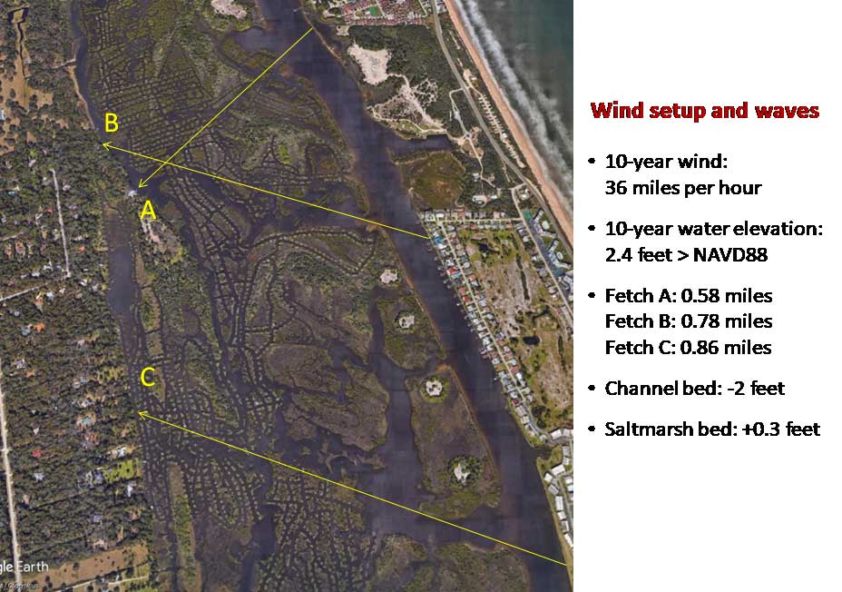 Fig 1. Scenarios for estimating the effect of restoration on setup and waves. |
||||||||||||||||||
| 90 | Water quality, Science | Is there a test on file that shows that this project area has less than 50 lbs. of fish per acre? | No, and the question suggests a miscommunication of the information presented thus far. The take-home message is that an acre of functional salt marsh produces the “food” needed to support 50 lbs. of fish. In short, more productivity supports more fish. In addition, information presented in detail elsewhere clearly demonstrates that restoration has not led to a decrease in the abundance of common and valued fish. It should be clarified that 50lbs/acre of fishes is not a project goal or performance measure but merely an example of a study conducted in the region which we have provided because stakeholders have requested regional studies. |
||||||||||||||||||
| 89 | Water quality, Science | There is a non-dragline area adjoining Sections A & B in this project which has naturally lost wetlands. It was discussed with staff that this occurred naturally due to local environment (ICW, sea level rise, currents, weather events, etc.); and will eventually occur with the restored marsh over time as well. Staff agreed. If this is a possible action that can occur due to the surrounding environment in this location, is the restoration a wise plan financially and regarding the immediate negative effect on the current fish and wildlife? | Yes, it is a good plan because larger pieces of functional wetland last longer. In fact, the sooner the work is completed, the better the chances that the restored area becomes self-sustaining. In addition, we have and can repeat additional steps to protect regions that are affected adversely by disturbances such as boat wakes. |
||||||||||||||||||
| 88 | Water quality, Science | What is the scientific evidence of a collapsed or collapsing ecosystem in the project area? | In short, the degraded area will continue to degrade, with degradation defined as loss of highly productive saltmarsh. The ditching done by draglines between 1960 and 1976 converted approximately 37 acres of saltmarsh to open water, and this degradation has been followed by ongoing loss of approximately 1-2 acres of saltmarsh per year (Figure 1). Since completion of ditching, there has been a loss of over 75 acres of saltmarsh (Figure 2), which translates into hundreds of thousands of dollars of lost services (Costanza, R., et al. 1997. The value of the world’s ecosystem services and natural capital. Nature 387: 253-260). Pushing back against this continued degradation is a key motivation for this project.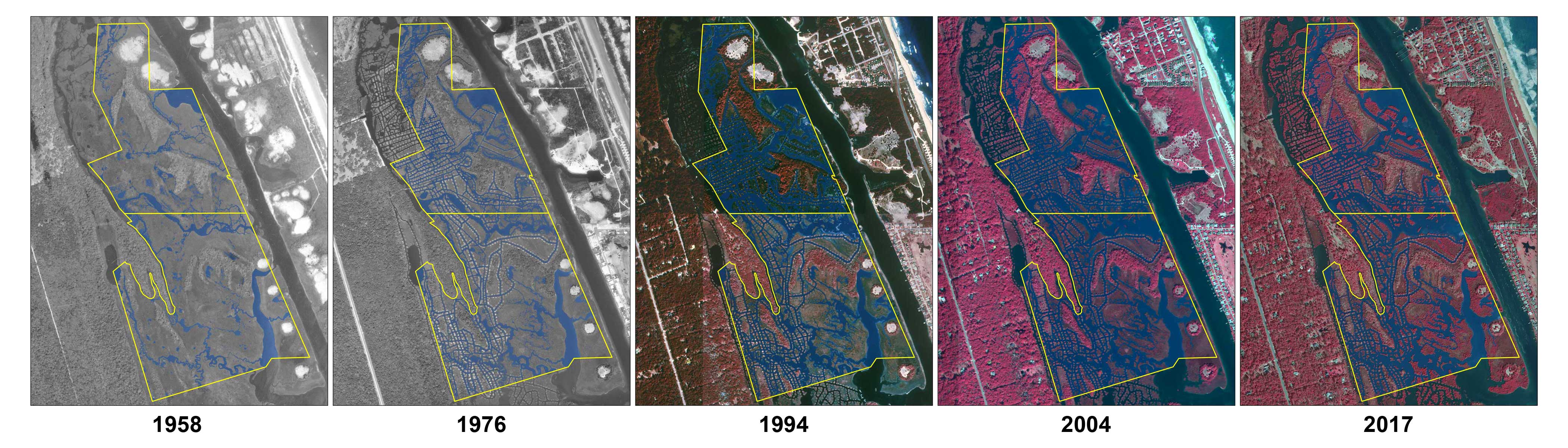 Figure 1. Series of aerial photographs showing changes in saltmarsh and open water. 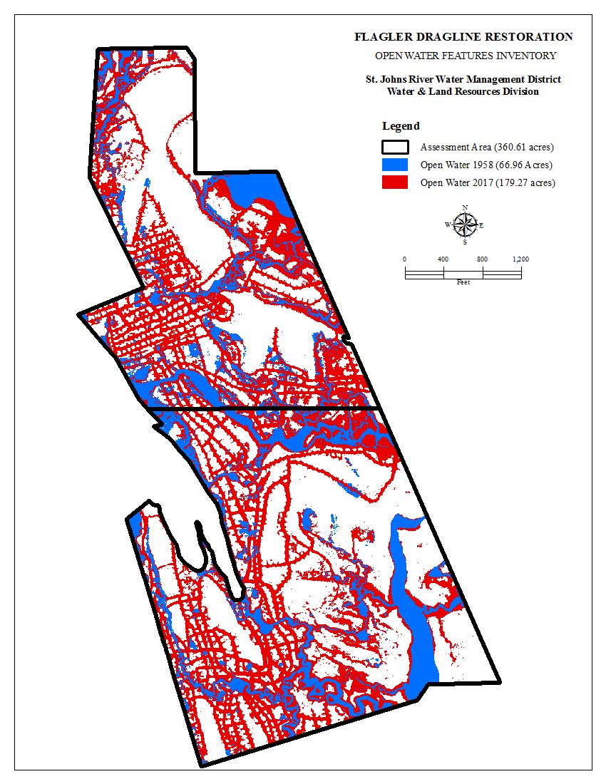 Figure 2. Comparison of open water in 1958 and 2017 |
||||||||||||||||||
| 87 | Water quality, Science | How do you guarantee that water quality in this project will not be adversely affected? | We follow the conditions of our permits, which specifically address turbidity, a key aspect of water quality. In addition, as described above and detailed elsewhere, we are relying on analyses that assessed the effect of restoring one place and over 600 acres in total. Those analyses show water quality was not affected adversely. |
||||||||||||||||||
| 86 | Water quality, Science | Do you have a ‘pre’ and ‘post’ water quality test from a recent project in the Volusia or Flagler area? | ‘Pre’ and ‘Post’ tests at a single place are not the only or necessarily the best way to characterize how restoration of ditched wetland affects water quality. We conducted targeted sampling to demonstrate no detrimental effect on water quality from restoration in Volusia County, and we analyzed broader scale data to demonstrate no detrimental effect from multiple projects completed over a period of years. This information is detailed elsewhere. |
||||||||||||||||||
| 85 | Water quality, Science | Do you have a physical water quality test from this project area that determines it ‘impaired’? | Yes, impairment is determined by the Florida Department of Environmental Protection as detailed elsewhere. The process is applied consistently in waterbodies throughout the state. |
||||||||||||||||||
| 84 | Water quality | In the last workshop it was stated that there is 10% in the budget for monitoring. Will that be used to engage an outside/third party source (third party not currently associated with the project team)? | No. We obtained the grant to fund restoration. Nevertheless, we are working with our partners to develop a viable plan for monitoring key components of the system. |
||||||||||||||||||
| 83 | Water quality | Do you have a core sample to determine if there is DDT in the soil in this project area? | UPDATE: Soil samples were collected Nov. 7, 2018, for organochlorine pesticide analyses (including DDT) from five spoil piles as shown in the map below. DDT was not detected in the samples, and no samples showed levels of pesticides or their components anywhere near the state’s most stringent standards.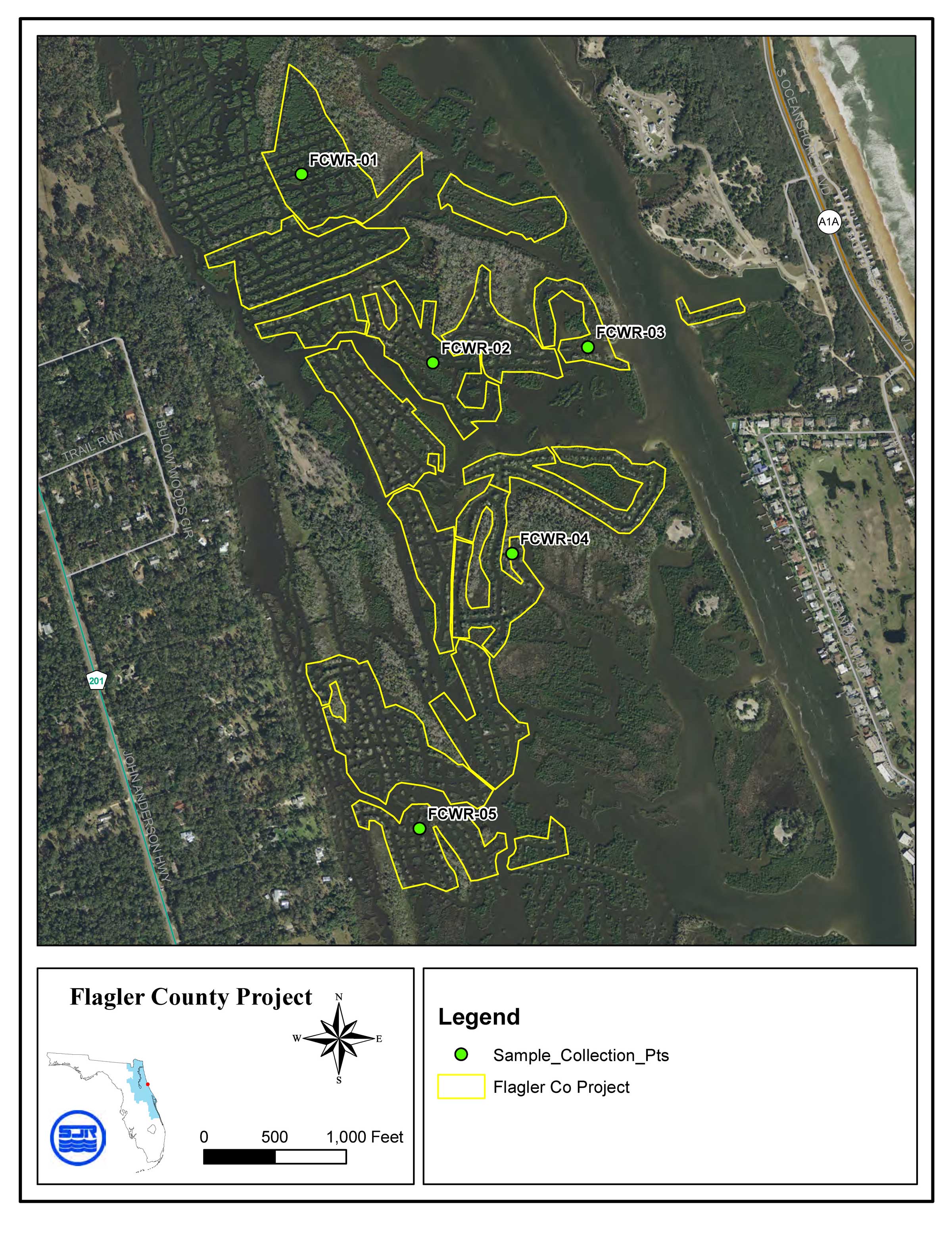 |
||||||||||||||||||
| 82 | Water quality | What will be the impact on bordering property wells with the change in water flow? | There will be no excavation near the upland boundary of the area and no excavation below existing wetland elevation. There will be no direct interaction with groundwater. According to recent literature, ditches increase the likelihood of saltwater intrusion into coastal systems. (Bhattachan, A., et al. 2018. Evaluating the effects of land-use change and future climate change on vulnerability of coastal landscapes to saltwater intrusion. Elementa: Science of the Anthropocene 6:62). |
||||||||||||||||||
| 81 | Water quality | Is our actual water in this 113 acres impaired? Yes or no? | Yes, the Florida Department of Environmental Protection has determined the area to be impaired. | ||||||||||||||||||
| 80 | Water quality | Is our water quality important? Yes or no? | Yes. | ||||||||||||||||||
| 79 | Water quality | Are existing water quality concerns related to Flagler Beach sewer outfall or residential septic tanks? | The likely sources of nutrients that influence concentrations of chlorophyll-a are assessed during the process of developing a total maximum daily load (TMDL) and accompanying basin management action plan (BMAP). Given the results of similar efforts elsewhere, it is likely that existing water quality concerns will be related to sources of nitrogen and phosphorus. Typical sources include discharges of wastewater, leachate from septic systems and discharges of untreated storm water. Restoring wetlands improves water quality but reversing impairment will require additional projects, such as those developed in the BMAP process. The combined effect of the restoration project and BMAP will benefit the estuary by both restoring wetlands that take up nutrients and reducing nutrient loads from multiple sources that contribute to the impairment. | ||||||||||||||||||
| 78 | Science, Water quality | Will the project impact private groundwater wells? | There will be no excavation near the upland boundary of the area and no excavation below existing wetland elevation. There will be no direct interaction with groundwater. According to recent literature, ditches increase the likelihood of saltwater intrusion into coastal systems. (Bhattachan, A., et al. 2018. Evaluating the effects of land-use change and future climate change on vulnerability of coastal landscapes to saltwater intrusion. Elementa: Science of the Anthropocene 6:62) |
||||||||||||||||||
| 77 | Science, Water quality | What long-term monitoring data specific to this area supports water quality claims? | Support for the declaration of impairment come from analyses conducted by the Florida Department of Environmental Protection (DEP) using data from three sites in the relevant waterbody (WBID 2363J, green dots in Figure 1), with samples collected between 2005 and 2017 (13 years). In these samples, annual average concentrations of chlorophyll-a for each of the years exceeded the target concentration (4.5 micrograms per liter).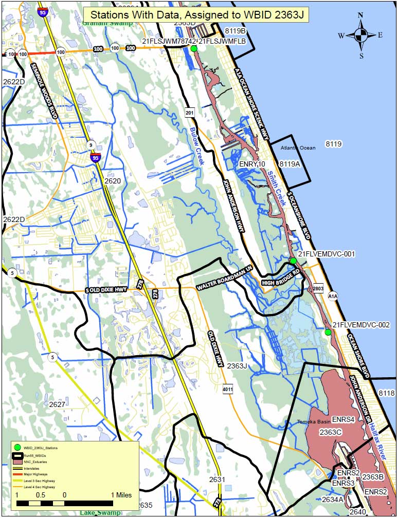 Figure 1. Florida Department of Environmental Protection sampling stations. Although the annual average concentrations of chlorophyll-a appear to be decreasing (Figure 2), a plot of monthly values from the site with the longest period of record (21FLSJWMFLB) shows that the frequency of samples that exceed the target has not decreased (Figure 3). In addition, a plot of the percentage of samples that exceeded the target in each year confirms that approximately 60% of all samples exceed the target throughout the period of record (Figure 4). 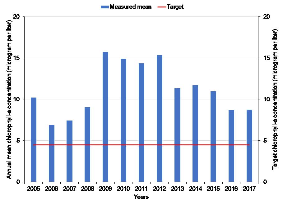 Figure 2. Annual mean concentrations of chlorophyll-a relative to the target. 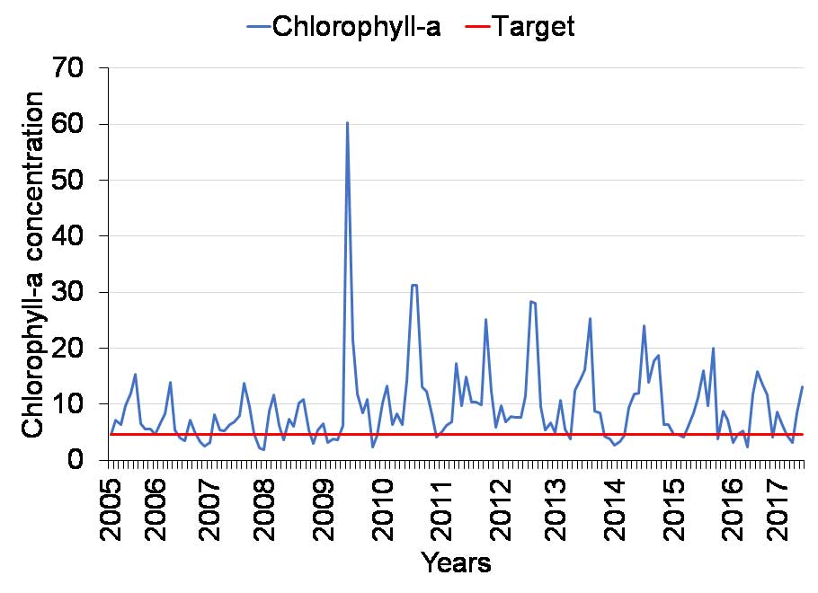 Figure 3. Measured concentrations of chlorophyll-a relative to the target. 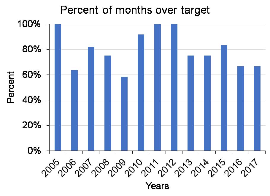 Figure 4. Percent of monthly samples exceeding the target for chlorophyll-a. In addition to evaluating annual mean concentrations, DEP also checks for an increasing trend in chlorophyll-a concentrations using a statistical test. The test did not detect a statistically significant increase. At this time, DEP will focus on other waterbodies, and WBID 2363J will be reevaluated at the end of the next five-year cycle. For those seeking more information about impairments, there are total maximum daily loads (TMDLs) adopted for the waterbody running from SR100 north to the city of Palm Coast (WBID 2363D) and the waterbody running from the southern end of the Tomoka Basin to Daytona Beach (WBID 2363B). These documents can be found at: https://floridadep.gov/dear/water-quality-evaluation-tmdl/content/final-tmdl-reports. |
||||||||||||||||||
| 76 | Science, Water quality | What evidence do you have that there is no DDT in the soil in the project area? | East Flagler County Mosquito Control has no record of DDT being applied in this area since its establishment in 1952. The district committed to testing for DDT by collecting and analyzing soil samples from mounds that will be disturbed. UPDATE: Soil samples were collected Nov. 7, 2018, for organochlorine pesticide analyses (including DDT) from five spoil piles. DDT was not detected in the samples, and no samples showed levels of pesticides or their components near the state’s most stringent standards. SeeFlagler County Soil (DDT) Report of Laboratory Analysis |
||||||||||||||||||
| 75 | Science, Water quality | What scientific data suggests that this area has poor water quality? | The waters were declared impaired by the FDEP in June 2018. The impairment is based on evaluating concentrations of chlorophyll-a, which correlate with the amounts of single-celled algae in the water. According to data collected by the FDEP in the area, average concentrations of chlorophyll-a in the water over the last 13 years exceeded the target concentration by approximately 2-3 times. Algae require nutrients, and the impairment can be attributed to nitrogen and phosphorus from wastewater discharges, stormwater runoff, leachate from septic tanks, and other sources. Eventually, local stakeholders, such as the city of Flagler Beach and Flagler County, will participate in development and adoption of one or more total maximum daily loads (TMDLs), which represent the loads of contaminants that the system can assimilate without showing signs of impairment. A plan to achieve nutrient reductions, termed a Basin Management Action Plan (BMAP), also will be developed and adopted. Restored wetlands will contribute to improved water quality by taking up nutrients that cause the impairment. |
||||||||||||||||||
| 74 | Science, Monitoring | What is the post-project monitoring plan? Please explain water quality, water temperature, fishery, etc. | Before-and-after monitoring is one way to evaluate restoration projects, but the results of such efforts can be confounded by changes at larger spatial scales. For example, the first year after restoration might be a bad year for fish throughout the Halifax River for various reasons unrelated to the project, and a simple before-and-after comparison could lead to the mistaken conclusion that restoration lowered the abundance of fish. Another approach that reduces such confusion is to compare restored sites and nearby undisturbed reference sites, which is the approach that we have taken. Monitoring of fish, oysters, crabs and birds is described below, and in all cases, it indicates that restoring wetlands by grading them to the appropriate elevation yields systems that come to resemble undisturbed areas. A key indicator of success is the plant community because we know that marsh plant species provide energy and habitat for animals. Evidence of successful restoration comes from sampling of plants that characterized over 80 acres of restored wetland. Sampling at three restored sites (Zones 1-3) and one undisturbed site (Zone 4) showed that cover of plants rebounded within approximately 2 years (Figure 1, Donnelly, M., Ph.D. dissertation, 2014, University of Central Florida).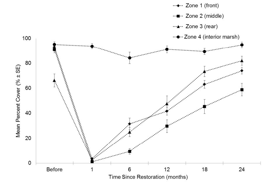 Figure 1. Timeline of recovery of plants at three restored sites (Zones 1-3) and one undisturbed site (Zone 4). The effects of restoration on water quality also have been examined using the reference site approach at two scales: a short-term study focused on an area being restored and a longer term look at data on a regional scale. In both cases, key parameters are turbidity and concentrations of dissolved organic carbon (DOC), dissolved phosphorus (DP), dissolved ammonium combined with dissolved organic nitrogen (termed dissolved Kjeldahl nitrogen, DKN), and chlorophyll-a (an indicator of algal blooms). At Shipyard Island within Canaveral National Seashore in Volusia County, samples to document differences in key parameters were collected before and during restoration at sites that were near and far from the activity (Figure 2). The sites were located within the area delimited by turbidity barriers and at 5 meters (~16 feet), 50 meters (~160 feet), 500 meters (~1,600 feet) and ~3 kilometers (~9,800 feet) outside the area being restored. If restoration caused ecologically important changes, a statistical test should identify a significant interaction between sites and time (before and during restoration). In other words, adverse effects from restoration should be worse during the restoration and near it. Lack of an interaction suggests that differences among sites or times were due to natural variation rather than restoration. Such natural variation is known to occur. 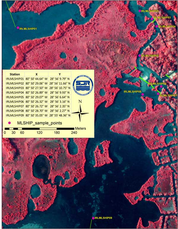 Figure 2. Sampling at a restoration site. red dots = sites for sampling water quality, green lines = turbidity barriers A multivariate, permutation analysis of variance was performed, and the results indicated that sampling was sufficient to detect differences among sites and between times (p 0.05, Table 1). Thus, water quality did vary but not in a manner consistent with an adverse effect from restoration. 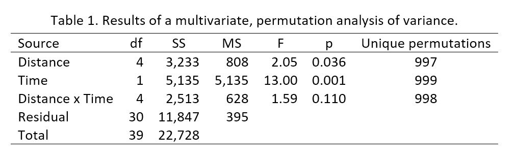 Examination of means for the parameters illustrated the differences among sites that were consistent for both times and the differences between times that were consistent across all sites. Means for all parameters at sites near restoration were not substantially or consistently larger than means for more distant sites (Figure 3), and variation between times was relatively small (Figure 4). Mean turbidity remained below 15 nephelometric turbidity units (ntu), so it was well within the limit set by the permit (29 ntu above background, with 29 ntu above zero shown in Figures 3 and 4). 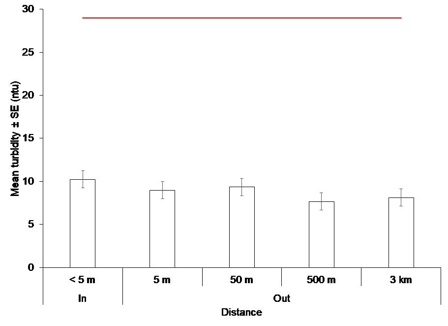 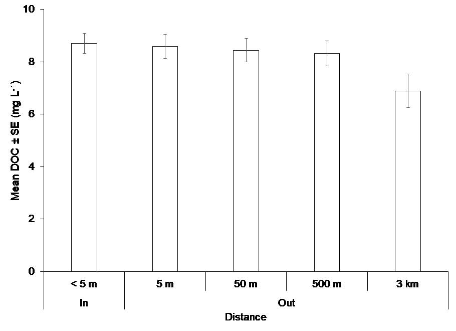 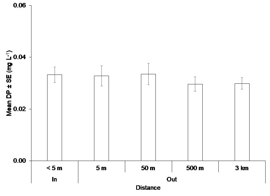  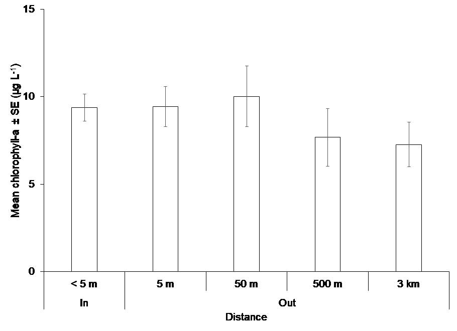 Figure 3. Mean values for water quality parameters ± standard errors (SE) at five sites. DOC = dissolved organic carbon, DP = dissolved phosphorus, DKN = dissolved Kjeldahl nitrogen (ammonium and organic nitrogen), ntu = nephelometric turbidity unit, mg = milligram, L = liter, μg = microgram, km = kilometer 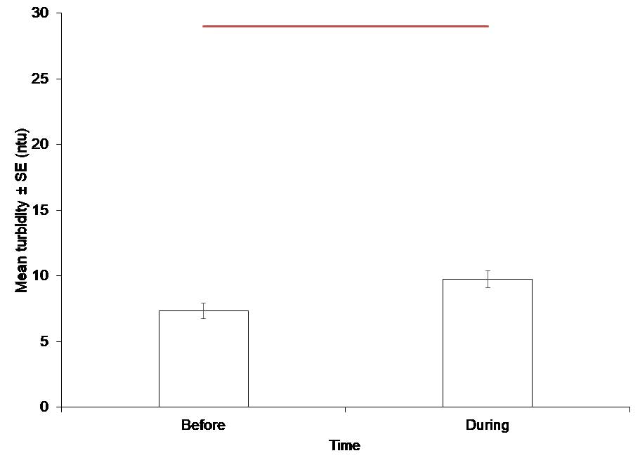 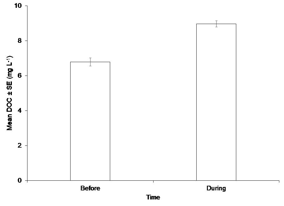 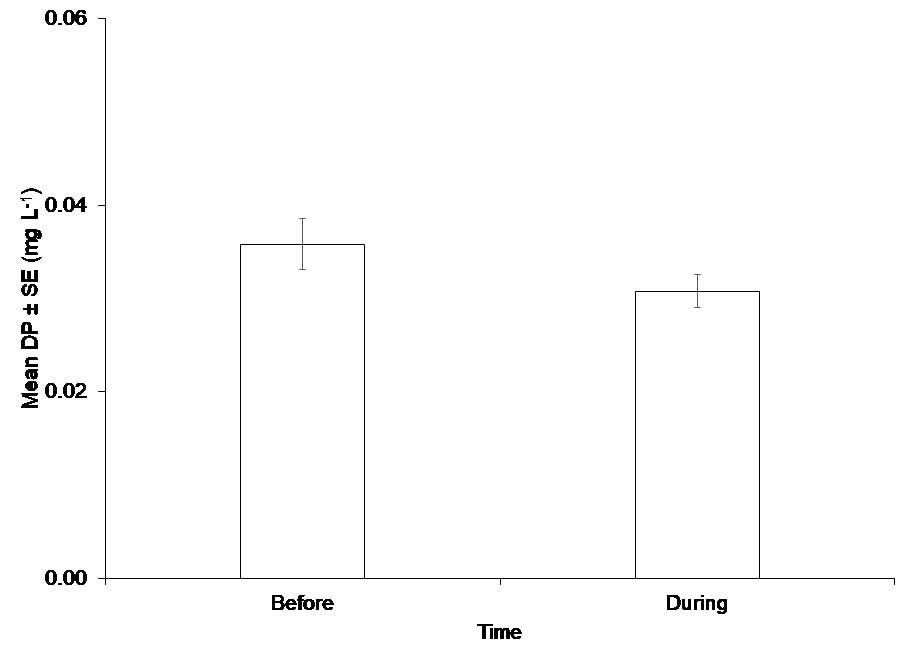 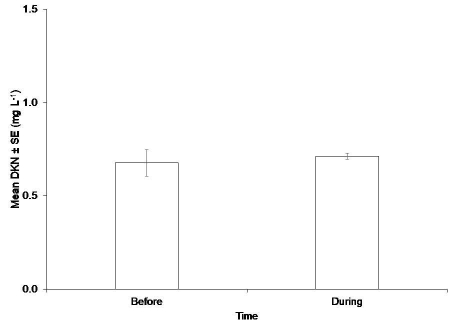 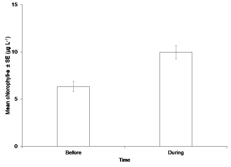 Figure 4. Mean values for water quality parameters ± standard errors (SE) at two times. DOC = dissolved organic carbon, DP = dissolved phosphorus, DKN = dissolved Kjeldahl nitrogen (ammonium and organic nitrogen), ntu = nephelometric turbidity unit, mg = milligram, L = liter, μg = microgram Data from monthly sampling provides a look at a longer timeframe and the regional scale. Sites labelled IRLV11 and IRLV17 were closest to the restoration done in Mosquito Lagoon during the summer of 2014, sites IRLV05 and IRLML02 bracket those sites, and sites IRLI02 and IRLI07 were near Haulover Canal that connects Mosquito Lagoon to the Indian River Lagoon (Figure 5). 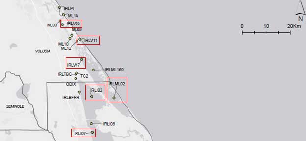 Figure 5. Locations where samples were taken marked by red boxes. Across nine years at this spatial scale, there is no evidence that restoration in 2014 had detrimental effect on water quality. Again, functional wetlands promote improved water quality, but functional wetlands cannot overcome excessive loads of nutrients. In the waters near these sites, excessive nutrient loads are being addressed by an adopted basin management action plan for the northern Indian River Lagoon (BMAP, fhttps://floridadep.gov/sites/default/files/north-IRL-bmap.pdf) and a reasonable assurance plan that is in development for Mosquito Lagoon (RAP, see background information at: https://floridadep.gov/dear/watershed-assessment-section/content/4b-assessments-raps). More insights can be gained by looking at graphs of mean values through time, with a focus on 2014, which is when restoration was done (Figure 6). Mean turbidity varied, with relatively low values everywhere in summer 2014, and all values were below 15 ntu so the conditions of the permit were met. Concentrations of DOC, DP, and DKN also varied, but means at the sites nearest the restoration were lower than or essentially equal to values from further south. Higher chlorophyll-a concentrations, which are a key indicator of eutrophication, tended to occur at all six sites at about the same times. Also, note that the sites nearest the restoration (IRLV11 and IRLV17) tended to have lower concentrations than sites further south. One exception was an intense brown tide that caused chlorophyll-a concentrations greater than 50 micrograms per liter at multiple sites in 2012–2013. The project partners are currently designing additional monitoring plans for water quality, plants and animals associated with the project to study the effects of restoration in greater detail, and the funding for this effort is pending approval. 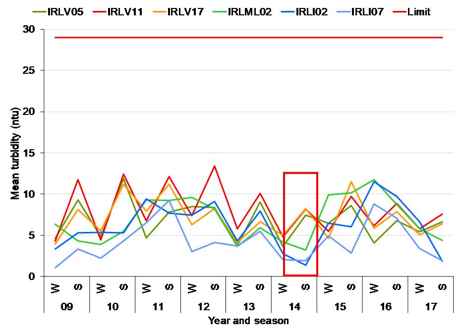 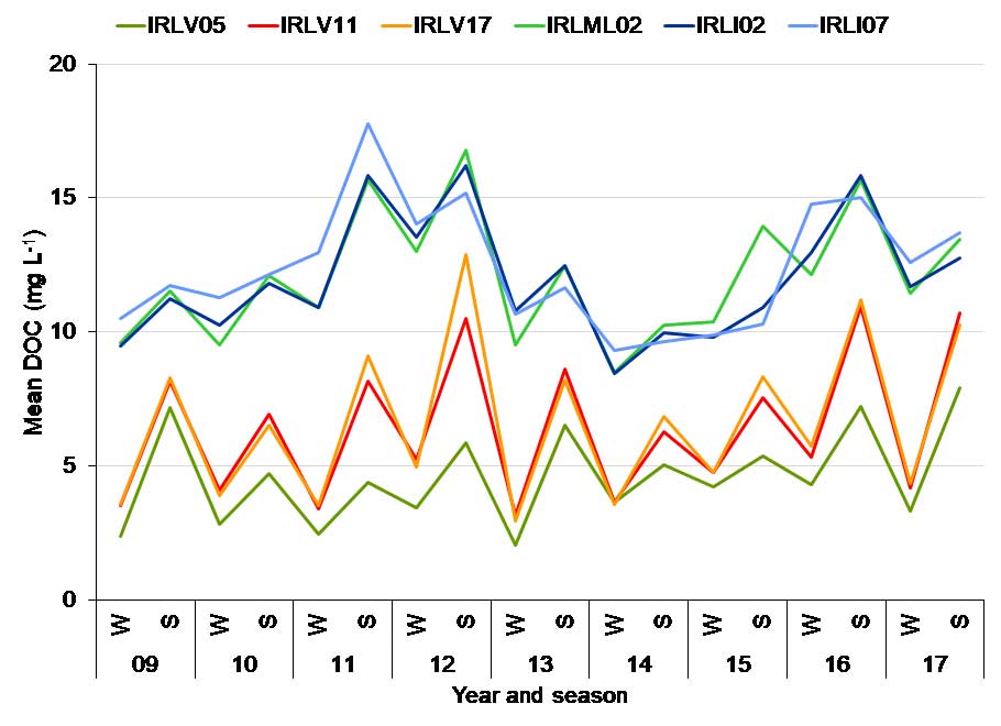 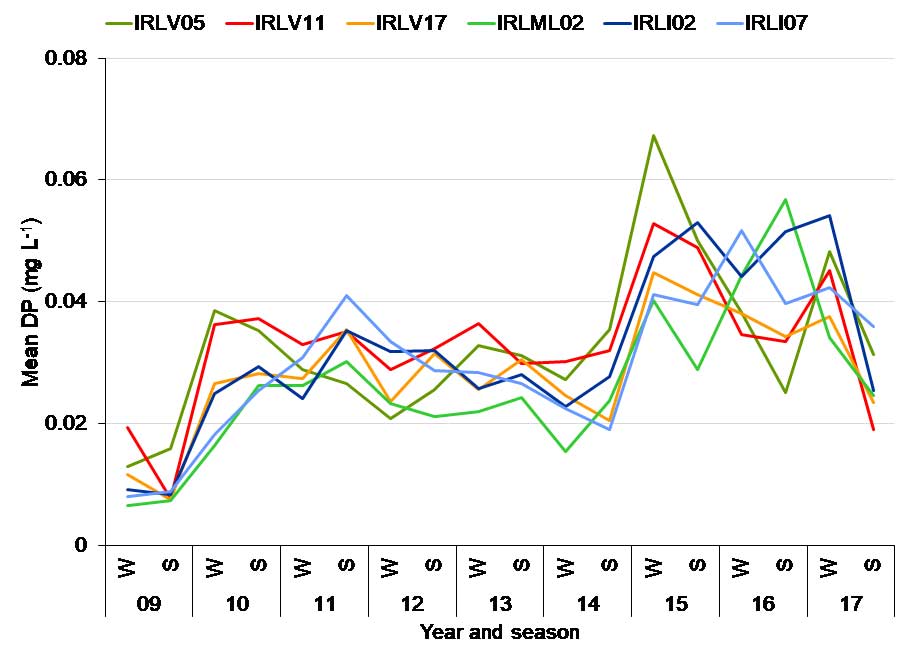 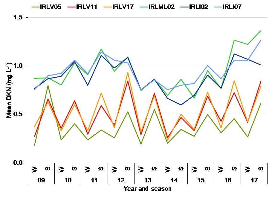 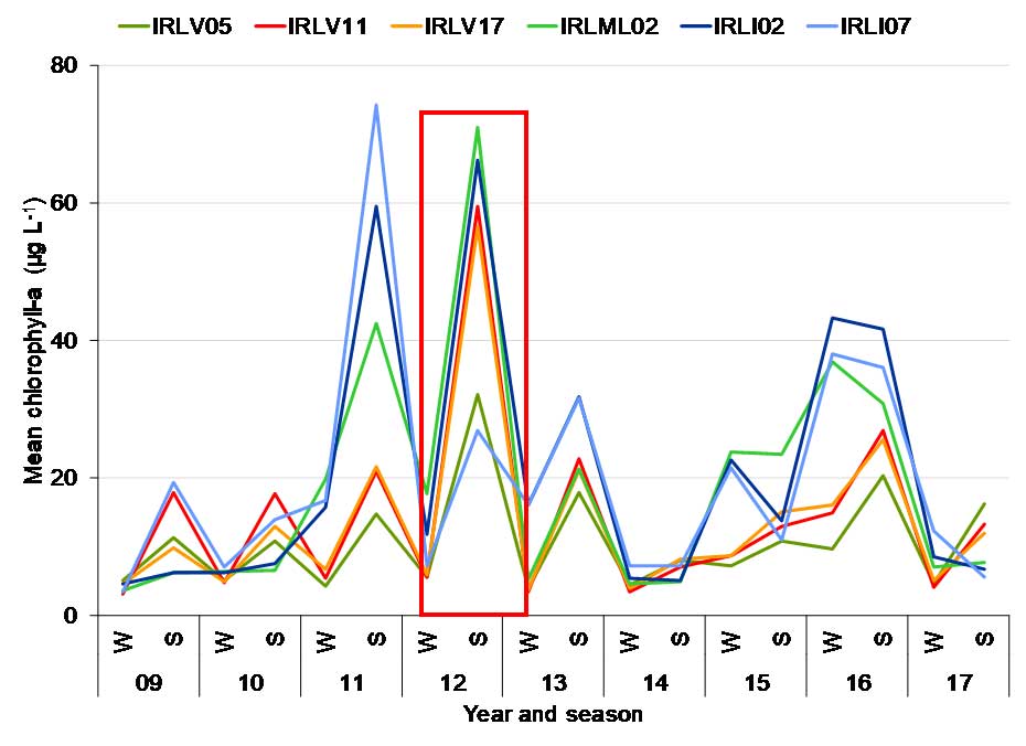 Figure 6. Mean values for water quality parameters, with patterns highlighted by red boxes. DOC = dissolved organic carbon, DP = dissolved phosphorus, DKN = dissolved Kjeldahl nitrogen (ammonium and organic nitrogen), ntu = nephelometric turbidity unit, mg = milligram, L = liter, μg = microgram, W = winter, S = summer |
||||||||||||||||||
| 73 | Science, Do nothing option | What happens if nothing is done? | In short, the degraded area will continue to degrade, with degradation defined as loss of highly productive saltmarsh. The ditching done by draglines between 1960 and 1976 converted approximately 37 acres of saltmarsh to open water, and this degradation has been followed by ongoing loss of approximately 1-2 acres of saltmarsh per year (Figure 1). Since completion of ditching, there has been a loss of over 75 acres of saltmarsh (Figure 2), which translates into hundreds of thousands of dollars of lost services (Barbier, E., et al. 2011. The value of estuarine and ecosystem services). Pushing back against this continued degradation is a key motivation for this project. We do not know precisely how the spoil piles will be affected by sea level rise, but several studies have shown that saltmarshes and mangroves are capable of keeping up with current rates of sea level rise due to peat formation through plant production and sediment trapping, especially where marsh elevation is low and inundation of water high (Kirwan, M, et al. 2010. Limits on the adaptability of coastal marshes to sea level rise. Geophysical Research Letters 37: L23401). As evidence, sediment cores show that these habitats have occurred in some places for thousands of years. By restoring part of the marsh to appropriate elevation, there is a greater likelihood of a significant amount of marsh remaining over time. Also, the spoil piles are primarily sand, and research shows that mangroves occurring in primarily sandy soils, as opposed to silty ones, experience greater fluctuations in salinity and therefore greater stress and decreased productivity (Chapman, P, 1981. Measurements of short-term stability of interstitial salinities in subtidal estuarine sediments. Estuarine and Coastal Shelf Science 12:67-81). Figure 1. Series of aerial photographs showing changes in saltmarsh and open water. Figure 2. Comparison of open water in 1958 and 2017. |
||||||||||||||||||
| 72 | Science | The current ditch depths act as a rudimentary radiator providing a means to cool water temperatures in the shallow basins on hot summer days. What effect will the project have on the water temperatures; specifically, will it raise the water temperatures? | Temperatures in the open water areas are controlled primarily by tidal exchange, which will not be altered. In addition, the marsh is to be graded uniformly, which minimizes or eliminate shallow pools of water. |
||||||||||||||||||
| 71 | Science | Unlike the restoration project recently completed near the Knox Bridge (High Bridge) area, the project in question largely involves an area of the marsh that is a considerably greater distance from the Intra-Coastal waterway. Most of the natural portions of marsh that exist, like the basin directly behind my house, have a shallow depth at mean tide. I would guess the average depth to be around 1-2 feet. The man-made canals dug for mosquito control have actually created and provided a very important, but largely unknown benefit to the marsh. These canals provide a higher flow rate of water for ingress and egress to the more remote parts of the marsh. In addition to providing the marsh with a more direct avenue for flow, this in turn acts as a rudimentary radiator, providing a means to cool water temperatures in the shallow basins on hot summer days. During the hottest months of the year most aquatic life cannot sustain themselves in these parts of the marsh during peak daylight times. The water is simply too hot. Most of the inhabitants in these effected areas will either move out into the ICW or take refuge in the depths of the man-made canals during the day. The canals are generally deep enough that sunlight is filtered from tannins in the water, and providing a greater volume of flow, this in turn considerably lowers temperatures by as much as 10-15 F when compared to the shallow basins. This delicate equilibrium is an incredibly nuanced balance. As marsh water depths are reduced, even if more surface area is created by the removal of tussets and spoil piles, water temperatures will be increased. Any statement to the contrary by representatives of the SJRWMD (St. Johns Water Management District) are simply false. | Temperatures in the open water areas are controlled primarily by tidal exchange, which will not be altered. In addition, the marsh is to be graded uniformly, which minimizes or eliminate shallow pools of water. | ||||||||||||||||||
| 70 | Science | What is the science, how does it work, and does it work? Are there examples of similar successful projects? | The district has been implementing this restoration method for 18 years and has restored more than 600 acres, which returned about 250 acres to wetland elevation. Once the elevation is right, revegetation occurs through natural recruitment. A description of past work can be found in Rey et al. 2012 published in Wetland Ecology and Management, volume 20, pages 197-211. Recovery of vegetation in similar projects in the Indian River Lagoon is depicted in the graph below (Donnelly 2014 PhD Dissertation, University of Central Florida). |
||||||||||||||||||
| 69 | Overview, Other | Is any portion of the project on land owned by private individuals? | The entire project will occur on state-owned lands including a portion of Gamble Rogers Memorial State Recreation Area and areas adjacent to the Tomoka Marshes Aquatic Preserve. The plan has been developed in consultation with DEP Aquatic Preserve and State Park staff. | ||||||||||||||||||
| 68 | Overview, History | When was this project started? | All disturbed wetlands between Jacksonville and Ponce de Leon Inlet were mapped prior to 2007, and staff used these maps to identify a suitable publicly-owned site to support our request for an extension of a federal grant in mid 2017. The extension was required because the equipment being used became unavailable. The site in southern Flagler County was identified as a possible candidate, and SJRWMD received support for the concept from FDEP State Park and Aquatic Preserve staff in 2017. The extension of funding was granted in November 2017. Next, we needed a practical, cost-effective source for the appropriate equipment. The ensuing search extended through the spring of 2018, and it resulted in an Invitation for Bid (IFB) being issued by SJRWMD in mid June. At the same time, we pursued confirmation that the lands belong to the State and that it was appropriate for the project to restore the wetlands from the FDEP. SJRWMD applied to FDEP and the U.S. Army Corps of Engineers (USACE) for permits to restore 113 acres on July 11, 2018. SJRWMD received the FDEP permit on Aug. 7, 2018. Bids for the equipment contract were opened on the same day. SJRWMD obtained the USACE permit on Aug. 23, 2018. However, the project will not move forward until approved by the Governing Board on Sept. 11, 2018, and all supporting financial agreements and contracts are signed. The earliest work could start is mid September 2018. | ||||||||||||||||||
| 67 | Overview, History | How was the site selected? | The site in southern Flagler County was identified as a candidate for restoration because it met key criteria. It was degraded by ditching in the 1950s, 1960s and 1970s, it is degrading further as the remaining patches of wetland convert to less productive open water, it is entirely on state-owned land, and it is just north of an area where previous restoration was successful. | ||||||||||||||||||
| 66 | Overview, Funding | How is this restoration being funded? | The $541,000 project is funded by the partners, including monetary and in-kind support from FWC, SJRWMD and FDEP to provide match for a $316,000 federal grant to FWC from the National Coastal Wetlands Conservation Grant Program, administered by the USFWS. This grant program is funded by federal excise taxes on fishing equipment and fuel for motorboats and small engines.
|
||||||||||||||||||
| 65 | Overview, Benefits | What are the primary benefits of restoration? | When coastal marshes are restored, there is more space for wading and shore birds and greater production of the plants that provide food for shrimp, crabs and fish. Other benefits include filtering and cleaning of water, more native wetland plants, such as black mangroves, and less undesirable invasive vegetation, such as Brazilian peppers. | ||||||||||||||||||
| 64 | Overview | How much of the marsh system is being restored? | The district has successfully restored more than 600 acres of dragline ditch-impacted wetlands in Volusia County, including Tomoka, Bulow and North Peninsula state parks and the Mosquito Lagoon. The new project in southern Flagler County has a footprint of just over 113 acres. About 40 additional acres are expected to be returned to functional wetland that will provide multiple benefits. | ||||||||||||||||||
| 63 | Other, Fish | Some fishing guides were unable to attend the recent workshop. Will the partners meet with them to gather information about important fishing spots? | On Oct. 17, 2018, the Florida Fish and Wildlife Conservation Commission (FWC) coordinated a meeting between local fishing guides and the partners. The guides provided input on the footprint of the project and comments about there being lots of fish near sites of previous projects in Volusia County. They also stated that they were glad to hear that the focus is to restore marsh habitat because of its importance for fisheries production. They also noted that open water adjacent to natural (non-spoiled) marshes in the region provides some of the best fishing opportunities. | ||||||||||||||||||
| 62 | Other | The Oct. 4 workshop meeting space was too small for the crowd, and the acoustics and format made it difficult to hear. Will the next meeting be located to a more audience-friendly venue? | Yes. The new venue for the Nov. 7, 2018, meeting is Santa Maria del Mar Catholic Church (Sanctuary), 915 N. Central Ave., Flagler Beach, FL 32136. The meeting starts at 5:30 p.m. | ||||||||||||||||||
| 61 | Other | Why have we not been included in the process until now or after residents discovered what was happening to the property? | There was extremely limited certainty regarding the viability and size of the project until bids were processed in August 2018. With greater certainty and significantly more information, the project partners are now able to communicate details about the project and the process to homeowners adjacent to the public lands on which the project is anticipated to occur. | ||||||||||||||||||
| 60 | Navigation, Other | When working with residents to identify important navigable passages, will alternatives based on variable water levels be guaranteed? | No, we have sought and considered input regarding access from the public. The goal will be to ensure navigable passages even during low water. |
||||||||||||||||||
| 59 | Navigation, Other | How will the project impede navigable waterways and access? Will this project interfere with riparian rights? | No. |
||||||||||||||||||
| 58 | Mosquito control | Will the increase in mosquito breeding ground cause an increase in chemical spraying? | According to the East Flagler Mosquito Control District, the abundance of mosquitos is not expected to increase so there would be no need for additional spraying. This conclusion is based on records from Volusia County where previous restoration was completed. |
||||||||||||||||||
| 57 | Mosquito control | What increase in mosquito infestation will approximately 40 acres of salt water marsh produce? | None. With careful grading, neither the restored wetland or the remaining unfilled ditch have caused additional production of mosquitos following previous projects. |
||||||||||||||||||
| 56 | Mosquito control | This August, Volusia County reported the first human Eastern Equine Encephalitis (EEE) case in 15 years. There are additional reports in animals. EEE is considered more serious than West Nile. Salt marsh mosquitoes are considered prime vectors for Eastern Equine Encephalitis, Venezuelan equine encephalitis and dog heartworm. | To clarify our earlier response, the virus that causes Eastern Equine Encephalitis (EEE) can live in saltmarsh mosquitoes (Aedes taeniorhynchus and Ae. sollicitans), but these species have not been shown to be a primary vector for EEE in nature. EEE is most often associated with freshwater mosquitoes in freshwater swamps. Ae. taeniorhynchus and Psorophora columbiae were implicated in an outbreak of Venezuelan Equine Encephalitis in South America (Columbia) in 1995. In addition, saltmarsh mosquitoes, along with many other common species in Florida, are potential vectors of dog heartworm. In any case, experience with previous restoration projects has shown that restoration does not increase populations of saltmarsh mosquitoes. |
||||||||||||||||||
| 55 | Mangroves, Habitat, Revegetation | Will protected black mangroves be damaged by the project? | Small areas of mangroves will be disturbed by this project. The permit addresses the height and diameter of mangroves that can be removed. The mangroves growing on the side of any spoil pile nearest a ditch to be filled will be buried in the ditch and covered with spoil to wetland elevation. These restored areas will become part of a larger and more robust stretch of wetland vegetation, including areas that mangroves can recolonize. Thus, unlike losses due to construction of seawalls and docks, the impact is temporary, and the result is more functional wetland. Again, intact wetlands will not be impacted. | ||||||||||||||||||
| 54 | Mangroves | Can the mangroves grow back with severe stress? If so, what is the timeline? | Yes, mangroves return after stress, with returns after cold snaps being an example. Timelines for recolonization vary, but mangroves are usually one of the first plants to come back. |
||||||||||||||||||
| 53 | Mangroves | How do mangroves perform to stabilize erosion and mitigate sea level rise vs. salt marsh? | Both salt marshes and mangroves stabilize shorelines and protect inland ecosystems and human development from wave energy, storm surge, and erosion (Barbier, E.B., et al. 2011. Ecological Monographs 81: 169-193; Kathiresan, K. 2012. International Journal of Marine Science 2: 70-89; McIvor, A.L., et al. 2012. Storm surge reduction by mangroves. Natural coastal protection series: Report 2. Cambridge coastal research unit working paper 41). Salt marshes dominate the coast in northern Florida where temperatures occasionally dip below freezing, while mangroves are predominant in the warmer, southern regions. Thus, salt marsh is an extremely valuable habitat Flagler and St. Johns counties, where the likelihood of mortality during winter is high for mangroves. Although the shorelines of salt marshes can be eroded by large storms, the eroded sediment often returns during calmer intervals (Pethick, J.S. 1992. Saltmarsh geomorphology. pp. 41-62 in Allen J.R.L. and Pye K. (eds). Saltmarshes: morpho dynamics, conservation and engineering significance; Boorman, L.A. 1999. Mangroves and salt marshes 3: 227-241). This dynamic capacity to erode and redeposit sediment can make salt marshes more valuable than sea walls for protecting inland property, with larger marshes being more resilient buffers (King, S.E. and Lester, J.N. 1995. Marine Pollution Bulletin 30: 180-189; Boorman, L.A. 1999. Mangroves and salt marshes 3: 227-241). Both mangroves and salt marsh can cope with some amount of sea-level rise by accumulating sediment, and both habitats can migrate landward if refugia, in the form of undeveloped and conserved lands, are present. Thus, both habitats provide value, with a shift to only one type of habitat leading to some winners and some losers among fish and wildlife. One rationale for this project is to push back against the ongoing loss of salt marsh to maintain valuable diversity. |
||||||||||||||||||
| 52 | Mangroves | When can a map of mangroves to be removed be available? | Due to the construction technique, we are not producing a map. |
||||||||||||||||||
| 51 | Mangroves | How many will be removed? | As few as possible. Our permit authorizes clearing of vegetation and grading of spoil that are above the targeted elevation. Some mangroves located between the spoil and the ditch to be filled will be impacted by restoration. Spoil will be graded in a manner that impacts as few mangroves as possible. Larger mangroves will be given preference for preservation. The small areas of mangroves impacted by the work will become part of larger and more robust areas that are appropriate for multiple types of wetland vegetation, including recolonization by mangroves. |
||||||||||||||||||
| 50 | Mangroves | How many mangroves are currently present? | We do not know. |
||||||||||||||||||
| 49 | Mangroves | I would like to point out that any such endeavor to restore this marsh will be an exercise in futility. As a boy, I observed very few mangrove trees north of Volusia county, And even fewer Snook. Due to the climate changes we are experiencing, I have seen the mangroves completely envelope regions of the marsh on the east side of the Intra-Coastal from 23rd street south all the way to the south side of the Flagler Beach Bridge. These marshes were entirely marsh grass just 20 years ago and today there is very little grass left. The mangroves have grown so tall and thick they have drowned all life beneath them. This process is well underway in the area under restoration consideration and given a few more years the mangroves will have had their way, undoing any and all attempts by man to alter the natural habitat for filtering vegetation such as marsh grasses. | It is true that mangroves are colonizing areas further north than in the past. However, mangroves remain subject to mortality during cold snaps, so their distribution may change relatively rapidly. Salt marsh is more able to withstand cold weather, so its distribution is less likely to change. In addition, considerable salt marsh remains in northern Volusia and Flagler counties despite colonization by mangroves (see p. 147 in Chapter 13 in Radabaugh, Kara R., Christina E. Powell, and Ryan P. Moyer (eds.). 2017. Coastal Habitat Integrated Mapping and Monitoring Program Report for the State of Florida. Florida Fish and Wildlife Conservation Commission, Fish and Wildlife Research Institute Technical Report No. 21, http://myfwc.com/media/4242350/chimmp2017-chapter13-northeast-fl.pdf). The wetlands in Flagler County are changing over time into ‘mangrove-marsh’ communities due to climate change, becoming more similar in some ways to the productive wetlands to the south in the Indian River Lagoon (Seaman, W., ed., 1985. Florida aquatic habitat and fishery resources. Florida Chapter of American Fisheries Society). Mangroves provide many of the same ecosystem services as saltmarsh including primary production and providing habitat for crabs, fish, and shrimp (Odum, W., et al. 1982. The ecology of mangroves of south Florida. U.S. Fish and Wildlife Service FES/OBS 81-24). |
||||||||||||||||||
| 48 | Flooding | Looking at the actual statement provided by SJRWMD on the project website whereby it is mentioned as a possible positive side effect, that this project will serve to “moderate storm/ flood damage to upland areas by slowing advancing water.” I would like to point out that this statement is highly inaccurate, and laughable, in that when this area now and later, is impacted by storm surges as the result of nor’easters or tropical cyclones, the storm surge doesn’t care how much marsh grass there is. When the water gets high enough it will go wherever physics says it can go and as fast as the wind can push it. No amount of manmade interference can slow or stop that short of building a lock across every inlet on the east coast. One has to consider the requirements of the SJRWMD on all developable property that retention/detention areas are intended to have a “depth” and volume to hold storm waters. While that premise is for exchanging impervious service displacement the affect is similar here. As you take away volume in depth, you spread the water wider – hence higher. | We examined the potential effect of restoring degraded wetlands on water levels and waves generated by wind. Unlike using fill to raise the elevation of a house or creating new impervious surface, the project is not adding soil to the area or altering the ability of the area to hold water, so restoration will not force water to flow to another site. Extreme events, such as hurricanes, create storm surge, with water from the ocean forced through inlets toward the land. Data from the Federal Emergency Management Agency indicate that surges caused by Category 3 or stronger hurricanes will flood the region regardless of whether the restoration is completed. Analysis of historical data and targeted modeling indicated that high water in the area (setup) is primarily due to water being pushed through the inlets during periods of strong easterly winds (Figure 1). Due to the limited fetch (the distance traveled by wind or waves across open water), winds cannot generate substantial local setup or waves as high as a foot even after the area is restored. This modeling applied standard methods used by the U.S. Army Corps of Engineers, and it was based on rather severe and unusual conditions, with 2.4 feet of water above the datum and a 36 mile per hour wind. Both events are predicted to occur only once every 10 years, and the setup is almost equal to the 2.5 feet predicted for category 2 hurricanes. Furthermore, the modeling did not consider the dampening effects of shallow areas in open water, such as shoals or oyster reefs, or vegetation recolonizing restored surfaces. Vegetation will recruit to the restored area, and smooth cordgrass Additional modeling showed that a few piles of spoil along the line of fetch will reduce the waves by 50-60%. This reduction is expected to occur because some piles of spoil will not be touched during the project. For restored areas which will recruit native plants such as wetland grasses and mangroves, research using a wave pool has shown that one-year old smooth cordgrass planted at a density of 37 shoots per 0.25m2 can reduce wave energy by ~32% (Manis, J., 2013. Assessing the effectiveness of living shoreline restoration and quantifying wave attenuation in Mosquito Lagoon, Florida. University of Central Florida M.S. Thesis). Fig 1. Scenarios for estimating the effect of restoration on setup and waves. |
||||||||||||||||||
| 47 | Flooding | Will homes in the project area experience a rise in surface water levels during storm events, king tides, etc.? Will the project change the way water flows onto neighboring private properties? | SJRWMD examined the potential effect of restoring degraded wetlands on water levels and waves generated by wind. Unlike using fill to raise the elevation of a house, the project is not adding soil to the area, so it will not force water to flow to another site. Extreme events, such as hurricanes, create storm surge, with water from the ocean forced through inlets toward the land. Data from the Federal Emergency Management Agency indicate that surges caused by Category 3 or stronger hurricanes will flood the region regardless of whether the restoration is completed. Analysis of historical data and targeted modeling indicated that high water in the area (setup) is primarily due to water being pushed through the inlets during periods of strong easterly winds (Figure 1). Due to the limited fetch (the distance traveled by wind or waves across open water), winds cannot generate substantial local setup or waves as high as a foot even after the area is restored. This modeling was based on rather severe and unusual conditions, with 2.4 feet of water above the datum and a 36 mile per hour wind. Both events are predicted to occur only once every 10 years, and the setup is almost equal to the 2.5 feet predicted for category 2 hurricanes. Furthermore, the modeling did not consider the dampening effects of shallow areas in open water, such as shoals or oyster reefs, or vegetation recolonizing restored surfaces. Additional modeling showed that a few piles of spoil along the line of fetch will reduce the waves by 50-60%. This reduction is expected to occur because some piles of spoil will not be touched during the project. For restored areas which will recruit native plants such as wetland grasses and mangroves, research using a wave pool has shown that one-year old smooth cordgrass planted at a density of 37 shoots per 0.25m2 can reduce wave energy by ~32% (Manis, J., 2013. Assessing the effectiveness of living shoreline restoration and quantifying wave attenuation in Mosquito Lagoon, Florida. University of Central Florida M.S. Thesis). Figure 1. Scenarios for estimating the effect of restoration on setup and waves. |
||||||||||||||||||
| 46 | Flooding | After the project is completed, will flooding of the area increase? | The restored wetland surface will be inundated by natural tides more frequently than the current spoil areas, but upland flooding is not expected to change as a result of the project. In fact, wetlands provide protection against waves generated by storms because they cause the wave energy to dissipate slowly rather than rebound off a hard surface, and the ability of wetlands to maintain their viability by accumulating sediment means that they are one of the best habitats for providing ongoing benefits in the face of rising sea levels. | ||||||||||||||||||
| 45 | Fish, Wildlife, Habitat | Perhaps one of the more finicky inhabitants on the marsh is the Fiddler crab, an important food source for fish and birds. Fiddler crabs need exposed banks of just the right mixture of shell and sand to flourish, not partially submerged wetland with boiling water. The Fiddler crab habitat will be totally gone. | Surveys of fiddler crabs in approximately 80 acres that were restored to wetland elevation (Zones 1, 2 and 3, Figure 2, Donnelly, M., Ph.D. dissertation, 2014, University of Central Florida) showed that their numbers remained similar to those in undisturbed areas (Zone 4, Figure 2) throughout restoration. Numbers on the highest ground (Zone 2 on the top of spoil) increased from zero before restoration to 3–4 crabs per square meter after 24 months because grading the area to the elevation of the surrounding wetland provided a better habitat for crabs (Figure 2).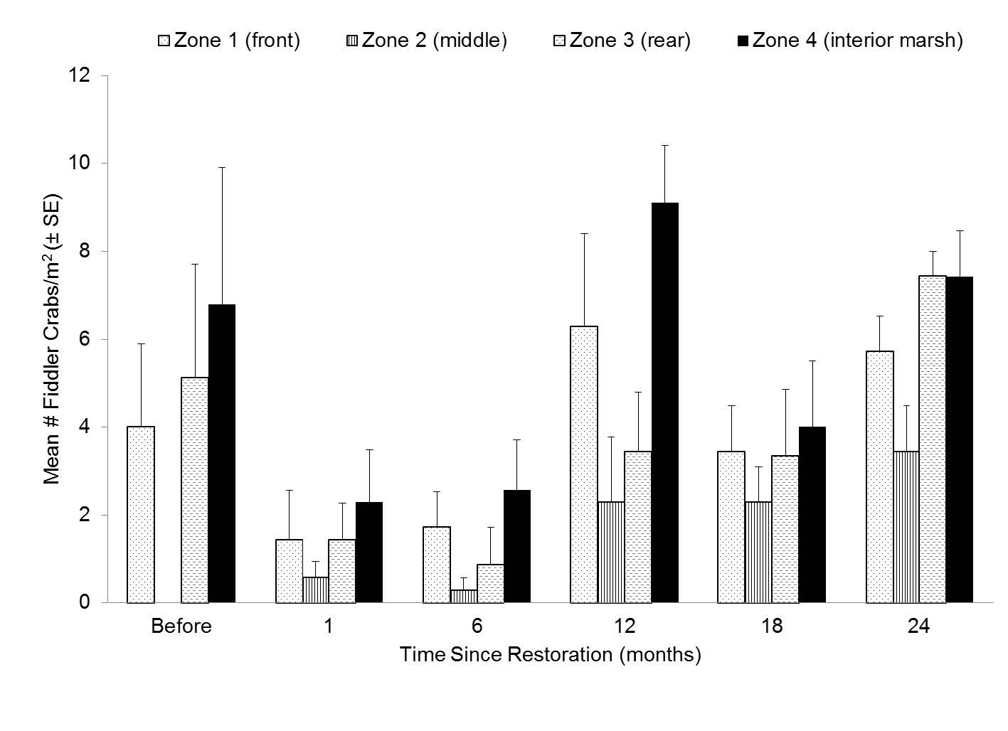 Figure 2. Mean numbers of fiddler crabs per square meter (m2, approximately 11 square feet). |
||||||||||||||||||
| 44 | Fish, Wildlife, Habitat | The oyster is one of the most sensitive, vulnerable and yet important organisms that will be impacted by this project. Oysters cannot survive abrupt changes to the environment that they have established themselves in. They require a specific water quality and food source. Unlike all other creatures they cannot leave when their habitat is compromised. Most of the oyster bars in this area are alive and healthy. This can be verified in the SJRWMD survey. Only a few small areas have died. As water temperatures are made to increase and overall volumes of flow are reduced by this project, I fear many of these oyster beds will not survive. The oyster beds provide one of the most important habitats in the marsh. At night the oyster bars become an amazing hotbed of activity and life for predators and prey alike. Many species heavily rely on these beds for survival. | Oysters have not been affected negatively by past restoration projects. Therefore, we do not anticipate that they will be affected negatively by the proposed project. During the summers of 2017 and 2018, 46 randomly selected, oyster reefs in Mosquito Lagoon were surveyed by researchers from the University of Central Florida. During surveys, two methods were used to count live oysters, with each method repeated 4–5 times on each reef. Counts of live oysters generated by both methods were analyzed for significant differences among distances from a restored wetland. The results indicated that the number of live oysters differed significantly among the three distances (p 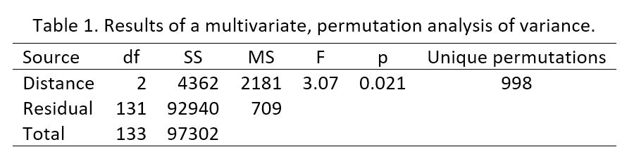 Examination of the mean numbers of live oysters identified by the two methods showed the variation that gave rise to the statistically significant result (Figure 1). Fewer live oysters were found on reefs that were 201–400 meters (659–1,312 feet) away from a restored wetland. Reefs within 200 meters (656 feet) of restored wetlands had nearly the same numbers of live oysters as those much further away. Thus, the sampling was sufficient to detect variation in numbers of live oysters, but there was no evidence that oysters near restored wetlands suffered increased mortality. 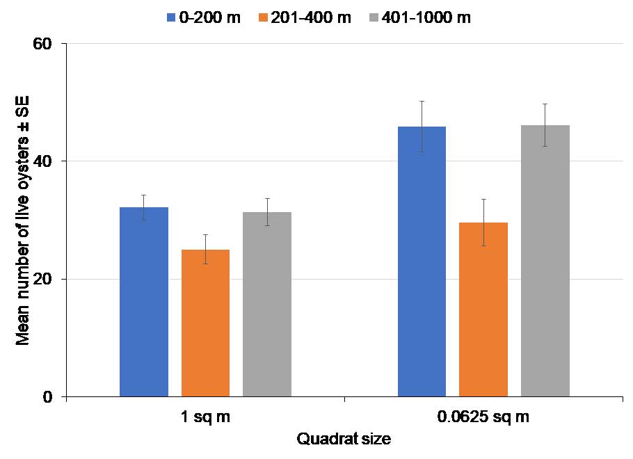 Figure 1. Mean numbers of live oysters ± standard errors (SE). m = meter, sq. m = square meter The project is likely to benefit oysters over time because marshes produce detritus and particulate organic matter which is the basis of the oyster food chain (Bahr, L, and W. Lanier. 1981. The ecology of intertidal oyster reefs of the south Atlantic coast. USFWS OBS-81/15). Research has shown a positive relationship between oyster production and area of saltmarsh (Dame, R, 1976. Energy flow in an intertidal oyster population. Estuarine and Coast Marine Science 4:243-253) and a higher yield of meat by shell volume for oysters near marshes (Manzi, J, et al. 1977. A comparison of growth and survival of subtidal Crassostrea virginica in South Carolina saltmarsh impoundments. Aquaculture 12:293-310). |
||||||||||||||||||
| 43 | Fish, Wildlife, Habitat | The end result of this project will have a net negative impact on the surrounding life. As fish, shrimp, crabs, and birds must follow each other, when one species cannot survive and thus leaves, eventually all others up the food chain will follow. Living on this waterbody, I have witnessed manatee with calves swimming through these canals at high tide every year during the winter. The unique depth provides refuge to the much colder temperatures in the river. As a much-needed source of fresh water, they will troll the banks of the canals suckling the dew or rain from the leaf tips on the low hanging branches of mangrove trees. | The district sponsored sampling of fish in the region by the U.S. Geological Survey from 2002-2004 (Zone C in Figure 1, Turtora, M, and Schotman, E.M., 2010. Seasonal and spatial distribution patterns of finfish and selected invertebrates in coastal lagoons of northeast Florida: 2002-04. U.S. Geological Survey Scientific Investigations Report 2010-5131). Collections in the project area focused mostly on the main stem of the Intracoastal Waterway and some large creeks. This zone of the project area showed low catch-per-unit-effort (CPUE) for the seine gear type and high CPUE for the trawl gear type compared with other zones in the region (from St. Augustine to Ponce Inlet). Seines are selective for small fish size classes including juveniles of many species in shallow water along edges whereas trawls tend to capture larger specimens and are fished in deeper areas, such as channels. In general, however, the project area zone is similar to other zones to the north and south in terms of fish species occurrence and abundance. The study contends that the project area likely is important as a nursery area, therefore the project goal of increasing the footprint of intertidal nursery habitat is supported. Seasonal and spatial distribution patterns of finfish and selected invertebrates in coastal lagoons of northeastern Florida, 2002-2004: U.S. Geological Survey Scientific Investigations Report 2010-5131, 90 p.). Data from seining yielded 145 species that also were caught with the same method in Mosquito Lagoon. Thus, an analysis of data from Mosquito Lagoon is relevant to the area to be restored, and such an analysis can examine the effects of the restoration that was completed in Mosquito Lagoon. Figure 1. Locations sampled during 2002-2004. Data from Florida Fish and Wildlife Conservation Commission’s Fisheries Independent Monitoring program in Mosquito Lagoon can provide insights into the effect of restoration on fish and invertebrates. Fish and invertebrates were sampled with a 21-meter long seine net in 2007–2009 and 2013–2016. The resulting data were classified as being collected during (2009) and after (2013 onward) restoration of dragline ditched wetlands, and they were classified according to distance from restoration (near or ≤ 200 meters or 656 feet, mid-range or 201 to 500 meters or 659 to 1,640 feet, and far or over 500 meters or 1,640 feet). A statistical analysis did not detect a significant interaction between the timing of sampling and distance from restoration (p > 0.05, Table 1), which would be expected if restoration was a major influence on the abundance of fish and invertebrates. We could detect variation in the numbers of animals caught, but the mean numbers of some common and valued fish and invertebrates did not vary in a consistent pattern with the timing of sampling or distance from restoration (Figure 2). 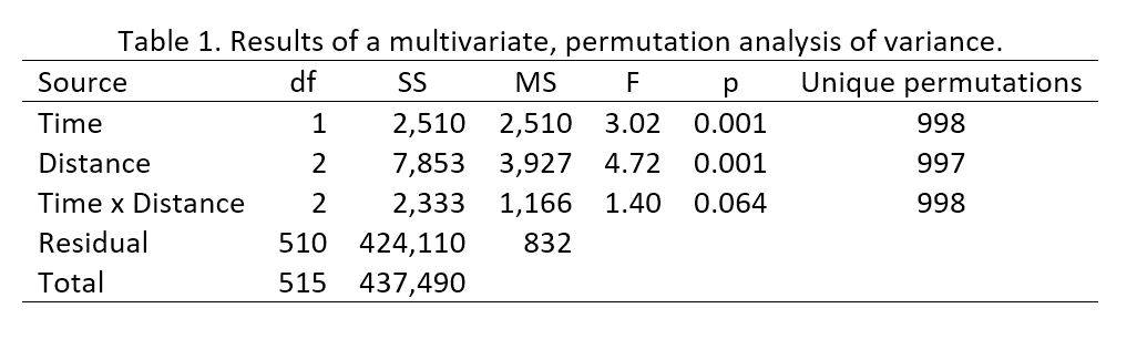 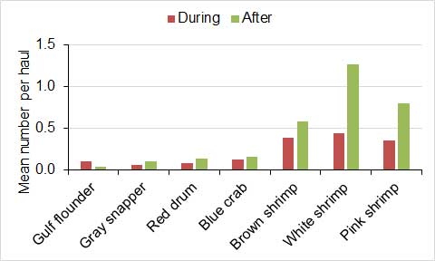 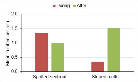 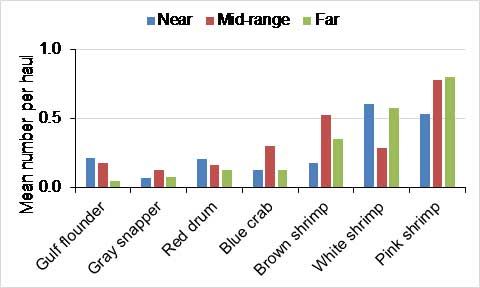 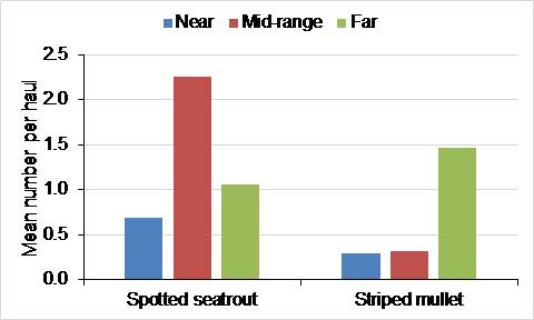 Figure 2. Mean numbers of animals per haul. When considering the effects of restoring ditched wetlands on fish populations, it is important to separate short-term effects, which are described above, and long-term effects, which will be influenced by a variety of factors other than restoration of wetlands. Functional wetlands produce food and provide habitat that ultimately support a variety of fish, with an estimate for a restored wetland in northern Brevard County being 50 pounds of fish per acre (Stevens, P.W., et al. 2006. Fate of fish production in a seasonally flooded saltmarsh. Marine Ecology Progress Series 327: 267-277). Moreover, research provides strong evidence that coastal marshes are preferred or essential habitats for key life stages of most fishery species in Florida as preferred or essential (Seaman, W, ed., 1985. Florida aquatic habitat and fishery resources. Florida Chapter of American Fisheries Society). A research review paper analyzing the eastern US and Gulf shows that commercial landings of estuarine-dependent species on a unit area basis correlates with the ratio of marsh area/open water for many estuaries except for the unique Chesapeake Bay system (Nixon, S, 1980. Between coastal marshes and coastal waters-a review of twenty years of speculation and research on the role of saltmarshes in estuarine productivity and water chemistry. Estuarine Wetland Processes, Plenum Press). Blue crab populations directly relate to wetland area in Florida (Seaman, W, ed., 1985. Florida aquatic habitat and fishery resources. Florida Chapter of American Fisheries Society). According to a study of 27 smooth cordgrass/black needlerush/mangrove locations worldwide, edible shrimp production is directly related to the area of wetland vegetation and not the area, average depth, or volume of estuaries themselves (Turner, R, 1977. Intertidal vegetation and commercial yields of penaeid shrimp. Transactions of the American Fisheries Society 106:411-416). Nevertheless, fish and other top predators tend to get food from multiple sources (Figure 3). Because it requires years for restored areas to recruit plants and build a similar habitat structure and productivity to natural marshes, research shows a lag time for ecosystem services to respond (Craft, C, et al.1999. Twenty-five years of ecosystem development of constructed Spartina alterniflora marshes. Ecological Applications 9:1405-1419). Thus, restoring wetlands may not yield an immediate and obvious increase in fish, but it represents a sensible and proven strategy to safeguard fish populations in the long term. Therefore, future monitoring will be necessary to fully examine the restoration effects. For example, FWC is developing a fish survey protocol designed to target the benefits of the project for the specific habitats in question. 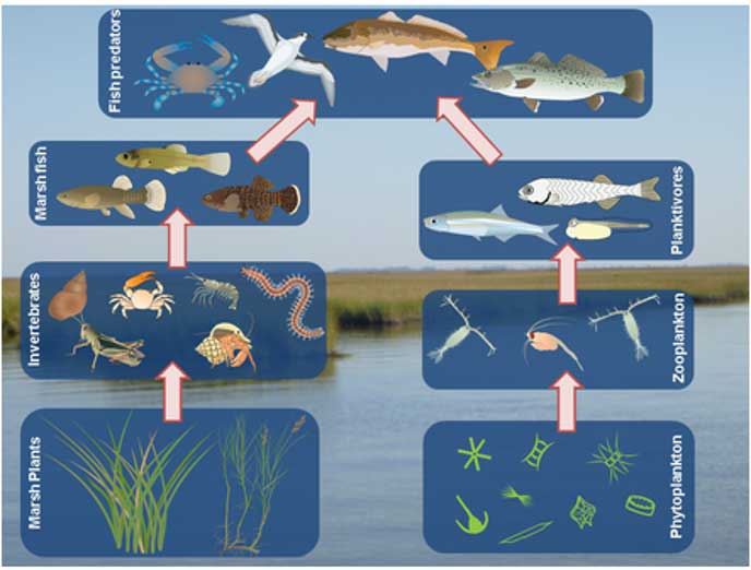 Figure 3. Representation of two trophic webs leading to the same top predators (McCann, M, https://mccannecology.weebly.com/food-webs.html). |
||||||||||||||||||
| 42 | Fish, Wildlife, Habitat | How will the food chain be impacted as fish and shellfish and birds leave the area? | The goal of the project is to enhance the food chain by converting open water back into highly productive wetland habitat which serves 5 key functions: detrital export, nutrient export, sediment trapping, pollutant removal, and providing structural habitat (shelter) for juvenile fish and invertebrates. The spoil piles will be restored to proper elevation to recruit key indicator plants such as smooth cordgrass, black needlerush, and mangroves which are well-known primary producers setting the foundation of the food chain for Florida estuaries through ‘outwelling’ or transfer of plant materials to surrounding waters (Seaman, W, ed., 1985. Florida aquatic habitat and fishery resources. Florida Chapter of American Fisheries Society). Numerous studies, including those using isotopes, show the direct and indirect pathways in which these specific plants provide energy up the food chain (Weinstein, M. et al. 2000. The role of tidal saltmarsh as an energy source for juvenile marine transient finfishes: a stable isotope approach. Transactions of the American Fisheries Society 129:797-810). In fact, a Florida study shows that low marsh of smooth cordgrass/black needlerush is 2-3X more productive than high marsh for plants and invertebrates (Subrahmanyam, C, et al. 1975-80. Studies on the animal communities of two north Florida saltmarsh communities Parts I-III. Bulletin of Marine Science 25, 26, 30). In one year, dead black needlerush decomposes by 35-70% and dead smooth cordgrass by 50-96%, which provides detritus that supports estuarine productivity (Kruczynski, W, et al. 1978. Studies on the plant community of a north Florida saltmarsh. Bulletin of Marine Science 28:316-334). Evidence presented above shows that fish return, oysters do not suffer mortality, and fiddler crabs recolonize the restored wetlands. In addition, monitoring of birds that accompanied monitoring of fiddler crabs showed that birds numbers were not different at restored and nearby undisturbed reference sites based on standard visual surveys (Figure 1, Donnelly, M., Ph.D. dissertation, 2014, University of Central Florida). Again, restoring wetlands safeguards the resilience and improves the health and productivity of the system in the long term.  Figure 1. Mean numbers of birds ± standard errors (SE). C-8, D-12N, D-12S3, D-12S2, D-12S1, V-2 and V-1 = restored areas, D-12R and V-R = undisturbed, reference areas |
||||||||||||||||||
| 41 | Fish, Wildlife, Habitat | Will the project affect (raise) water temperatures in and adjacent to the project area? How will oysters and fiddler crabs be affected? | Temperatures in the open water should not be affected by the restoration. The target organisms, including fishes, are specially adapted to the harsh conditions found within marshes including high temperatures and intertidal conditions. Oysters have not been negatively affected by past restoration projects. Therefore, we do not anticipate that they will be negatively affected by the proposed project. During the summers of 2017 and 2018, 46 randomly selected, oyster reefs in Mosquito Lagoon were surveyed by researchers from the University of Central Florida. During surveys, two methods were used to count live oysters, with each method repeated 4–5 times on each reef. Counts of live oysters generated by both methods were analyzed for significant differences among distances from a restored wetland. The results indicated that the number of live oysters differed significantly among three distances (p  Figure 1. Mean numbers of live oysters ± standard errors (SE). m = meter, sq m = square meter The project is likely to benefit oysters over time because marshes produce detritus and particulate organic matter which is the basis of the oyster food chain (Bahr, L, and W. Lanier. 1981. The ecology of intertidal oyster reefs of the south Atlantic coast. USFWS OBS-81/15). Research has shown a positive relationship between oyster production and area of saltmarsh (Dame, R, 1976. Energy flow in an intertidal oyster population. Estuarine and Coastal Marine Science 4:243-253) and a higher yield of meat by shell volume for oysters near marshes (Manzi, J, et al. 1977. A comparison of growth and survival of subtidal Crassostrea virginica in South Carolina saltmarsh impoundments. Aquaculture 12:293-310). Surveys of fiddler crabs in approximately 80 acres that were restored to wetland elevation (Zones 1, 2 and 3, Figure 2, Donnelly, M., Ph.D. dissertation, 2014, University of Central Florida) showed that their numbers remained similar to those in undisturbed areas (Zone 4, Figure 2) throughout restoration. Numbers on the highest ground (Zone 2 on the top of spoil) increased from zero before restoration to 3–4 crabs per square meter after 24 months because grading the area to the elevation of the surrounding wetland provided a better habitat for crabs (Figure 2). Figure 2. Mean numbers of fiddler crabs per square meter (m2, approximately 11 square feet). |
||||||||||||||||||
| 40 | Fish, Wildlife, Habitat | Will the partners update their information about oyster habitat in the project area? | In the design phase, the partners have worked from the 2015 oyster mapping effort sponsored by the District which included aerial imagery and ground truthing. The project’s contract ecologist will also conduct an extensive, hands-on survey of the project area and identify live oyster bars to reduce the chance of accidental impacts. The partners welcome input from residents and recreational/commercial users of the area who are personally familiar with any unmapped oyster beds. Aerial imagery taken with a drone may provide additional information for updating the map. |
||||||||||||||||||
| 39 | Fish, Wildlife, Habitat | Will fish, wildlife or aquatic life be destroyed during construction? | As mentioned above, we must comply with specific permit conditions related to certain organisms such as protected species. Fish are mobile and will quickly exit the immediate work area. Birds will also leave the immediate area of the work during operations but sometimes remain. Since the work will focus on spoil areas above wetland elevation and the material will be placed in the adjacent ditch, a limited number of invertebrates will be impacted. However, the resulting restored surface will expand the available habitat for many types of these organisms, especially aquatic ones. | ||||||||||||||||||
| 38 | Fish, Wildlife, Habitat | Are there protected, threatened or endangered species in the project area? | Yes, and as outlined in the permit, we will comply with the special conditions associated with in-water work for protected species, should they be seen in the project area during construction. Many of these species use wetlands and will benefit from restoration, especially wading and shore birds, which require intertidal marsh and shallow open areas for feeding, loafing, courtship and nesting. | ||||||||||||||||||
| 37 | Fish, Wildlife, Habitat | Will the project affect oyster reefs? | Oyster reefs were mapped from aerial photography in 2015, and they will be avoided during restoration. During the project, an experienced ecologist will conduct on-site reconnaissance to identify additional reefs, remnant wetlands, natural uplands, and other areas to be avoided. Shellfish harvesting will not be affected by the project because these are unclassified waters and shellfish harvesting is prohibited. |
||||||||||||||||||
| 36 | Fish, Wildlife, Habitat | Will birds return to the site during and after construction? | Surveys of birds at North Peninsula State Park and sites in the Indian River Lagoon document extensive use of the restored areas by shorebirds and wading birds. | ||||||||||||||||||
| 35 | Fish, Wildlife, Habitat | How will fish and fishing be affected by the project? | The project is designed to increase the productivity and resilience of the area. In comparison to restored marshes, the drag-lined marshes are not as productive or resilient to adverse effects, such as storms. Lower productivity and resilience can translate into a decrease or loss of food for fish populations. In addition, deeper dragline channels allow adult predators to feed on juvenile fish that use the marsh as a nursery. While some of the ditches will become shallower and larger fish will move to deeper areas, the restored condition increases production, enhances resilience to unusual events, and provides protection for juveniles to thrive and grow. | ||||||||||||||||||
| 34 | Fish, Wildlife | Will fish/wildlife/aquatic life be killed during the process of this project? | We must comply with specific permit conditions related to certain organisms, such as protected species. Fish are mobile and able to avoid grading of spoil. Birds also tend to leave the immediate area, but some remain. Since the work will focus on spoil areas above wetland elevation and the material will be placed in an adjacent ditch, a limited number of invertebrates will be impacted. However, the resulting restored surface will expand the habitat available to most of these organisms, especially aquatic ones. |
||||||||||||||||||
| 33 | Fish, Wildlife | Have the protected or threatened species of fish or wildlife been identified in each planned piece of the project? | Yes, and the same species are expected in all areas. These species are afforded suitable protection under the permit conditions that apply to the entire area and many of these species will benefit from the project because they rely on the habitat being restored. |
||||||||||||||||||
| 32 | Fish, Wildlife | Are the threatened creatures that live here currently relevant? Yes or no? | Yes. | ||||||||||||||||||
| 31 | Fish, Wildlife | Is the wildlife that is here currently relevant? Yes or no? | Yes. | ||||||||||||||||||
| 30 | Fish, Wildlife | Is the juvenile fish count relevant? Yes or no? | Both. Juvenile fish are an objective of the project, especially for the smallest juveniles (called the post-larval stage). | ||||||||||||||||||
| 29 | Fish | Is there a fish survey, and will another be conducted after the project’s completion? | The district sponsored sampling of fish in the region by the U.S. Geological Survey (USGS) from 2002-2004 (Zone C in Figure 1; Turtora, M, and E Schotman, 2010. Seasonal and spatial distribution patterns of finfish and selected invertebrates in coastal lagoons of northeast Florida: 2002-04. USGS Invest Rpt 2010-5131). Collections in the project area focused mostly on the main stem of the Intracoastal Waterway and some large creeks. This zone of the project area showed low catch-per-unit-effort (CPUE) for the seine gear type and high CPUE for the trawl gear type compared with other zones in the region (from St. Augustine to Ponce Inlet). Seines are selective for small fish size classes including juveniles of many species in shallow water along edges whereas trawls tend to capture larger specimens and are fished in deeper areas, such as channels. In general, however, the project area zone is similar to other zones to the north and south in terms of fish species occurrence and abundance. The study contends that the project area likely is important as a nursery area, therefore the project goal of increasing the footprint of intertidal nursery habitat is supported. Data from seining yielded 145 species that also were caught with the same method in Mosquito Lagoon. Thus, an analysis of data from Mosquito Lagoon is relevant to the area to be restored, and such an analysis can examine the effects of the restoration that was completed in Mosquito Lagoon. Figure 1. Locations sampled during 2002-2004. Data from the Florida Fish and Wildlife Conservation Commission’s Fisheries Independent Monitoring program in Mosquito Lagoon can provide insights into the effect of restoration on fish and invertebrates. Fish and invertebrates were sampled with a 21-meter long seine net in 2007–2009 and 2013–2016. The resulting data were classified as being collected during (2009) and after (2013 onward) restoration of dragline ditched wetlands, and they were classified according to distance from restoration (near or 0.05, Table 1), which would be expected if restoration was a major influence on the abundance of fish and invertebrates. We could detect variation in the numbers of animals caught, but the mean numbers of some common and valued fish and invertebrates did not vary in a consistent pattern with the timing of sampling or distance from restoration (Figure 2).  Figure 2. Mean numbers of animals per haul. When considering the effects of restoring ditched wetlands on fish populations, it is important to separate short-term effects, which are described above, and long-term effects, which will be influenced by a variety of factors other than restoration of wetlands. Functional wetlands do produce food that ultimately supports a variety of fish, with an estimate for a restored wetland in northern Brevard County being 50 pounds of fish per acre (Stevens, P.W., et al. 2006. Fate of fish production in a seasonally flooded saltmarsh. Marine Ecology Progress Series 327: 267-277). Moreover, research provides strong evidence that coastal marshes are preferred or essential habitats for key life stages of most fishery species in Florida (Seaman, W, ed., 1985. Florida aquatic habitat and fishery resources. Florida Chapter of American Fisheries Society). A research review paper analyzing the eastern US and Gulf shows that commercial landings of estuarine-dependent species on a unit area basis correlates with the ratio of marsh area/open water for many estuaries except for the unique Chesapeake Bay system (Nixon, S, 1980. Between coastal marshes and coastal waters-a review of twenty years of speculation and research on the role of saltmarshes in estuarine productivity and water chemistry. Estuarine Wetland Processes, Plenum Press). Blue crab populations directly relate to wetland area in Florida (Seaman, W, ed., 1985. Florida aquatic habitat and fishery resources. Florida Chapter of American Fisheries Society). According to a study of 27 smooth cordgrass/black needlerush/mangrove locations worldwide, edible shrimp production is directly related to the area of wetland vegetation and not the area, average depth, or volume of estuaries themselves (Turner, R, 1977. Intertidal vegetation and commercial yields of penaeid shrimp. Trans Amer Fish Soc 106:411-416). Nevertheless, fish and other top predators tend to get food from multiple sources (Figure 3). Because it requires years for restored areas to recruit plants and build a similar habitat structure and productivity to natural marshes, research shows a lag time for ecosystem services to respond (Craft, C, et al.1999. Twenty-five years of ecosystem development of constructed Spartina alterniflora marshes. Ecol App 9:1405-1419). Thus, restoring wetlands may not yield an immediate and obvious increase in fish, but it represents a sensible and proven strategy to safeguard fish populations in the long term. Therefore, future monitoring will be necessary to fully examine the restoration effects. For example, FWC is developing a fish survey protocol designed to target the benefits of the project for the specific habitats in question. Figure 3. Representation of two trophic webs leading to the same top predators (McCann, M, https://mccannecology.weebly.com/food-webs.html). |
||||||||||||||||||
| 28 | Construction, Water quality | It is loosely worded in the project job description that the spoil pile materials are not going to be pushed into main canals. However, given the average height of these piles, there is simply far too much material to be spread around for it not to wind up in the main canals. The silt that is created from disturbing these areas as well as the run-off during heavy rains as a result of loss of vegetation that was removed during this project (As shown in the aerial photo on the SJRWMD restoration project website) will undoubtedly wind up in every creek, canal, and basin, despite anyone’s best efforts. The vegetation that is removed will require many months to repatriate. During this time run-off from affected areas will wash and settle unabated. Placements of containment booms and silt screens during the project will ultimately have little effect on stopping this despite any assurances that may be given. | Turbidity has never been documented to be an issue with this method of restoration. When the question was raised previously, an experiment was designed to look for problems with water quality during and after restoration work at Shipyard Island within Canaveral National Seashore in Volusia County (see more detailed answer provided elsewhere). There were no patterns in water quality that indicated the work was an issue. Turbidity was monitored for six months after the work in the area was completed. There were no issues with turbidity any time after work was completed. The construction contractor has committed to providing turbidity control measures as required by the permits. The scope of work anticipates the need to leave turbidity barriers in place for up to two months after completion of work in each section. SJRWMD and the third-party contractor will be taking turbidity measurements to determine when the earthwork has stabilized sufficiently, and the barriers can be removed. A more detailed evaluation of effects on water quality is provided elsewhere. It includes targeted sampling at one restored site and broad-scale sampling in the waters surrounding multiple, successful projects. |
||||||||||||||||||
| 27 | Construction, Water quality | Can the turbidity barriers stay in place longer? | The construction contractor is required and has committed to providing turbidity control measures as required by the permits. The scope of work anticipates the need to have turbidity barriers for up to two months after completion of work in each work area. SJRWMD and the third-party contractor will be taking turbidity measurements to determine when the earthwork has stabilized sufficiently and the barriers can be removed. Turbidity has never been documented to be an issue with this restoration method. When the question was raised previously, an experiment was designed to look for problems with water quality during and after restoration work at Shipyard Island within Canaveral National Seashore in Volusia County (see answer to the question regarding monitoring that follows). There were no patterns in water quality associated with the work. Turbidity was monitored for six months after the work in the area was completed. There were no issues with turbidity any time after work was completed. |
||||||||||||||||||
| 26 | Construction, Noise | Are airboats going to be utilized by the contractor to fuel and supply the excavator? If so, what restrictions will be in place to keep noise to a minimum, as well as keeping them off the oysters? | No. The construction contractor has stated they intend to use a pontoon boat to service their excavation equipment. This vessel will be under the same permit and contract requirements as previously stated. UPDATE: The District has approved the contractor’s request to use a second excavator. The new excavator will be brought into the project area on or after June 13, 2019. The second excavator will help to expedite completion of the project and finishing more segments during the growing season should also help the restored wetlands revegetate sooner. The second excavator is an amphibious Caterpillar 312D, which is slightly smaller than the Caterpillar 320D already in use. |
||||||||||||||||||
| 25 | Construction, Noise | How loud will the machine be while working on the property? | 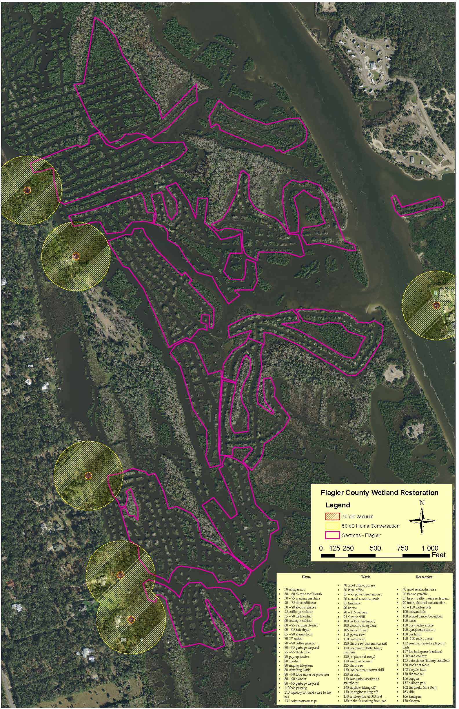 The noise from the diesel engine of the amphibious excavator is comparable to engines in standard excavation equipment. This type of equipment generates sound at a level of 99 decibels right next to the engine. Homes closest to the work area are more than 160 feet away. At that distance, the noise level would decrease to 55 decibels — generally equivalent to the sound of human conversation, or lower. The noise from the diesel engine of the amphibious excavator is comparable to engines in standard excavation equipment. This type of equipment generates sound at a level of 99 decibels right next to the engine. Homes closest to the work area are more than 160 feet away. At that distance, the noise level would decrease to 55 decibels — generally equivalent to the sound of human conversation, or lower.UPDATE: The District has approved the contractor’s request to use a second excavator. The new excavator will be brought into the project area on or after June 13, 2019. The second excavator will help to expedite completion of the project and finishing more segments during the growing season should also help the restored wetlands revegetate sooner. The second excavator is an amphibious Caterpillar 312D, which is slightly smaller than the Caterpillar 320D already in use. It will generate similar noise as the 320D. |
||||||||||||||||||
| 24 | Construction, Mangroves | Can the turbidity barriers stay in place longer? | The construction contractor has committed to providing turbidity control measures as required by the permits. The scope of work anticipates the need to leave turbidity barriers in place for up to two months after completion of work in each section. SJRWMD and the third-party contractor will be taking turbidity measurements to determine when the earthwork has stabilized sufficiently and the barriers can be removed. Turbidity has never been documented to be an issue with this method of restoration. When the question was raised previously, an experiment was designed to look for problems with water quality during and after restoration work at Shipyard Island within Canaveral National Seashore in Volusia County (see answer to the question regarding monitoring that follows). There were no patterns in water quality that indicated the work was an issue. Turbidity was monitored for six months after the work in the area was completed. There were no issues with turbidity any time after work was completed. |
||||||||||||||||||
| 23 | Construction, Mangroves | What is the plan for choosing which mangroves to remove? | The permit authorizes clearing of vegetation and grading of spoil that are above the targeted elevation. Some mangroves located between the spoil and the ditch to be filled will be impacted by restoration. Spoil will be graded in a manner that impacts as few mangroves as possible. Larger mangroves will be given preference for preservation. The small areas of mangroves impacted by the work will become part of larger and more robust areas that are appropriate for multiple types of wetland vegetation, including recolonization by mangroves. A related comment specifically mentioned 62-330.405 General Conditions for All General Permits (12) and its prohibition on impacting “forested wetlands.” However, this condition relates to activities that are not stipulated elsewhere in the permit, and clearing of vegetation, including mangroves, during grading of spoil piles is authorized in our permit. Additionally, the general condition specifically addresses impacts to vegetation and other features during creation of “temporary vehicle access” to the project area, not activities within the area to be restored. |
||||||||||||||||||
| 22 | Construction, Habitat | Is there enough soil to grade out to marsh elevations? | Only areas where the remaining spoil is above the target wetland elevation will be graded. If the area is not above wetland elevation, it will not be disturbed. Natural uplands, oyster reefs and intact wetlands will be avoided. There is not enough spoil to convert all the ditches to wetlands, so some areas will remain as open water. See example maps below depicting areas with differing amounts of spoil remaining near the ditches and examples of how the spoil MAY be graded. The area with large remaining spoil piles produces a larger restored wetland footprint. Areas with less remaining spoil may produce proportionally less restored wetland. These are examples only, and the actual restoration will be different.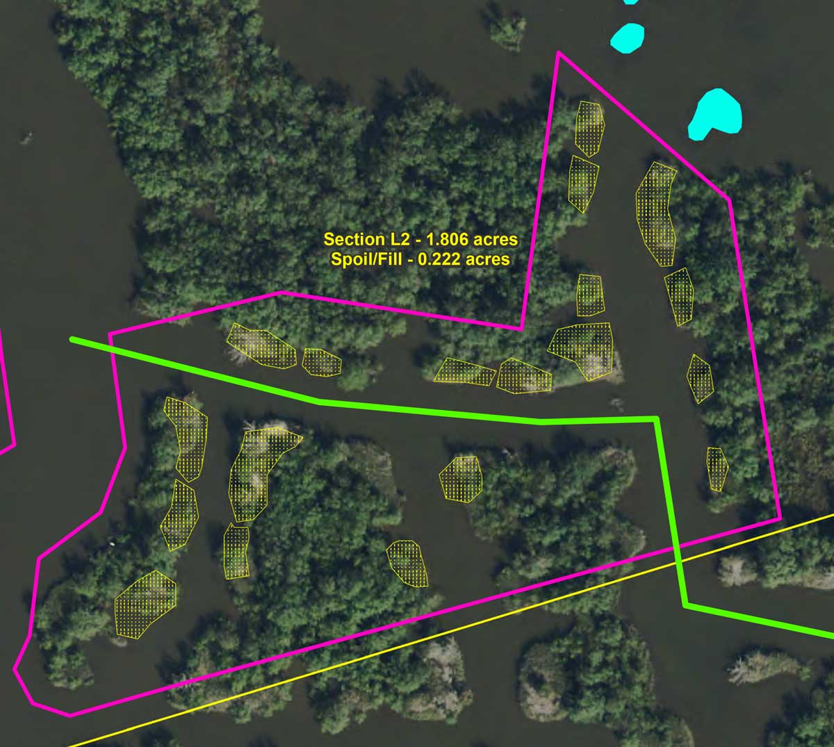 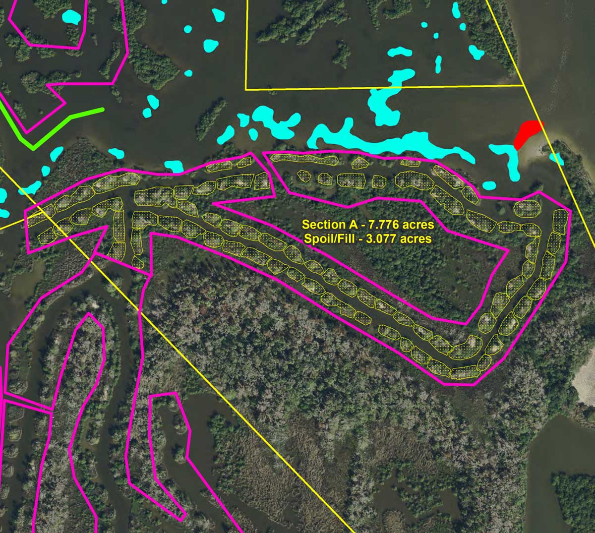 |
||||||||||||||||||
| 21 | Construction, Habitat | How will target elevations be determined? | Target elevations will be determined in each section by existing intact wetland and biological cues from existing plants. As an example of a biological cue, black mangrove pneumatophores (air roots) grow based on the water levels they typically experience over time. This provides an integrated measure of water levels and a good relative target for the final elevation of the graded spoil. | ||||||||||||||||||
| 20 | Construction | A salt marsh restoration site in Tampa bay used 1,137 plugs per acre and since the district believes this project will create 40 acres of usable salt marsh they will need 45,480 plugs. | The partners have never considered planting as a critical component of the approach. Initial revegetation through natural recruitment happens very quickly, typically within a few months. For this project, nearby homeowners have expressed an interest in planting, and the partnership is attempting to accommodate this request. Portions of the restored wetlands may be revegetated, thanks to a commitment from partners to provide appropriate plant material. Volunteers will be solicited to participate in the replanting, with a focus on areas adjacent to residences along the west side of the project. | ||||||||||||||||||
| 19 | Construction | How many plant plugs are available? | At least 5,000. | ||||||||||||||||||
| 18 | Construction | Across the United States, the new salt marsh restored height standard is 11.8 inches above sea level after a study of rising sea levels was noted for the loss of current salt marshes. This study was done in 2012. Will the salt marsh be built by these standards? Rising waters equal less salt marshes. Other projects adhere to these standards. | No, in part because we don’t believe the standards are national due to variation in tides, mean sea levels, rate of sea level rise, rate of subsidence, and other mitigating factors. Our focus will be on getting the elevation correct so that the area returns to as near its original ecological trajectory as possible. We could not find the report that detailed the work on establishing a target elevation, but based on the website provided, we believe it applies to the Blackwater National Wildlife Refuge. It is worth pointing out that the work in the refuge was raising the level of subsided marshes, rather than repairing marshes damaged by ditching, and the fact that sea levels are not rising at the same rate everywhere. In addition, the marshes in question are undergoing subsidence as mentioned in the paragraph below taken from: Lerner, J.A., Curson, D.R., Whitbeck, M. and Meyers, E.J., Blackwater 2100: A strategy for salt marsh persistence in an era of climate change, 2013, The Conservation Fund (Arlington, VA) and Audubon MD-DC (Baltimore, MD). Maryland is particularly vulnerable to sea level rise because of its geographic location, elevation and geology. With thousands of miles of coastline and acres of low urban and rural areas, the State is highly vulnerable to sea level rise and coastal storms. The Chesapeake Bay region is frequently subjected to tropical storms and nor’easters. These major storms can produce high tidal surges, heavy wave action, and torrential rainfall. Land subsidence also affects the relative rate of sea level rise. The Chesapeake region is still sinking as the surface of the northern part of the continent rebounds as result of being released from the massive glaciers that covered much of the Northern Hemisphere 10,000 years ago. Other factors contribute to the region’s faster relative sea level rise compared with global levels. However, the greatest factor in future decades will be the warming global climate. We have recognized that subsidence has affected some wetlands along Florida’s east coast, and a pilot project was undertaken to see if dredged material could successfully be used to elevate subsided areas to a level where they become viable marshes. Nevertheless, we feel that getting spoil piles down to marsh elevation is step one. Other work may need to be done in the future to protect the resulting habitat from boat wakes, help it overcome subsidence, or help it cope with other stressors. We have thought about how to address such issues, but thus far, getting the elevation correct has been successful in most cases. |
||||||||||||||||||
| 17 | Construction | Will the project be built by todays salt marsh restoration standards? | Yes, standards that we have established for this region via past work, including a pilot project. | ||||||||||||||||||
| 16 | Construction | Have you identified the spoil piles targeted? If not, when will that be done? | Many likely targets have been identified. On-site determinations will be made as the project progresses. |
||||||||||||||||||
| 15 | Construction | Do you know how deep the ditches were dug during the original dragline ditching in this project area and how deep are they now? | No. They all vary. |
||||||||||||||||||
| 14 | Construction | Is the level of the spoil pods the only concern of the SJRWMD staff? Yes or no? | No; however, getting the elevation correct is very critical and the key to the overall success of this restoration effort. | ||||||||||||||||||
| 13 | Construction | What experience does the construction contractor have working in systems and on projects such as this? | The contractor has more than 30 years of experience working in a variety of terrestrial and aquatic environments. They have successfully performed work for the SJRWMD that includes fine grading and use of amphibious equipment. In his own words, the owner of the company states, We approach each project with the attitude necessary to exceed all project requirements public and/or private. They have also retained an environmental company to provide site-specific training regarding sensitive habitats and threatened/endangered species. In addition to the contractor's experience, district staff and a third-party contractor will ensure the quality of the contractor's performance, including avoiding damage to sensitive areas, such as oyster bars. The contract includes provisions to address contractor deficiencies, should they occur, including stopping work, remediation of deficiencies, and terminating the contract. | ||||||||||||||||||
| 12 | Construction | What kind of equipment will be used? | The project calls for the restoration to be performed by a Caterpillar 320D long reach excavator mounted on new pontoons — a self-crawling, track-driven amphibious excavator. This type of equipment is often generically called a "marsh buggy," though the specific pontoon-mounted excavator for this project is not the branded vehicle. This type of vehicle only generates approximately 2 pounds per square inch of pressure on the ground because its weight is distributed over the entire bottom of the pontoons. This amount of pressure is comparable to a person standing on one foot. Thus, the equipment can move across a wetland without causing damage. In this process, there is no grinding or pounding, just clearing plants and moving soil. UPDATE: The District has approved the contractor’s request to use a second excavator. The new excavator will be brought into the project area on or after June 13, 2019. The second excavator will help to expedite completion of the project and finishing more segments during the growing season should also help the restored wetlands re-vegetate sooner. The second excavator is an amphibious Caterpillar 312D, which is slightly smaller than the Caterpillar 320D already in use. 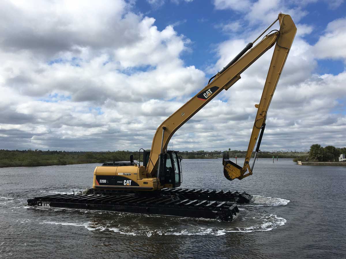 |
||||||||||||||||||
| 11 | Construction | What hours will construction take place? | Working hours will be between 7 a.m. and 6 p.m., with no work occurring on holidays or weekends. Exceptions must be approved by SJRWMD. | ||||||||||||||||||
| 10 | Construction | What does the construction entail? | Work areas will be isolated behind turbidity barriers installed at the interfaces between the estuary and all tidal creeks and ditches. An amphibious excavator will clear vegetation on targeted spoil piles and place it in the portion of the ditch to be filled. Spoil will be returned to the borrow ditch to cover the vegetation. The excavator will work primarily from the existing ditches, moving backwards and filling the ditch behind it. All surfaces will be leveled to the elevation of existing, adjacent wetlands (no slope), which is just inches above mean water level. Excavation below the level of existing marsh will not occur, and no natural uplands will be leveled. UPDATE: The District has approved the contractor’s request to use a second excavator. The new excavator will be brought into the project area on or after June 13, 2019. The second excavator will help to expedite completion of the project and finishing more segments during the growing season should also help the restored wetlands revegetate sooner. The second excavator is an amphibious Caterpillar 312D, which is slightly smaller than the Caterpillar 320D already in use. |
||||||||||||||||||
| 09 | Construction | What is the timeline for the Flagler County wetland restoration project? | The project is scheduled to be completed within one year from the start of construction. | ||||||||||||||||||
| 08 | Budget, Construction | Is there a property value study; the impact of home values during and after the project? | No. |
||||||||||||||||||
| 07 | Budget, Construction | Has there been an economic impact study? | No. |
||||||||||||||||||
| 06 | Budget, Construction | Do you have a reserve budget if there are damages (oyster beds, etc.) during/after the Project? Who should be contacted if that is discovered? | Yes. We have an established protocol to follow, with our on-site personnel being first points of contact. |
||||||||||||||||||
| 05 | Aesthetics, Revegetation | Will the partners consider revegetation of former spoil piles? | Portions of the restored wetlands may be revegetated, thanks to a commitment from project partners to provide appropriate plant material. Volunteers will be solicited to participate in the replanting in the areas adjacent to residences along the west side of the project. | ||||||||||||||||||
| 04 | Aesthetics, Revegetation | How long will it take to see the property returned to normal? | Initial revegetation happens very quickly, typically within a few months. As an example, similar sites at the Merritt Island National Wildlife Refuge had 10 to 30 percent cover by six months and 50 to 80 percent cover by 18 months. Response may vary due to weather, availability of plants to recruit to the area and other factors not related to the restoration process. | ||||||||||||||||||
| 03 | Aesthetics, Habitat | Can the plan be altered by not removing the vegetation immediately in front of homeowners' properties? | Many areas on the side of the project near residences are intact wetlands or on private lands. The project calls for clearing and leveling spoil areas in the project, not areas that currently are wetlands. Ground-level views are not expected be significantly altered. However, the district is working with stakeholders to fine tune the project footprint in hopes of addressing their concerns about vistas, noise, navigation and recreation. | ||||||||||||||||||
| 02 | Aesthetics, Construction | What changes are we going to see? | Spoil areas will be cleared of vegetation and graded to wetland elevation. On average, about 40 percent of the acreage in a given area is returned to wetland because there is not enough spoil remaining to fill the ditches. In this case, about 40 acres is expected to be returned to functional wetland that will provide food for fish and wildlife, buffering against storm surge, filtering and cleaning of water, and other benefits.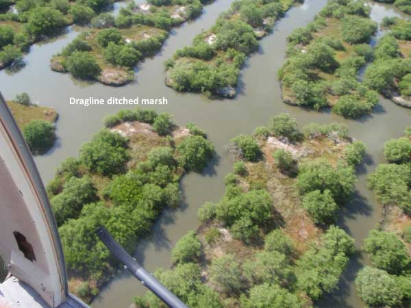 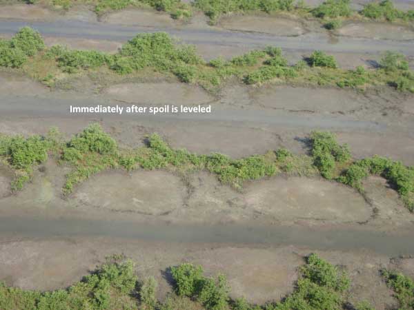 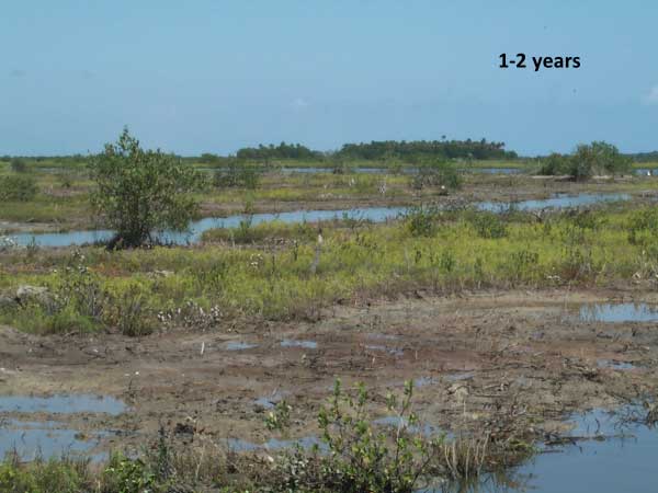 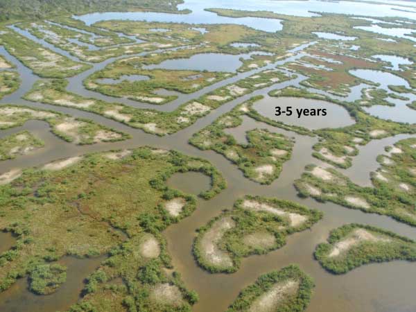 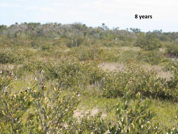 |
||||||||||||||||||
| 01 | Overview, Partners | Who is responsible for the Flagler County Wetland Restoration Project? | This restoration project is conducted by a partnership involving the St. Johns River Water Management District (SJRWMD or district), U.S. Fish and Wildlife Service (USFWS), Florida Fish and Wildlife Conservation Commission (FWC), and Florida Department of Environmental Protection (FDEP) State Park System and Aquatic Preserves. |