It’s always National Estuaries Week at the District

What is an estuary?
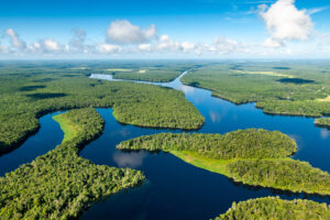
An estuary is an area where freshwater and saltwater meet and mix. Estuaries are transition zones between ecosystems, for example, where a river flows into the ocean.
It’s time again to celebrate our estuaries, those special places where salt water and freshwater mix and mingle, creating productive, beautiful and complex water bodies.
National Estuaries Week (Sept. 19–26) is part of a nationwide celebration where organizations and communities from across the country gather at their local bays, riverfronts and inlets to learn about and celebrate the importance of estuaries and how they benefit our coastal way of life.
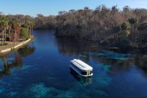
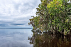
At the St. Johns River Water Management District, finding ways to restore and protect estuaries is our passion. We’re fortunate to have several estuaries within our 18-county jurisdiction. Our largest, the Indian River Lagoon, is officially recognized as an Estuary of National Significance through the U.S. Environmental Protection Agency’s National Estuary Program. We also have the lower 40 miles of the St. Johns River (between Black Creek and the river’s mouth at Mayport), and miles of waterways in the District’s Northern Coastal Basins, which includes stretches of the Nassau, St. Marys, Guana, Tolomato and Matanzas rivers that are influenced by the Atlantic Ocean.
Estuaries are often economic centers of coastal communities. They provide habitat for species that support more than 75 percent of U.S. commercial fishing and an even higher percentage of the recreational fish catch, according to the National Oceanic and Atmospheric Administration (NOAA). Millions of people visit estuaries every year to boat, swim, watch birds and other wildlife, and to fish. These areas also help protect the coastline from storm surge and offer beautiful vistas and space for recreation. We realize the value of our estuaries and have invested tens of millions of dollars in their protection and restoration.
Every day, our scientists and program managers are focused on projects — including cost-share projects with partners — such as creating stormwater treatment areas that capture nutrients before they can reach the estuaries, dredging accumulated sediments (known as muck) that cause ecological damage and restoring coastal wetlands.
Here are a few highlights showing how we’re using science, engineering and “turn dirt” projects to benefit our estuaries:
In the Lower St. Johns River Basin
- In the mid-2000s, we disbursed tens of millions of dollars for wastewater treatment plant upgrades, and for regional stormwater treatment in the Tri-County Agricultural Area (from Palatka to south of Orange Park along the eastern shoreline) to reduce the loads of phosphorus, nitrogen and suspended solids flowing into the St. Johns River.
- Our data, analysis, modeling and participation in stakeholder outreach were instrumental in establishing both the Florida Department of Environmental Protection’s (DEP) Total Maximum Daily Loads (TMDLs) and Basin Management Action Plan (BMAPs) for the lower St. Johns River, Crescent Lake and Lake George.
- Since 2013, we harvested 7.4 million pounds of gizzard shad, a “rough fish” from Lake George, which reduced the recycling of nutrients from sediments to the water and directly removed more than 61,300 pounds of phosphorus contained in the fishes’ bodies.
- The Doctors Lake Phosphorus Removal Pilot Project, now in operation, will reduce dissolved phosphorus in discharges from the Clay County Utility Authority’s Fleming Island Regional Wastewater Plant to improve water quality and reduce algal growth.
In the Northern Coastal Basin
- We developed a watershed-based Surface Water Improvement and Management (SWIM) Plan in 2003 to enhance, restore and manage the water quality and wetland resources within the basin’s estuaries.
- We’ve established a water quality monitoring network, allowing us to track and evaluate stormwater management in the Northern Coastal Basins. This allows us to provide technical assistance to help guide projects to treat stormwater undertaken by local governments.
- We’ve provided cost-share funding to communities within the Northern Coastal Basin for various water quality and flood protection projects.
- We’ve work with partners to restore more than 23,000 acres of coastal wetlands that provide key habitat and improve water quality.
In the Indian River Lagoon
- We provide financial and technical support to the independent Indian River Lagoon National Estuary Program (the IRL Council).
- We conduct water quality monitoring and modeling, as well as seagrass monitoring.
- We continue to provide cost-share funding and management for water quality improvement projects.
- We’ve competed significant projects that either capture nutrients before they can reach the lagoon or have redirected and treated freshwater flows in canals to the St. Johns River instead of the lagoon.
- We play key roles in developing, supporting and adapting DEP’s TMDL and BMAPs to restore much of the lagoon, and such restoration is particularly challenging because the lack of a major river makes the lagoon more sensitive than other estuaries in the District.
Our work to improve water quality in our estuaries continues. We recently finished accepting applications for $25 million in funding to support projects that improve water quality in the Indian River Lagoon. Gov. Ron DeSantis and the Florida Legislature approved this funding for fiscal year 2020–2021. Stay tuned!