Managing prescribed fire through satellite technology benefits taxpayers
Information gathered from European Space Agency satellites is enabling the St. Johns River Water Management District to more effectively map and monitor prescribed burns and wildfires across large areas of Florida … and doing so for pennies per acre!
As part of its land management program, the District uses prescribed fire to reduce the possibility of dangerous wildfires, while enhancing environmental conditions on the more than 450,000 acres of public land that is directly managed by the District. Setting lands ablaze is pretty much a straightforward and standardized exercise. Mapping and tracking the effectiveness of those charred swaths is another matter altogether.
Traditionally, staff have relied on data gathered from airplanes or Unmanned Aerial Vehicles (UAVs, commonly called drones) to determine how prescribed fire and wildfire impact the habitats on District land This information also helps District land managers develop an annual strategy for prescribed burns. Prescribed burns remove extra fuel that builds up in ecosystems, thereby reducing the risk of high-intensity, uncontrollable wildfires. However, both methods of aerial mapping are time- intensive and can be costly.
The District turned to satellite technology for more timely, accurate and cost-effective mapping of prescribed burns and wildfires. Through a competitive bidding process, the agency chose Rezatec, a United Kingdom-based company, to fulfil the task.
“It’s freeing up a lot of staff time,” says Bill VanSickle, a District GIS analyst. “Since the early 1990s, we took pictures out the window of the aircraft where we knew a prescribed burn had occurred. However, if we didn’t know a wildfire had occurred, we wouldn’t know to look for a scar.”
What’s more, aerial photographs, also called “oblique” images, are limited in their accuracy and it can take a lot of time to tie the photos to the earth’s surface (georeference) for mapping, he adds.
“From an airplane, the landscape nearby looks big and clear,” VanSickle says. “Further away, the view looks small and “smoky” grey-blue, so the image quality, color and resolution will vary from one side of the picture to the other. Using oblique imagery to map a burn is better than nothing but is very time-consuming and fraught with error.”
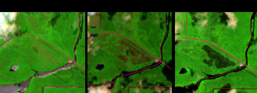
Time lapse imagery shows changes in the landscape of the marsh just south of U.S. Hwy. 192 near the Three Forks Conservation Area (Brevard County).
Previously used UAV mapping is limited to small areas (less than about 1,500 acres) per mission, because UAVs can only cover about 120 acres during each half-hour flight. VanSickle says he is limited to a dozen flights per day on a good day, adding that “it takes at least twice that much time to plan the projects beforehand, travel to and from the worksite, and process the resulting imagery into mosaics.”
Using the old methods, VanSickle estimates that mapping a year’s worth of burns on 180,000 acres of District land would require about two years of staff time for planning, imaging, processing and analyzing in order to complete a single annual report. Now, District staff gets a complete package of information every month, with 90 percent accuracy, for about a tenth of the amount of time previously required.
As they orbit the earth, the satellites utilize optical imagery and radar to image the entire planet about once per week, capturing about a quarter of an acre in each pixel. Rezatec then processes multiple scenes and compares them to one another using Artificial Intelligence (AI) to detect changes from one week or month to the next. The technology is so advanced that it can discern various types of vegetation or textures and can oftentimes indicate whether a dark area is a muddy wetland or a fire-scarred landscape. Because the Sentinel-1 Radar can see through cloud cover, cloudy days have no impact on their capabilities. Because the District receives reports monthly, staff can easily see any changes on District land and plan their future management strategies accordingly.
“Satellite technology gives us top quality answers at a price of less than a nickel per acre,” VanSickle says. “Taking advantage of the latest and best technology allows us to carry out our mission at the lowest possible cost while maintaining the highest quality results.”