Modeling is a complex process that supports much of the District’s scientific work
May 7, 2020

In this age of instant gratification, when so many of us can join a remote business meeting with just one stroke of a computer key, it takes deep dedication to do the complex modeling work that informs so many of our decisions at the St. Johns River Water Management District.
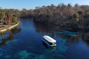
The District uses models in its regulatory work, to help determine minimum flows and levels to preserve the health of water bodies, to warn about and adjust potential negative impacts from project construction and for water supply planning. It’s a long, complicated, scientific process that supports so much of what we do, and one that staff ensure is done with rigorous quality assurance checks.
Our team of experts in the fields of geology, engineering, hydraulics and hydrology first look at what question needs to be answered. Whether the District is working on a long-term water supply planning modeling effort that is partially based on historic rainfall and surface water levels (such as rivers and streams) or a regulatory limitation to determine how much groundwater is available in a certain area, this team must first identify the problem and then determine what information and assumptions need to be included in the model. Only after each of these steps can our experts accurately begin to analyze the situation.
The models depend on new and historical data, valuable information collected by our teams engaged in ambient monitoring throughout the District. Once a question is defined, the pertinent data are gathered, converted to the proper data type/format for use by the computer model, compared against known factors to ensure accuracy, peer reviewed by outside experts, and simulated to provide an answer. So much data and computing time is needed that each step could take three to six months to complete, with massive amounts of mathematical computations processed to reach an answer (sometimes 30 to 50 equations for each time increment in the simulation; for example, multiply 24 solutions to 30 equations each day for several years; lots of calculations!).
The District’s staff enter huge volumes of information in already rigorously tested and proven models to customize each model for our region’s unique environmental and geological features. When staff are assured a model is ready to provide an answer for the question, it takes computers anywhere from a few minutes to several days to provide that answer, and many iterations are required after that to make sure simulations closely match observed conditions and provide a reasonable result.