

A Journey on the St. Johns River: The headwaters
This is the first part of a series about the St. Johns River. The installments explore all or portions of the river’s three distinct basins, the land that water flows across or under on its way to a river. We begin with the river’s headwaters, also known as the upper basin.
Hector Herrera pilots the airboat as it winds through a serpentine corridor of swaying sawgrass. The vegetation is so tall and dense that every blind curve on the watery trail promises surprise. It might be a scattering of juvenile alligators, their striped torsos a blur of black and yellow, or skittish egrets scattering at the sound of the airboat’s strident snarl.
The reedy tangle eventually yields to a fisheye lens vista of marsh and sky. Herrera kills the motor and the airboat glides gently to a stop. The silence is instantaneous. As the ears adjust, the ambient sounds become apparent: the distant sound of coots squawking an ancient language in the fringes of the marsh, the cry of an osprey somewhere overhead. The concept of time becomes hazy in the headwaters of the St. Johns River. Hours are measured by the sun’s arc instead of clocks, seasons by slight dips in temperature instead of calendars.
“This is where it all begins,” says Herrera, a senior professional engineer with the St. Johns River Water Management District who has played many roles in the restoration of the Upper St. Johns River Basin during the past 25 years. “From here, the river makes its way north to the Atlantic Ocean.”
Downstream, the St. Johns will declare itself a mighty river, but here in Indian River and Brevard counties, there are few defined banks and boundaries. Waterfowl, wading birds, river otters and alligators inhabit the maze of open marsh, tributaries and hardwood swamps.
The St. Johns River is commonly divided into three drainage basins, which are land areas that drain into a water body. Because the St. Johns River flows north, the upper basin is the area to the south. The middle basin is the area in east-central Florida where the river widens and flattens out. The lower basin is the area in northeast Florida from Putnam County to the river’s mouth in Duval County, where it empties into the Atlantic Ocean.
Click the map below to see images of the Upper St. Johns River Basin.

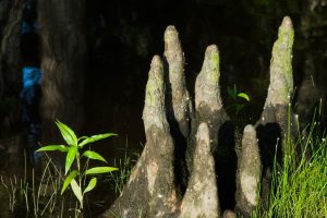
The upper basin portion of the river is fed entirely by rainfall. Open marshes and cypress domes conjure up images of the Florida Everglades instead of a river. It is here where the river begins a 310-mile-long journey north to the ocean. The river’s total drop from beginning to end is less than 30 feet, or about one inch per mile. Remarkably, about 94 percent of the river’s change in slope occurs entirely within the upper basin, making the St. Johns River one of the “laziest” rivers in the world.
Rebirth of the upper basin
In the 1940s and 50s, much of the Upper St. Johns River Basin was reduced to a shadow of its former self. In fact, by the early 1970s, 62 percent of the entire marsh of the upper basin had been drained for other land uses, including cattle ranching, citrus and row crops. A grid of canals diverted floodwaters from the basin east to the Indian River Lagoon.
Draining off the headwaters of the St. Johns River came at a cost: loss of water storage areas, diminished water quality, excessive freshwater going into the lagoon, and significant decreases in fish and wildlife populations. The marsh that remained was further degraded by hydrologic alterations and nutrients in stormwater runoff.
“Many of the people who visit this marsh to boat and fish might not realize this same area was once farmed,” Herrera says of the Blue Cypress Water Management Area. “Although the marsh may never be exactly as it once was, our goal is to mimic the natural hydrology of the river as closely as possible.”
The evolution of the river’s headwaters from a degraded marsh to a flood control project can be traced to a series of hurricanes in the 1920s and 1940s and devastating floods in central and southern Florida. The disasters prompted the state to establish modern flood control projects in 1948. By the 1950s, the U.S. Army Corps of Engineers (USACE) and the Central and Southern Florida Flood Control District began designing a large flood control project in the upper basin. Construction started in 1966.
By 1973, much of the flood control project — including Canal 54, located near Fellsmere in Indian River County and the largest canal in the upper basin — was complete, but an Environmental Impact Statement determined that it had unacceptable impacts on a hardwood swamp known as Jane Green. Additionally, freshwater discharges from Canal 54 into the north prong of the St. Sebastian River caused big swings in the salinity of the Indian River Lagoon. The project was shut down until a new plan could be developed.
In 1977, the District and USACE embarked on an ambitious, long-term flood control project that would revitalize the upper basin by reclaiming the drained former marshes and low-lying areas that surround the river, also called a floodplain. It was an ideal partnership: The District bought the land and USACE built reservoirs and structures, replumbing existing canals. The basic idea of the project was to acquire as much of the historic floodplain as possible and re-establish the function of the floodplain marsh to store floodwaters instead of routing the floodwaters to tide. The redesigned project improved water quality, reduced freshwater discharges to the Indian River Lagoon, improved potential water supply availability, and restored thousands of acres of wetland habitat for birds, fish and wildlife.
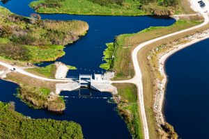
The upper basin project today includes more than 100 miles of flood protection levees, eight major gated spillway structures and at least 15 smaller water control structures, culverts and weirs. During flood conditions, the project may contain more than 550,000 acre-feet of water — an amount that could cover an 86-square-mile area with 10 feet of water.
Completed in 2016, the project is breathtaking in its beauty and sheer size. Encompassing 247 square miles, it extends from the Florida Turnpike in Indian River County northward to Lake Washington in central Brevard County. It is one of the most ambitious flood control and floodplain/wetland restoration projects of its kind in the world.
The impacts of the upper basin project have not gone unnoticed. An Australian river advocacy organization awarded the International Thiess (pronounced TEASE) River Prize to the District in October 2008 in recognition of the upper basin project. The Australian award recognized the project as a modern model of floodplain management, balancing the needs of the river with people’s needs. In August 2016, the Florida Engineering Society lauded the upper basin project as a “Project of the Century,” presenting project engineers with an excellence in engineering award. This was the second major award to recognize this project.
“The upper basin project is an innovative approach to managing water,” Herrera says. “Instead of relying heavily on structures and pumping to control water movement, we worked with the Corps toward a ‘semi-structural’ concept, balancing flood control with significant environmental habitat restoration and water quality protection benefits.”
Herrera points the airboat north toward a canal. The canal jogs sharply to the west and merges with another canal where he turns south. The locals call this stretch, appropriately, “Zig-Zag canal.” The canal suddenly transforms into one of the most remote and remarkable lakes in St. Johns River system, or the state for that matter. We’re entering Blue Cypress Lake, perhaps one of the best-kept secrets of the St. Johns River. Ringed by marshes and a cypress swamp, the shoreline here is negligible. For that reason — and more likely due to its remoteness — the only sign of human impact is a small fish camp on the western shore of the lake. The remainder of Blue Cypress is dominated by ospreys, whose distinctive cries carry through the cypress trees as they roost and fish the waters.
Blue Cypress is the southernmost lake in the St. Johns River. The lake’s name comes from the blue appearance of the cypress trees as the morning sun‘s rays reflect off the water.
“This lake is an oasis,” Herrera says. “There aren’t many lakes in Florida that aren’t ringed with development. The birds outnumber people here.”