Resiliency is embedded in our core missions
Resilience. It has become a familiar term in the media and in the scientific community as leaders work to develop long-term strategies to address the expected impacts of sea-level rise and increased flooding from storm events fueled by a changing climate.
Within 48 hours of being sworn in, Gov. Ron DeSantis signed an executive order that placed additional emphasis on Florida’s environment and water resources. Resiliency is a natural fit at the St. Johns River Water Management District, where staff quietly work behind the scenes to address resiliency through the District’s core missions — water supply, water quality, flood protection and enhancement of natural systems.
“Everything the District does has a resilience element,” says Tom Frick, the District’s Director of the Division of Strategic Planning and Initiatives. “Whether we’re protecting water supplies through our permitting program or restoring natural systems to improve storm surge and flood protection, resilience is part of our philosophy.”
Perhaps one of most breathtaking examples of the District’s resilience projects — in terms of sheer size — is its Upper St. Johns River Basin Project, spanning nearly 170,000 acres in Indian River and Brevard counties. Four decades in the making, the Upper Basin Project is a collaboration between the District and the U.S. Army Corps of Engineers (USACE). It is one of the most ambitious flood control and wetland restoration projects in the world.
The District’s Bureau of Operations and Maintenance is charged with ensuring the project remains resilient in the face of whatever Mother Nature dishes out in the future. It’s no small task: The Upper Basin Project includes more than 100 miles of flood protection levees, eight major gated spillway structures and more than 80 smaller water control structures, culverts, weirs and pump stations. During flood conditions, the project may contain more than 550,000 acre-feet of water — an amount that could cover an 86-square-mile area with 10 feet of water.

The District maintains water control structures in the Upper St. Johns River Basin Project as part of its resiliency strategy. Shown here is structure S-96C.
As the local sponsor for the Upper Basin Project and a second USACE flood control project in the Ocklawaha River Basin, District staff monitor water levels and weather conditions around the clock.
“Each water body we manage has an established regulation schedule (a tool used by water managers to manage the water levels in canals and reservoirs) and it is our mission to meet this schedule at all times,” says Woody Boynton, Bureau Chief for the District’s Bureau of Operations and Maintenance. “Maintaining water bodies at or near the regulation schedule minimizes the risk of potential overtopping or other levee failures.”

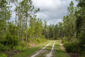
Levees like L-76 in the Upper St. Johns River Basin Project require ongoing maintenance to ensure the flood control project is always in optimal condition as part of the District’s emphasis on resiliency.
District engineers rely on an abundance of information, including internal and U.S. Geological Survey data showing water levels, live camera views at structures, National Weather Service rainfall forecasts, wind maps, and geographical tropical survey analyses.
The District has also upgraded the technology used to operate water control structures. Where once staff operated gates manually in response to weather forecasts and predicted water levels, staff use cameras and telemetry to respond immediately to changing conditions.
District Engineer Matt Forhan is the “man behind the curtain,” operating water control structures in the Upper St. Johns and Ocklawaha river basins with a computer and a phone from District headquarters in Palatka. He watches for anomalies in water level data, notifies stakeholders of changes relevant to them and participates in a yearly statewide hurricane exercise and twice-yearly levee and structure inspections required by USACE.
“In the old days, we would look at data and see something is amiss, but there was up to a three-hour time delay,” he says. “Through telemetry and cameras, I can respond immediately and see the water discharge I’m expecting.”
On the maintenance side of things, District Public Works crews wage a constant battle against the ravages of nature. Over the past decade the District has completed $16 million in repairs and upgrades to the upper basin’s flood control system. This work is integral to the agency’s resiliency effort and core missions, Boynton says.
“Every upgrade we make gives us the capacity to better manage flooding during storms,” Boynton says. “Resiliency is being able to adapt to variations in nature, whether it’s a drought year or a wet year.”
Ironically, the most common culprit in the degradation of levees and structures is the very element that the District is charged with protecting and preserving: water.
“Erosion is the most common challenge we face,” Boynton says. “Whether this is caused by tractors rutting the levee, large rain events or animals that damage the levee, maintaining a healthy stand of grass on the slopes is a year-round challenge,” Boynton says. “We’re also dealing with Florida’s climate and the rate at which plants grow in Florida. Vegetation can overtake a levee if you don’t have a maintenance program in place. If you miss a year, the vegetation can regain a foothold and you’re back to major vegetation removal, which is more time consuming and expensive. Timing is everything.”
Every upgrade we make gives us the capacity to better manage flooding during storms.
Join the District on Jan 28, 6-8 p.m., for a public webinar on the District’s flood protection role and Emergency Action Plans associated with the federal flood protection projects. During the webinar, District staff will raise public awareness of the federal levee systems and associated risks. Also, staff will explain District efforts to reduce risks and ensure that our levees and water control structures continue to operate as needed to protect the public from flooding and provide resilience as the climate continues to evolve.
Learn more about the District’s ongoing resiliency work in a newly updated section of our website. We’ve provided a summary of our recent work, as well as resources to help our local government partners.
The District has created “Levee System Summaries” for each of the federal
flood risk reduction systems it manages. View them on this website.